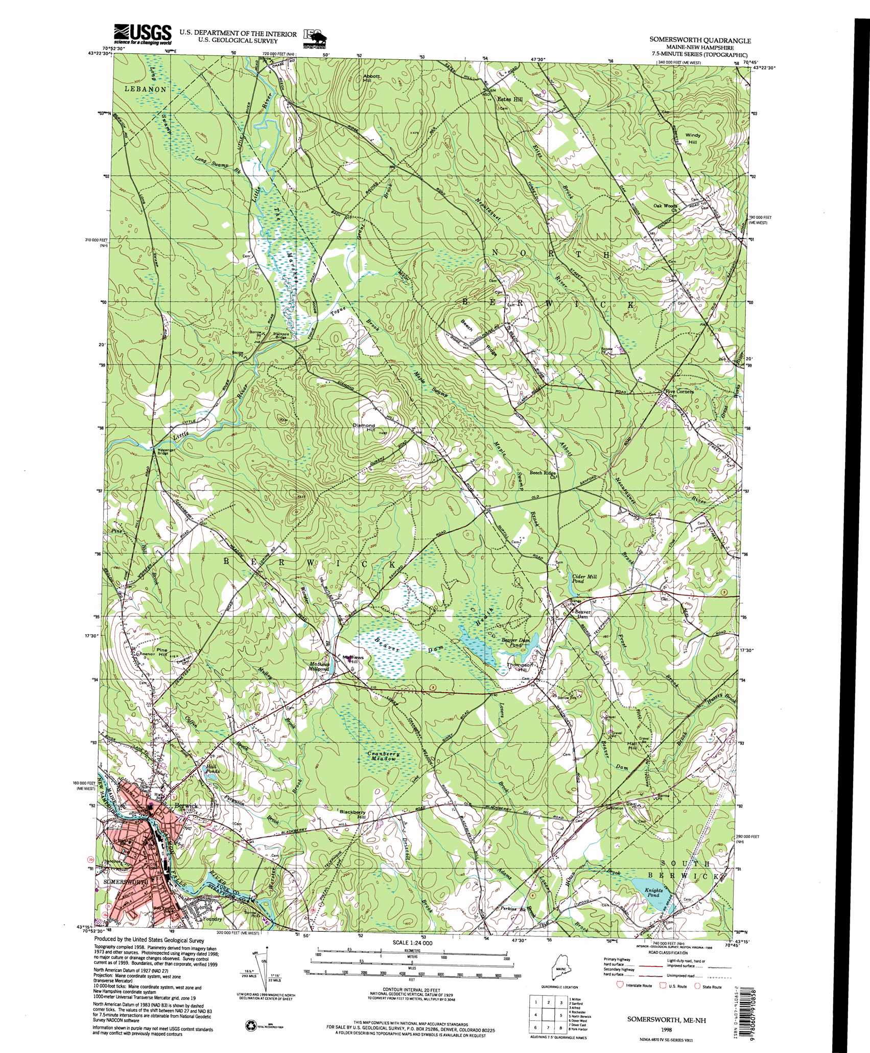
Somersworth Topo Map Maine
To zoom in, hover over the map of Somersworth
USGS Topo Quad 43070c7 - 1:24,000 scale
| Topo Map Name: | Somersworth |
| USGS Topo Quad ID: | 43070c7 |
| Print Size: | ca. 21 1/4" wide x 27" high |
| Southeast Coordinates: | 43.25° N latitude / 70.75° W longitude |
| Map Center Coordinates: | 43.3125° N latitude / 70.8125° W longitude |
| U.S. States: | ME, NH |
| Filename: | o43070c7.jpg |
| Download Map JPG Image: | Somersworth topo map 1:24,000 scale |
| Map Type: | Topographic |
| Topo Series: | 7.5´ |
| Map Scale: | 1:24,000 |
| Source of Map Images: | United States Geological Survey (USGS) |
| Alternate Map Versions: |
Somersworth NH 1958, updated 1960 Download PDF Buy paper map Somersworth NH 1958, updated 1974 Download PDF Buy paper map Somersworth NH 1958, updated 1988 Download PDF Buy paper map Somersworth NH 1958, updated 1988 Download PDF Buy paper map Somersworth NH 1977, updated 1979 Download PDF Buy paper map Somersworth NH 1998, updated 1999 Download PDF Buy paper map Somersworth NH 2012 Download PDF Buy paper map Somersworth NH 2015 Download PDF Buy paper map |
1:24,000 Topo Quads surrounding Somersworth
Sanbornville |
Great East Lake |
Mousam Lake |
Waterboro |
Bar Mills |
Farmington |
Milton |
Sanford |
Alfred |
Kennebunk |
Baxter Lake |
Rochester |
Somersworth |
North Berwick |
Wells |
Barrington |
Dover West |
Dover East |
York Harbor |
York Beach |
Epping |
Newmarket |
Portsmouth |
Kittery |
> Back to 43070a1 at 1:100,000 scale
> Back to 43070a1 at 1:250,000 scale
> Back to U.S. Topo Maps home
Somersworth topo map: Gazetteer
Somersworth: Bridges
Messenger Bridge elevation 70m 229′Stackpole Bridge elevation 73m 239′
Somersworth: Dams
Beaver Dam Pond Dam elevation 55m 180′Cider Mill Dam elevation 52m 170′
Great Falls Upper Dam elevation 52m 170′
New Dam elevation 37m 121′
Somersworth: Lakes
Hall Ponds elevation 72m 236′Knights Pond elevation 31m 101′
Mathews Millpond elevation 57m 187′
Somersworth: Parks
Jules Bisson Park elevation 46m 150′Noble Pines Park elevation 84m 275′
Spring Hill Recreation Area elevation 35m 114′
Somersworth: Populated Places
Berwick elevation 52m 170′Estes Hill elevation 136m 446′
Five Corners elevation 67m 219′
Foundry elevation 43m 141′
Newichawanoc (historical) elevation 52m 170′
Somersworth elevation 71m 232′
Somersworth: Reservoirs
Beaver Dam Pond elevation 55m 180′Cider Mill Pond elevation 52m 170′
Salmon Falls River Reservoir elevation 52m 170′
Somersworth: Ridges
Beech Ridge elevation 140m 459′Somersworth: Streams
Abbott Brook elevation 36m 118′Adams Brook elevation 30m 98′
Beaver Dam Brook elevation 36m 118′
Coffin Brook elevation 41m 134′
Estes Brook elevation 77m 252′
Ferguson Brook elevation 36m 118′
Frost Brook elevation 36m 118′
Grant Brook elevation 76m 249′
Hilton Brook elevation 30m 98′
Long Swamp Brook elevation 76m 249′
Maple Swamp Brook elevation 53m 173′
Mulloy Brook elevation 42m 137′
Perkins Brook elevation 33m 108′
Togue Brook elevation 73m 239′
Worster Brook elevation 20m 65′
Somersworth: Summits
Abbott Hill elevation 166m 544′Birch Hill elevation 103m 337′
Blackberry Hill elevation 68m 223′
Diamond Hill elevation 148m 485′
Hall Hill elevation 54m 177′
Mathews Hill elevation 69m 226′
Pine Hill elevation 123m 403′
Thompson Hill elevation 63m 206′
Windy Hill elevation 138m 452′
Somersworth: Swamps
Beaver Dam Heath elevation 59m 193′Cranberry Meadow elevation 53m 173′
Long Swamp elevation 89m 291′
Maple Swamp elevation 76m 249′
The Marshes elevation 77m 252′
Somersworth digital topo map on disk
Buy this Somersworth topo map showing relief, roads, GPS coordinates and other geographical features, as a high-resolution digital map file on DVD:
Maine, New Hampshire, Rhode Island & Eastern Massachusetts
Buy digital topo maps: Maine, New Hampshire, Rhode Island & Eastern Massachusetts