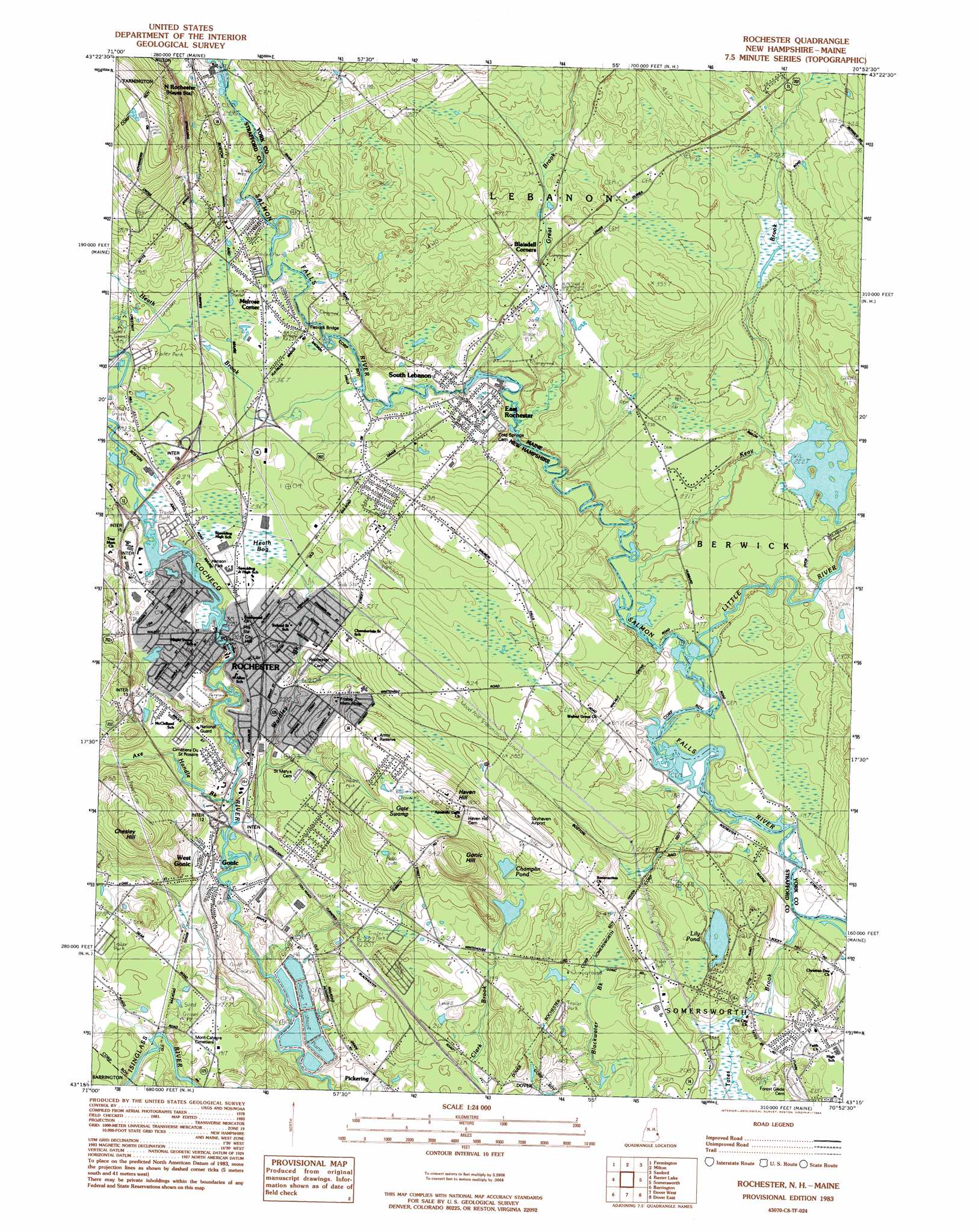
Rochester Topo Map New Hampshire
To zoom in, hover over the map of Rochester
USGS Topo Quad 43070c8 - 1:24,000 scale
| Topo Map Name: | Rochester |
| USGS Topo Quad ID: | 43070c8 |
| Print Size: | ca. 21 1/4" wide x 27" high |
| Southeast Coordinates: | 43.25° N latitude / 70.875° W longitude |
| Map Center Coordinates: | 43.3125° N latitude / 70.9375° W longitude |
| U.S. States: | NH, ME |
| Filename: | o43070c8.jpg |
| Download Map JPG Image: | Rochester topo map 1:24,000 scale |
| Map Type: | Topographic |
| Topo Series: | 7.5´ |
| Map Scale: | 1:24,000 |
| Source of Map Images: | United States Geological Survey (USGS) |
| Alternate Map Versions: |
Rochester NH 1983, updated 1984 Download PDF Buy paper map Rochester NH 1983, updated 1984 Download PDF Buy paper map Rochester NH 2012 Download PDF Buy paper map Rochester NH 2015 Download PDF Buy paper map |
1:24,000 Topo Quads surrounding Rochester
Wolfeboro |
Sanbornville |
Great East Lake |
Mousam Lake |
Waterboro |
Alton |
Farmington |
Milton |
Sanford |
Alfred |
Parker Mountain |
Baxter Lake |
Rochester |
Somersworth |
North Berwick |
Northwood |
Barrington |
Dover West |
Dover East |
York Harbor |
Mount Pawtuckaway |
Epping |
Newmarket |
Portsmouth |
Kittery |
> Back to 43070a1 at 1:100,000 scale
> Back to 43070a1 at 1:250,000 scale
> Back to U.S. Topo Maps home
Rochester topo map: Gazetteer
Rochester: Airports
Salmon Falls Airport elevation 57m 187′Skyhaven Airport elevation 94m 308′
Rochester: Bridges
Copps Bridge elevation 70m 229′Copps Bridge elevation 70m 229′
Flatrock Bridge elevation 61m 200′
Rochester: Crossings
Interchange 10 elevation 70m 229′Interchange 11 elevation 38m 124′
Interchange 12 elevation 52m 170′
Interchange 13 elevation 73m 239′
Interchange 14 elevation 82m 269′
Interchange 15 elevation 71m 232′
Interchange 16 elevation 78m 255′
Interchange 7 elevation 57m 187′
Interchange 8 elevation 73m 239′
Interchange 9 elevation 71m 232′
Rochester: Dams
Baxter Mill Dam elevation 61m 200′Champlin Pond Dam elevation 82m 269′
Gonic Dam elevation 41m 134′
Mast Point Dam elevation 52m 170′
Mill Pond Dam elevation 41m 134′
Rochester City Dam Number 1 elevation 69m 226′
Rochester Sewage Lagoons Dikes elevation 49m 160′
Rochester: Lakes
Lily Pond elevation 60m 196′Wallingford Pond elevation 77m 252′
Rochester: Parks
Forest Glade Park elevation 67m 219′Hanson Park elevation 71m 232′
Rochester Commons elevation 67m 219′
Roger Allen Park elevation 72m 236′
Rochester: Populated Places
Blaisdell Corners elevation 76m 249′East Rochester elevation 70m 229′
Gonic elevation 55m 180′
Melrose Corner elevation 75m 246′
North Rochester elevation 85m 278′
Pickering elevation 46m 150′
Rochester elevation 70m 229′
South Lebanon elevation 69m 226′
West Gonic elevation 61m 200′
Rochester: Post Offices
Rochester Post Office elevation 70m 229′Rochester: Reservoirs
Champlin Pond elevation 82m 269′Cocheco River Reservoir elevation 41m 134′
Cocheco River Reservoir elevation 69m 226′
Lake Murdock elevation 68m 223′
Rochester Sewage Lagoons elevation 49m 160′
Salmon Falls River Reservoir elevation 52m 170′
Salmon River Reservoir elevation 61m 200′
Rochester: Streams
Axe Handle Brook elevation 54m 177′Great Brook elevation 60m 196′
Heath Brook elevation 64m 209′
Keay Brook elevation 56m 183′
Little River elevation 55m 180′
Peters Marsh Brook elevation 56m 183′
Pine Hill Brook elevation 57m 187′
Tates Brook elevation 52m 170′
Rochester: Summits
Chesley Hill elevation 133m 436′Gonic Hill elevation 136m 446′
Haven Hill elevation 129m 423′
Rochester: Swamps
Gate Swamp elevation 103m 337′Heath Bog elevation 72m 236′
Rochester digital topo map on disk
Buy this Rochester topo map showing relief, roads, GPS coordinates and other geographical features, as a high-resolution digital map file on DVD:
Maine, New Hampshire, Rhode Island & Eastern Massachusetts
Buy digital topo maps: Maine, New Hampshire, Rhode Island & Eastern Massachusetts