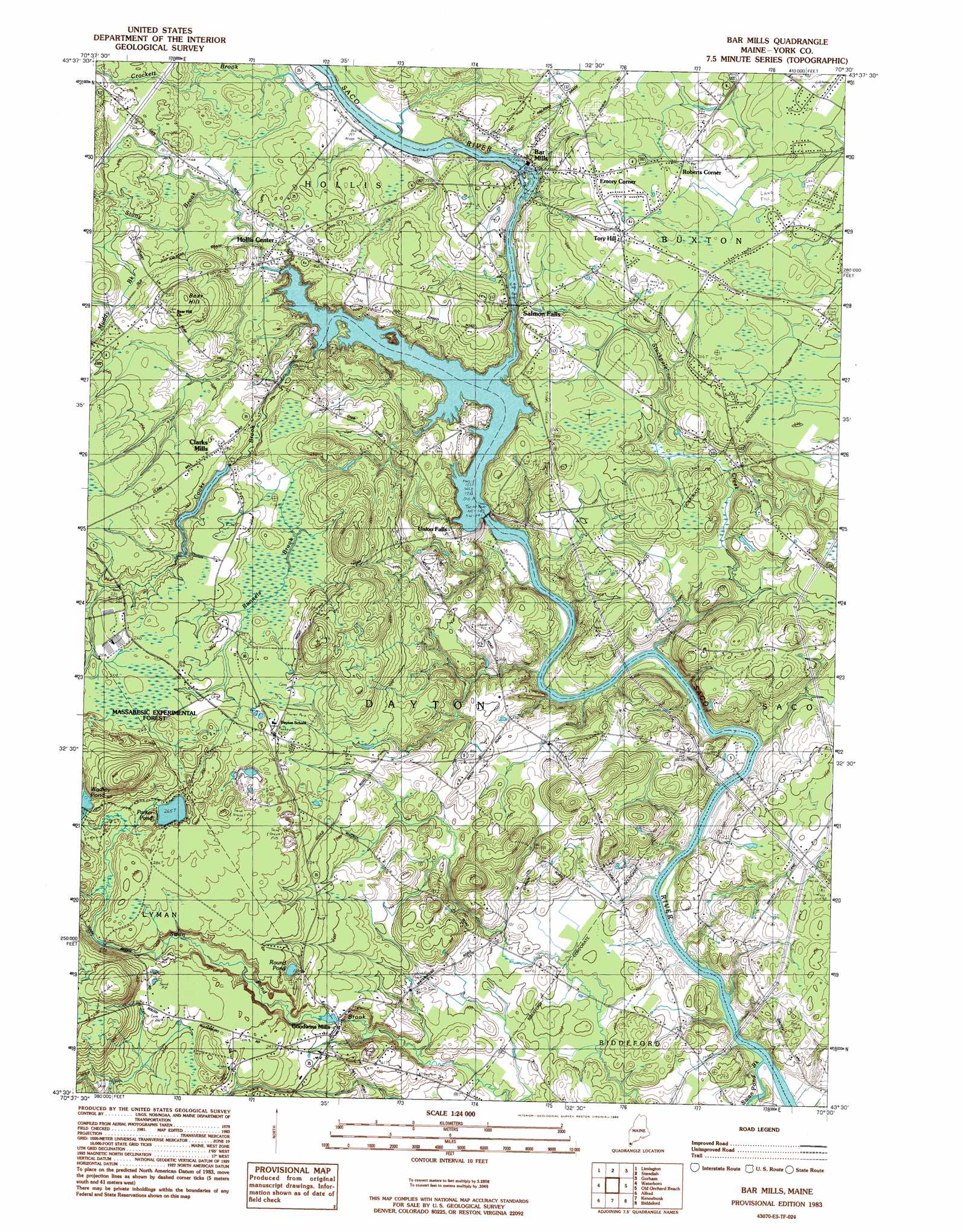
Bar Mills Topo Map Maine
To zoom in, hover over the map of Bar Mills
USGS Topo Quad 43070e5 - 1:24,000 scale
| Topo Map Name: | Bar Mills |
| USGS Topo Quad ID: | 43070e5 |
| Print Size: | ca. 21 1/4" wide x 27" high |
| Southeast Coordinates: | 43.5° N latitude / 70.5° W longitude |
| Map Center Coordinates: | 43.5625° N latitude / 70.5625° W longitude |
| U.S. State: | ME |
| Filename: | o43070e5.jpg |
| Download Map JPG Image: | Bar Mills topo map 1:24,000 scale |
| Map Type: | Topographic |
| Topo Series: | 7.5´ |
| Map Scale: | 1:24,000 |
| Source of Map Images: | United States Geological Survey (USGS) |
| Alternate Map Versions: |
Bar Mills ME 1983, updated 1984 Download PDF Buy paper map Bar Mills ME 2011 Download PDF Buy paper map Bar Mills ME 2014 Download PDF Buy paper map |
1:24,000 Topo Quads surrounding Bar Mills
Cornish |
Steep Falls |
Sebago Lake |
North Windham |
Cumberland Center |
Limerick |
Limington |
Standish |
Gorham |
Portland West |
Mousam Lake |
Waterboro |
Bar Mills |
Old Orchard Beach |
Prouts Neck |
Sanford |
Alfred |
Kennebunk |
Biddeford |
Biddeford Pool |
Somersworth |
North Berwick |
Wells |
Kennebunkport |
> Back to 43070e1 at 1:100,000 scale
> Back to 43070a1 at 1:250,000 scale
> Back to U.S. Topo Maps home
Bar Mills topo map: Gazetteer
Bar Mills: Dams
Bar Mills Dam elevation 41m 134′Cooks Brook Dam elevation 66m 216′
Goodwins Mills Dam elevation 47m 154′
Roberts-Wadley Pond Dam elevation 83m 272′
Skelton Dam elevation 39m 127′
Bar Mills: Lakes
Parker Pond elevation 81m 265′Round Pond elevation 65m 213′
Wadley Pond elevation 83m 272′
Bar Mills: Parks
Salmon Falls East Historic District elevation 59m 193′Salmon Falls West Historic District elevation 38m 124′
Bar Mills: Populated Places
Bar Mills elevation 44m 144′Clarks Mills elevation 74m 242′
Emory Corner elevation 73m 239′
Goodwins Mills elevation 58m 190′
Hollis Center elevation 55m 180′
Roberts Corner elevation 71m 232′
Salmon Falls elevation 40m 131′
Tory Hill elevation 74m 242′
Union Falls elevation 38m 124′
Bar Mills: Reservoirs
Roberts-Wadley Pond elevation 83m 272′Saco River Reservoir elevation 39m 127′
Saco River Reservoir elevation 45m 147′
Swan Pond Creek elevation 62m 203′
Bar Mills: Streams
Cooks Brook elevation 38m 124′Crockett Brook elevation 46m 150′
Locke Brook elevation 52m 170′
Muddy Brook elevation 60m 196′
Stackpole Creek elevation 16m 52′
Stony Brook elevation 38m 124′
Swan Pond Brook elevation 19m 62′
Bar Mills: Summits
Bear Hill elevation 87m 285′Bar Mills digital topo map on disk
Buy this Bar Mills topo map showing relief, roads, GPS coordinates and other geographical features, as a high-resolution digital map file on DVD:
Maine, New Hampshire, Rhode Island & Eastern Massachusetts
Buy digital topo maps: Maine, New Hampshire, Rhode Island & Eastern Massachusetts