South Harpswell Topo Map Maine
To zoom in, hover over the map of South Harpswell
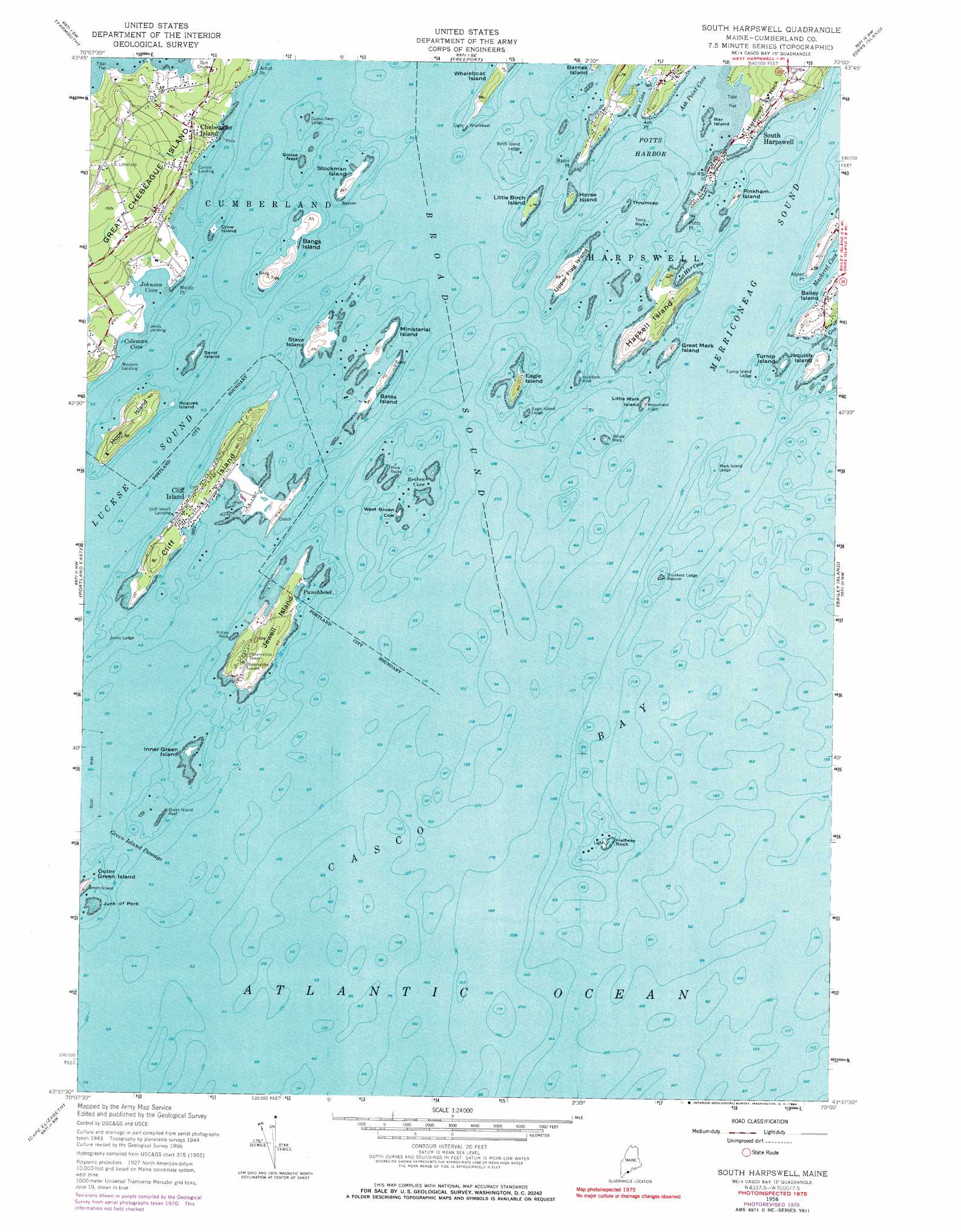
USGS Topo Quad 43070f1 - 1:24,000 scale
| Topo Map Name: | South Harpswell |
| USGS Topo Quad ID: | 43070f1 |
| Print Size: | ca. 21 1/4" wide x 27" high |
| Southeast Coordinates: | 43.625° N latitude / 70° W longitude |
| Map Center Coordinates: | 43.6875° N latitude / 70.0625° W longitude |
| U.S. State: | ME |
| Filename: | o43070f1.jpg |
| Download Map JPG Image: | South Harpswell topo map 1:24,000 scale |
| Map Type: | Topographic |
| Topo Series: | 7.5´ |
| Map Scale: | 1:24,000 |
| Source of Map Images: | United States Geological Survey (USGS) |
| Alternate Map Versions: |
South Harpswell ME 1944 Download PDF Buy paper map South Harpswell ME 1956, updated 1959 Download PDF Buy paper map South Harpswell ME 1956, updated 1971 Download PDF Buy paper map South Harpswell ME 1956, updated 1984 Download PDF Buy paper map South Harpswell ME 2011 Download PDF Buy paper map South Harpswell ME 2014 Download PDF Buy paper map |
1:24,000 Topo Quads surrounding South Harpswell
Gray |
North Pownal |
Lisbon Falls South |
Brunswick |
Bath |
Cumberland Center |
Yarmouth |
Freeport |
Orrs Island |
Phippsburg |
Portland West |
Portland East |
South Harpswell |
Bailey Island |
Small Point |
Prouts Neck |
Cape Elizabeth |
|||
Biddeford Pool |
> Back to 43070e1 at 1:100,000 scale
> Back to 43070a1 at 1:250,000 scale
> Back to U.S. Topo Maps home
South Harpswell topo map: Gazetteer
South Harpswell: Bars
Birch Island Ledge elevation 0m 0′Eagle Island Ledge elevation 0m 0′
Eastern Drunkers Ledge elevation 0m 0′
Goose Nest Ledge elevation 0m 0′
Green Island Reef elevation 0m 0′
Indian Rock elevation 0m 0′
Johns Ledge elevation 0m 0′
Junk of Pork elevation 0m 0′
Mark Island Ledge elevation 0m 0′
Mink Rocks elevation 0m 0′
Northwest Ledge elevation 0m 0′
Stave Island Ledge elevation 0m 0′
Torry Rock elevation 0m 0′
Turnip Island Ledge elevation 0m 0′
Webster Rock elevation 0m 0′
South Harpswell: Bays
Ash Point Cove elevation 2m 6′Broad Sound elevation 0m 0′
Broken Cove elevation 0m 0′
Casco Bay elevation 0m 0′
Cocktail Cove elevation 0m 0′
Coleman Cove elevation 0m 0′
Fishermans Cove elevation 0m 0′
Great Harbor Cove elevation 0m 0′
Johnson Cove elevation 1m 3′
Mackerel Cove elevation 0m 0′
Merriconeag Sound elevation 0m 0′
Potts Harbor elevation 0m 0′
Punchbowl elevation 0m 0′
South Harpswell: Capes
Abner Point elevation 4m 13′Artist Point elevation 7m 22′
Ash Point elevation 0m 0′
Basin Point elevation 0m 0′
Harpswell Neck elevation 18m 59′
Potts Point elevation 0m 0′
Waldo Point elevation 1m 3′
South Harpswell: Channels
Green Island Passage elevation 0m 0′South Harpswell: Falls
Basion Cove Falls elevation 8m 26′South Harpswell: Guts
Jaquish Gut elevation 6m 19′South Harpswell: Islands
Bangs Island elevation -1m -4′Bar Island elevation 0m 0′
Bates Island elevation 0m 0′
Cliff Island elevation 16m 52′
Crow Island elevation 1m 3′
Drunker Ledge elevation 0m 0′
Eagle Island elevation 0m 0′
Goose Nest elevation 0m 0′
Great Chebeague Island elevation 50m 164′
Great Mark Island elevation 5m 16′
Haddock Rock elevation 0m 0′
Halfway Rock elevation 1m 3′
Haskell Island elevation 11m 36′
Hope Island elevation 22m 72′
Horse Island elevation 0m 0′
Inner Green Island elevation 3m 9′
Jaquish Island elevation 7m 22′
Jewell Island elevation 12m 39′
Little Birch Island elevation 0m 0′
Little Jewell Island elevation 4m 13′
Little Mark Island elevation 0m 0′
Ministerial Island elevation 0m 0′
Outer Green Island elevation 12m 39′
Pinkham Island elevation 6m 19′
Rogues Island elevation 1m 3′
Sand Island elevation 1m 3′
Stave Island elevation 3m 9′
Stockman Island elevation 0m 0′
Thrumcap elevation 0m 0′
Turnip Island elevation 0m 0′
Upper Flag Island elevation 7m 22′
West Brown Cow elevation 0m 0′
Whale Rock elevation 0m 0′
South Harpswell: Parks
Lobstermans Statue elevation 2m 6′South Harpswell: Populated Places
Central Landing elevation 1m 3′Chebeague Island elevation 21m 68′
Cliff Island elevation 8m 26′
Cliff Island Landing elevation 0m 0′
Jenks Landing elevation 1m 3′
South Harpswell elevation 6m 19′
Western Landing elevation 2m 6′
South Harpswell digital topo map on disk
Buy this South Harpswell topo map showing relief, roads, GPS coordinates and other geographical features, as a high-resolution digital map file on DVD:
Maine, New Hampshire, Rhode Island & Eastern Massachusetts
Buy digital topo maps: Maine, New Hampshire, Rhode Island & Eastern Massachusetts