Portland East Topo Map Maine
To zoom in, hover over the map of Portland East
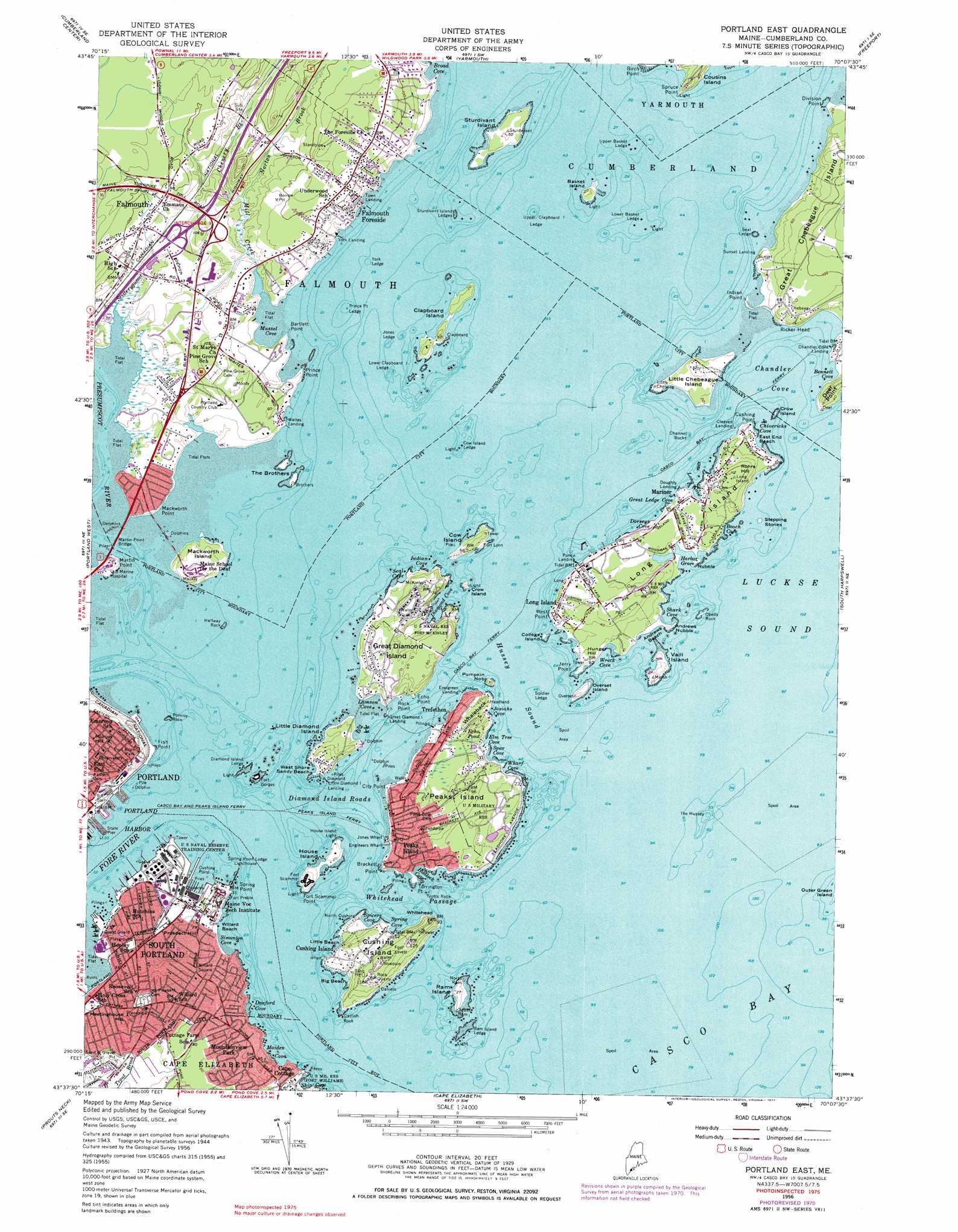
USGS Topo Quad 43070f2 - 1:24,000 scale
| Topo Map Name: | Portland East |
| USGS Topo Quad ID: | 43070f2 |
| Print Size: | ca. 21 1/4" wide x 27" high |
| Southeast Coordinates: | 43.625° N latitude / 70.125° W longitude |
| Map Center Coordinates: | 43.6875° N latitude / 70.1875° W longitude |
| U.S. State: | ME |
| Filename: | o43070f2.jpg |
| Download Map JPG Image: | Portland East topo map 1:24,000 scale |
| Map Type: | Topographic |
| Topo Series: | 7.5´ |
| Map Scale: | 1:24,000 |
| Source of Map Images: | United States Geological Survey (USGS) |
| Alternate Map Versions: |
Portland East ME 1944 Download PDF Buy paper map Portland East ME 1944, updated 1948 Download PDF Buy paper map Portland East ME 1956, updated 1958 Download PDF Buy paper map Portland East ME 1956, updated 1966 Download PDF Buy paper map Portland East ME 1956, updated 1971 Download PDF Buy paper map Portland East ME 1956, updated 1977 Download PDF Buy paper map Portland East ME 1956, updated 1977 Download PDF Buy paper map Portland East ME 2011 Download PDF Buy paper map Portland East ME 2014 Download PDF Buy paper map |
1:24,000 Topo Quads surrounding Portland East
Raymond |
Gray |
North Pownal |
Lisbon Falls South |
Brunswick |
North Windham |
Cumberland Center |
Yarmouth |
Freeport |
Orrs Island |
Gorham |
Portland West |
Portland East |
South Harpswell |
Bailey Island |
Old Orchard Beach |
Prouts Neck |
Cape Elizabeth |
||
Biddeford |
Biddeford Pool |
> Back to 43070e1 at 1:100,000 scale
> Back to 43070a1 at 1:250,000 scale
> Back to U.S. Topo Maps home
Portland East topo map: Gazetteer
Portland East: Bars
Catfish Rock elevation 0m 0′Channel Rocks elevation 0m 0′
Cow Island Ledge elevation 0m 0′
Diamond Island Ledge elevation 0m 0′
Halfway Rock elevation 0m 0′
Jones Ledge elevation 0m 0′
Lower Basket Ledge elevation 0m 0′
Lower Clapboard Island Ledge elevation 0m 0′
Mariner Ledge elevation 0m 0′
Pomroy Rock elevation 0m 0′
Ponce Ledge elevation 0m 0′
Prince Point Ledge elevation 0m 0′
Prince Point Ledge elevation 0m 0′
Ram Island Ledge elevation 0m 0′
Seal Ledge elevation 0m 0′
Soldier Ledge elevation 0m 0′
Sturdivant Island Ledges elevation 0m 0′
The Hussey elevation 0m 0′
Trotts Rock elevation 0m 0′
Underwood Ledge elevation 0m 0′
Upper Basket Ledge elevation 0m 0′
Upper Clapboard Island Ledge elevation 0m 0′
York Ledge elevation 0m 0′
Portland East: Bays
Beach Cove elevation 0m 0′Broad Cove elevation 0m 0′
Chandler Cove elevation 0m 0′
Chivericks Cove elevation 0m 0′
Danford Cove elevation 0m 0′
Diamond Cove elevation 0m 0′
Dorseys Cove elevation 0m 0′
Elm Tree Cove elevation 0m 0′
Great Ledge Cove elevation 1m 3′
Hadlock Cove elevation 0m 0′
Harbor Grace elevation -3m -10′
Hussey Sound elevation 0m 0′
Indian Cove elevation 0m 0′
Josiahs Cove elevation 0m 0′
Lamson Cove elevation 1m 3′
Long Cove elevation 1m 3′
Luckse Sound elevation 0m 0′
Maiden Cove elevation 0m 0′
Mussel Cove elevation 0m 0′
Seal Cove elevation 0m 0′
Shark Cove elevation 0m 0′
Ship Cove elevation 0m 0′
Simonton Cove elevation 0m 0′
Spar Cove elevation 0m 0′
Spicers Cove elevation 0m 0′
Spring Cove elevation 0m 0′
Wharf Cove elevation 1m 3′
Wreck Cove elevation 0m 0′
Portland East: Beaches
Andrews Beach elevation 2m 6′Big Beach elevation 0m 0′
Cliff House Beach elevation 1m 3′
East End Beach elevation 0m 0′
Little Beach elevation 0m 0′
West Shore Sandy Beach elevation -1m -4′
Willard Beach elevation 0m 0′
Portland East: Benches
Fish Point Ledge elevation 0m 0′Portland East: Bridges
Martin Point Bridge elevation 0m 0′Portland East: Capes
Andrews Nubble elevation 0m 0′Bartlett Point elevation 3m 9′
Bennett Cove elevation 0m 0′
Brackett Point elevation 6m 19′
City Point elevation 2m 6′
Cushing Point elevation 4m 13′
Cushing Point elevation 0m 0′
Deer Point elevation 19m 62′
Division Point elevation 0m 0′
Echo Point elevation 3m 9′
Fish Point elevation 1m 3′
Fort Scammel Point elevation 0m 0′
Indian Point elevation 0m 0′
Jerry Point elevation 0m 0′
Mackworth Point elevation 7m 22′
Martin Point elevation 14m 45′
Nubble elevation 1m 3′
Prince Point elevation 2m 6′
Ricker Head elevation 4m 13′
Rock Point elevation 5m 16′
Spring Point elevation 8m 26′
Spruce Point elevation 4m 13′
Torrington Point elevation 0m 0′
West Point elevation 10m 32′
Whaleback elevation 19m 62′
Whitehead elevation 32m 104′
Portland East: Channels
Diamond Island Pass elevation 0m 0′Diamond Island Roads elevation 0m 0′
Whitehead Passage elevation 0m 0′
Portland East: Crossings
Interchange 8 elevation 15m 49′Interchange 9 elevation 16m 52′
Portland East: Forests
Falmouth Town Forest elevation 28m 91′Portland East: Harbors
Portland Harbor elevation 0m 0′Portland East: Islands
Basket Island elevation 5m 16′Clapboard Island elevation 9m 29′
College Island elevation 0m 0′
College Island elevation 0m 0′
Cow Island elevation 11m 36′
Crow Island elevation 0m 0′
Crow Island elevation 12m 39′
Cushing Island elevation 18m 59′
Great Diamond Island elevation 10m 32′
Hog Island Ledge elevation 2m 6′
House Island elevation 6m 19′
Little Chebeague Island elevation 11m 36′
Little Diamond Island elevation 6m 19′
Long Island elevation 7m 22′
Mackworth Island elevation 15m 49′
Obeds Rock elevation 1m 3′
Overset Island elevation 8m 26′
Peaks Island elevation 28m 91′
Pumpkin Nob elevation 12m 39′
Ram Island elevation 8m 26′
Stepping Stones elevation 1m 3′
Sturdivant Island elevation 12m 39′
The Brothers elevation 0m 0′
Vaill Island elevation 5m 16′
Portland East: Lakes
Echo Pond elevation 13m 42′Portland East: Parks
Basket Island Preserve elevation 6m 19′First Civic Monument elevation 27m 88′
Fort Allen Park elevation 28m 91′
Fort McKinley Historic District elevation 7m 22′
Spring Point Shoreway elevation 0m 0′
Willard Square elevation 11m 36′
Portland East: Populated Places
Cape Cottage elevation 7m 22′Chandler Cove Landing elevation 0m 0′
Cleaves Landing elevation 0m 0′
Cushing Island elevation 12m 39′
Doughty Landing elevation 0m 0′
East End elevation 41m 134′
Evergreen Landing elevation 0m 0′
Falmouth elevation 26m 85′
Falmouth Foreside elevation 32m 104′
Ferry Village elevation 4m 13′
Fort Gorges elevation 1m 3′
Fort Levett elevation 35m 114′
Fort Lyon elevation 6m 19′
Fort Preble elevation 0m 0′
Fort Scammel elevation 21m 68′
Great Diamond Island Landing elevation 0m 0′
Jones Wharf elevation 0m 0′
Little Diamond Island Landing elevation 1m 3′
Long Island elevation 18m 59′
Loveitts Field elevation 25m 82′
Mariner elevation 7m 22′
McKinley Estates elevation 22m 72′
Meeting House Hill elevation 14m 45′
Mountainview Park elevation 30m 98′
Munjoy Hill elevation 46m 150′
Peaks Island elevation 21m 68′
Ponce Landing elevation 0m 0′
South Portland elevation 7m 22′
Sunset Landing elevation 7m 22′
Trefethen elevation 9m 29′
Waites Landing elevation 0m 0′
Willard Square elevation 15m 49′
York Landing elevation 0m 0′
Portland East: Post Offices
Peak Island Post Office (historical) elevation 9m 29′Portland East: Springs
Underwood Spring elevation 3m 9′Portland East: Streams
Chenery Brook elevation 4m 13′Fore River elevation 0m 0′
Kimball Brook elevation 5m 16′
Mill Creek elevation 4m 13′
Norton Brook elevation 4m 13′
Presumpscot River elevation 0m 0′
Scitterygusset Creek elevation 0m 0′
Trout Brook elevation 0m 0′
Portland East: Summits
Fort Hill elevation 14m 45′Hunger Hill elevation 11m 36′
Meetinghouse Hill elevation 31m 101′
Prospect Hill elevation 20m 65′
Rohrs Hill elevation 35m 114′
Portland East: Trails
Casco Bay Ferry elevation 0m 0′Peaks Island Ferry elevation 0m 0′
Portland East digital topo map on disk
Buy this Portland East topo map showing relief, roads, GPS coordinates and other geographical features, as a high-resolution digital map file on DVD:
Maine, New Hampshire, Rhode Island & Eastern Massachusetts
Buy digital topo maps: Maine, New Hampshire, Rhode Island & Eastern Massachusetts