Portland West Topo Map Maine
To zoom in, hover over the map of Portland West
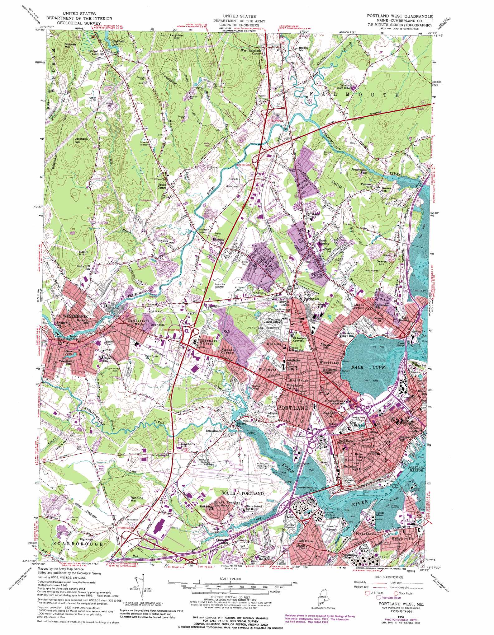
USGS Topo Quad 43070f3 - 1:24,000 scale
| Topo Map Name: | Portland West |
| USGS Topo Quad ID: | 43070f3 |
| Print Size: | ca. 21 1/4" wide x 27" high |
| Southeast Coordinates: | 43.625° N latitude / 70.25° W longitude |
| Map Center Coordinates: | 43.6875° N latitude / 70.3125° W longitude |
| U.S. State: | ME |
| Filename: | o43070f3.jpg |
| Download Map JPG Image: | Portland West topo map 1:24,000 scale |
| Map Type: | Topographic |
| Topo Series: | 7.5´ |
| Map Scale: | 1:24,000 |
| Source of Map Images: | United States Geological Survey (USGS) |
| Alternate Map Versions: |
Portland West ME 1944, updated 1948 Download PDF Buy paper map Portland West ME 1956, updated 1958 Download PDF Buy paper map Portland West ME 1956, updated 1970 Download PDF Buy paper map Portland West ME 1956, updated 1971 Download PDF Buy paper map Portland West ME 1956, updated 1978 Download PDF Buy paper map Portland West ME 1956, updated 1988 Download PDF Buy paper map Portland West ME 1956, updated 1988 Download PDF Buy paper map Portland West ME 2011 Download PDF Buy paper map Portland West ME 2014 Download PDF Buy paper map |
1:24,000 Topo Quads surrounding Portland West
Naples |
Raymond |
Gray |
North Pownal |
Lisbon Falls South |
Sebago Lake |
North Windham |
Cumberland Center |
Yarmouth |
Freeport |
Standish |
Gorham |
Portland West |
Portland East |
South Harpswell |
Bar Mills |
Old Orchard Beach |
Prouts Neck |
Cape Elizabeth |
|
Kennebunk |
Biddeford |
Biddeford Pool |
> Back to 43070e1 at 1:100,000 scale
> Back to 43070a1 at 1:250,000 scale
> Back to U.S. Topo Maps home
Portland West topo map: Gazetteer
Portland West: Airports
Portland International Jetport elevation 16m 52′Super Cub Field elevation 25m 82′
Portland West: Bays
Back Cove elevation 0m 0′Portland West: Bridges
Portland Bridge elevation 0m 0′Riverton Bridge elevation 9m 29′
Tukey Bridge elevation 0m 0′
Vaughans Bridge (historical) elevation 0m 0′
Veterans Memorial Bridge elevation 0m 0′
Portland West: Capes
Thompson Point elevation 0m 0′Portland West: Crossings
Interchange 10 elevation 25m 82′Interchange 3 elevation 11m 36′
Interchange 4 elevation 3m 9′
Interchange 5 elevation 4m 13′
Interchange 6 elevation 4m 13′
Interchange 6 elevation 20m 65′
Interchange 7 elevation 23m 75′
Interchange 7 elevation 4m 13′
Interchange 8 elevation 14m 45′
Portland West: Dams
Clark Pond Dam elevation 0m 0′Cumberland Dam elevation 13m 42′
Highland Lake Dam elevation 58m 190′
Saccarappa Dam elevation 18m 59′
Stroudwater Dam elevation 7m 22′
Portland West: Falls
Presumpscot Falls elevation 0m 0′Saccarappa Falls elevation 14m 45′
Portland West: Islands
Turner Island elevation 1m 3′Portland West: Lakes
Beaver Pond elevation 24m 78′Haskell Pond elevation 18m 59′
Rye Pond (historical) elevation 14m 45′
Portland West: Parks
Back Cove Historic District elevation 6m 19′Back Cove Park elevation 1m 3′
Baxter Pines elevation 18m 59′
Baxter Woods elevation 34m 111′
Boothby Square elevation 4m 13′
Congress Square Park elevation 33m 108′
Cumberland Mills Historic District elevation 13m 42′
Deering Oaks Park elevation 6m 19′
Deering Street Historic District elevation 31m 101′
Edward Payson Park elevation 6m 19′
Fore River Sanctuary elevation 18m 59′
Fort Allen Park elevation 27m 88′
Fort Sumner Park elevation 30m 98′
Hadlock Field elevation 10m 32′
Henry Wadsworth Longfellow Monument elevation 37m 121′
Hinckley Park elevation 20m 65′
Lincoln Park elevation 16m 52′
Longfellow Square elevation 37m 121′
Mill Creek Park elevation 3m 9′
Monument Square elevation 22m 72′
Neal Dow Memorial elevation 38m 124′
Portland Downtown Historic District elevation 18m 59′
Portland Stadium elevation 11m 36′
Portland Waterfront Historic District elevation 0m 0′
Post Office Plaza elevation 15m 49′
Presumpscot Park elevation 23m 75′
Spring Street Historic District elevation 36m 118′
Standpine Park elevation 47m 154′
Stroudwater Historic District elevation 6m 19′
Tommys Park elevation 17m 55′
Westbrook College Historic District elevation 38m 124′
Western Promenade elevation 18m 59′
Western Promenade Historic District elevation 49m 160′
Portland West: Populated Places
Bradleys Corner elevation 12m 39′Brighton Corner elevation 28m 91′
Cash Corner elevation 7m 22′
Crocketts Corner elevation 15m 49′
Cumberland Mills elevation 18m 59′
Deering elevation 32m 104′
Deering Junction elevation 32m 104′
East Deering elevation 8m 26′
Garrison Hills Estates elevation 0m 0′
Grubb Hill (historical) elevation 45m 147′
Highland Lake elevation 65m 213′
Highlands elevation 38m 124′
Knightville elevation 17m 55′
Libbytown elevation 7m 22′
Ligonia elevation 12m 39′
Lone Creek Village (historical) elevation 13m 42′
Lunts Corner elevation 19m 62′
Morrills Corner elevation 35m 114′
Nasons Corner elevation 19m 62′
North Deering elevation 25m 82′
Oakdale elevation 19m 62′
Pleasant Hill elevation 36m 118′
Pleasantdale elevation 7m 22′
Portland elevation 19m 62′
Prides Corner elevation 38m 124′
Riverton elevation 23m 75′
Rosemont elevation 12m 39′
Rosemont elevation 20m 65′
Sagamore Village elevation 24m 78′
South Portland Gardens elevation 15m 49′
Stroudwater elevation 15m 49′
Summit View Park (historical) elevation 53m 173′
Village of Halidon (historical) elevation 53m 173′
West End elevation 46m 150′
West Falmouth (historical) elevation 12m 39′
West Falmouth Corner elevation 41m 134′
Westbrook elevation 23m 75′
Woodfords elevation 12m 39′
Woodfords Corner elevation 17m 55′
Portland West: Post Offices
Portland Post Office elevation 16m 52′Westbrook Post Office (historical) elevation 21m 68′
Portland West: Reservoirs
Capisic Pond elevation 15m 49′Clark Pond elevation 0m 0′
Highland Lake elevation 58m 190′
Presumpscot River Reservoir elevation 13m 42′
Stroudwater River Reservoir elevation 7m 22′
Portland West: Streams
Anthoine Creek elevation 2m 6′Barberry Creek elevation 2m 6′
Beaver Pond Brook elevation 7m 22′
Clark Brook elevation 14m 45′
East Branch Piscataqua River elevation 7m 22′
Fall Brook elevation 4m 13′
Johnson Branch elevation 10m 32′
Long Creek elevation 0m 0′
Meader Brook elevation 7m 22′
Mill Brook elevation 7m 22′
Minnow Brook elevation 7m 22′
North Branch elevation 8m 26′
Piscataqua River elevation 7m 22′
Red Brook elevation 0m 0′
Small Brook elevation 39m 127′
Stroudwater River elevation 0m 0′
Portland West: Summits
Blackstrap Hill elevation 129m 423′Blueberry Hill elevation 37m 121′
Deer Hill elevation 45m 147′
Graves Hill elevation 52m 170′
Leighton Hill elevation 145m 475′
Lorenzen Hill elevation 94m 308′
Milliken Hill elevation 119m 390′
Pig Knoll elevation 51m 167′
Rocky Hill elevation 80m 262′
Rocky Hill elevation 49m 160′
Running Hill elevation 48m 157′
Thompson Hill elevation 45m 147′
Portland West: Swamps
The Heath elevation 68m 223′Portland West digital topo map on disk
Buy this Portland West topo map showing relief, roads, GPS coordinates and other geographical features, as a high-resolution digital map file on DVD:
Maine, New Hampshire, Rhode Island & Eastern Massachusetts
Buy digital topo maps: Maine, New Hampshire, Rhode Island & Eastern Massachusetts