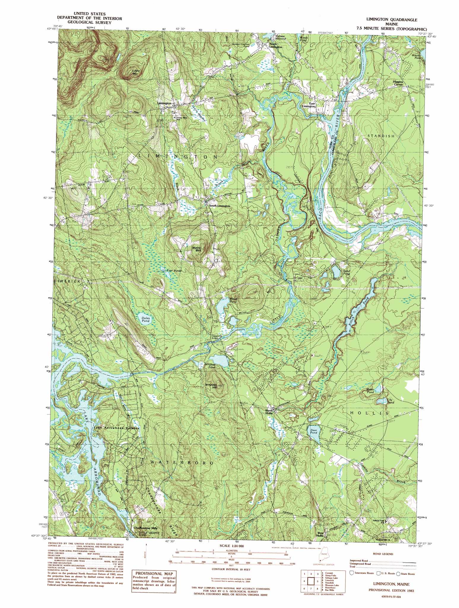
Limington Topo Map Maine
To zoom in, hover over the map of Limington
USGS Topo Quad 43070f6 - 1:24,000 scale
| Topo Map Name: | Limington |
| USGS Topo Quad ID: | 43070f6 |
| Print Size: | ca. 21 1/4" wide x 27" high |
| Southeast Coordinates: | 43.625° N latitude / 70.625° W longitude |
| Map Center Coordinates: | 43.6875° N latitude / 70.6875° W longitude |
| U.S. State: | ME |
| Filename: | o43070f6.jpg |
| Download Map JPG Image: | Limington topo map 1:24,000 scale |
| Map Type: | Topographic |
| Topo Series: | 7.5´ |
| Map Scale: | 1:24,000 |
| Source of Map Images: | United States Geological Survey (USGS) |
| Alternate Map Versions: |
Limington ME 1983, updated 1984 Download PDF Buy paper map Limington ME 1983, updated 1984 Download PDF Buy paper map Limington ME 2011 Download PDF Buy paper map Limington ME 2014 Download PDF Buy paper map |
1:24,000 Topo Quads surrounding Limington
Brownfield |
Hiram |
North Sebago |
Naples |
Raymond |
Kezar Falls |
Cornish |
Steep Falls |
Sebago Lake |
North Windham |
West Newfield |
Limerick |
Limington |
Standish |
Gorham |
Great East Lake |
Mousam Lake |
Waterboro |
Bar Mills |
Old Orchard Beach |
Milton |
Sanford |
Alfred |
Kennebunk |
Biddeford |
> Back to 43070e1 at 1:100,000 scale
> Back to 43070a1 at 1:250,000 scale
> Back to U.S. Topo Maps home
Limington topo map: Gazetteer
Limington: Bridges
Edgecomb Bridge elevation 84m 275′Limington: Dams
Ledgemere Dam elevation 87m 285′Little Ossipee Pond Dam elevation 93m 305′
North Limington Dam elevation 77m 252′
Watchic Pond Dam elevation 84m 275′
Limington: Lakes
Boyd Pond elevation 87m 285′Deer Pond elevation 90m 295′
Doles Pond elevation 90m 295′
Foss Ponds elevation 109m 357′
Isinglass Pond elevation 86m 282′
Killick Pond elevation 87m 285′
Lily Pond elevation 86m 282′
Sand Pond elevation 85m 278′
Wales Pond elevation 74m 242′
Limington: Populated Places
Chadbournes Mills elevation 93m 305′East Limington elevation 77m 252′
Higgins Corner elevation 100m 328′
Lake Arrowhead elevation 103m 337′
Lake Arrowhead Estates elevation 98m 321′
Limington elevation 147m 482′
North Hollis elevation 90m 295′
North Limington elevation 91m 298′
South Limington elevation 100m 328′
West Hollis elevation 114m 374′
Limington: Reservoirs
Lake Arrowhead elevation 87m 285′Little Ossipee Pond elevation 93m 305′
The Flowage Reservoir elevation 93m 305′
Watchic Pond elevation 84m 275′
Webster Millpond elevation 77m 252′
Limington: Streams
Black Brook elevation 76m 249′Brown Brook elevation 93m 305′
Hamlin Brook elevation 71m 232′
Horse Pond Brook elevation 78m 255′
Little Ossipee River elevation 66m 216′
Limington: Summits
Chadbournes Ridge elevation 168m 551′Isinglass Hill elevation 126m 413′
Libby Mountain elevation 247m 810′
Maloy Mountain elevation 182m 597′
Limington: Swamps
Swetts Meadow elevation 118m 387′Limington digital topo map on disk
Buy this Limington topo map showing relief, roads, GPS coordinates and other geographical features, as a high-resolution digital map file on DVD:
Maine, New Hampshire, Rhode Island & Eastern Massachusetts
Buy digital topo maps: Maine, New Hampshire, Rhode Island & Eastern Massachusetts