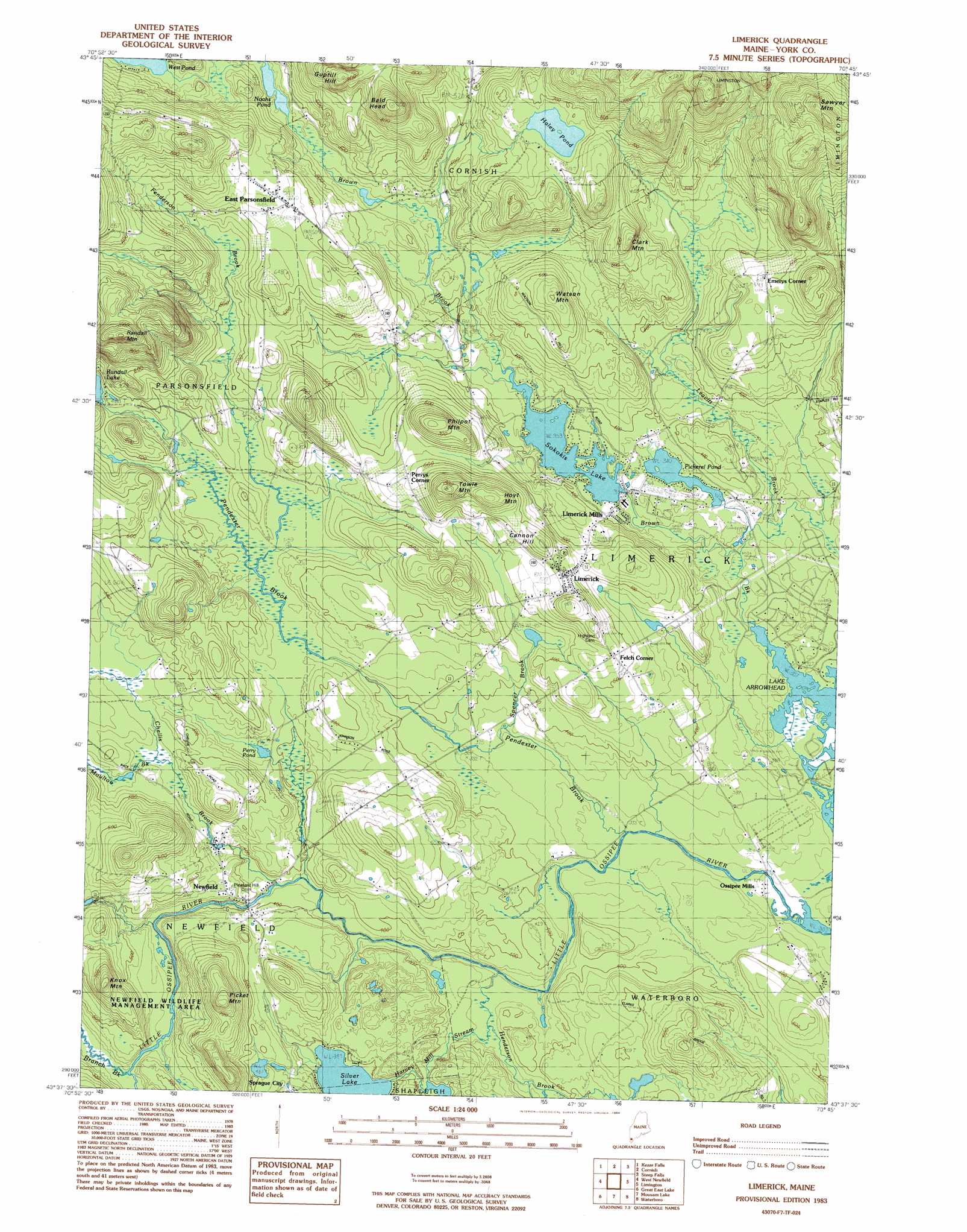
Limerick Topo Map Maine
To zoom in, hover over the map of Limerick
USGS Topo Quad 43070f7 - 1:24,000 scale
| Topo Map Name: | Limerick |
| USGS Topo Quad ID: | 43070f7 |
| Print Size: | ca. 21 1/4" wide x 27" high |
| Southeast Coordinates: | 43.625° N latitude / 70.75° W longitude |
| Map Center Coordinates: | 43.6875° N latitude / 70.8125° W longitude |
| U.S. State: | ME |
| Filename: | o43070f7.jpg |
| Download Map JPG Image: | Limerick topo map 1:24,000 scale |
| Map Type: | Topographic |
| Topo Series: | 7.5´ |
| Map Scale: | 1:24,000 |
| Source of Map Images: | United States Geological Survey (USGS) |
| Alternate Map Versions: |
Limerick ME 1983, updated 1984 Download PDF Buy paper map Limerick ME 1983, updated 1984 Download PDF Buy paper map Limerick ME 2011 Download PDF Buy paper map Limerick ME 2014 Download PDF Buy paper map |
1:24,000 Topo Quads surrounding Limerick
Conway |
Brownfield |
Hiram |
North Sebago |
Naples |
Freedom |
Kezar Falls |
Cornish |
Steep Falls |
Sebago Lake |
Ossipee |
West Newfield |
Limerick |
Limington |
Standish |
Sanbornville |
Great East Lake |
Mousam Lake |
Waterboro |
Bar Mills |
Farmington |
Milton |
Sanford |
Alfred |
Kennebunk |
> Back to 43070e1 at 1:100,000 scale
> Back to 43070a1 at 1:250,000 scale
> Back to U.S. Topo Maps home
Limerick topo map: Gazetteer
Limerick: Bridges
Clarks Bridge elevation 109m 357′Limerick: Dams
Sokokis Lake Dam elevation 108m 354′Symmes Pond Dam elevation 150m 492′
Limerick: Lakes
Haley Ponds elevation 203m 666′Noahs Pond elevation 146m 479′
Pickerel Pond elevation 103m 337′
Silver Lake elevation 118m 387′
Limerick: Parks
Newfield Historic District elevation 135m 442′Limerick: Populated Places
East Parsonsfield elevation 196m 643′Emerys Corner elevation 179m 587′
Felch Corner elevation 162m 531′
Limerick elevation 166m 544′
Limerick Mills elevation 118m 387′
Newfield elevation 119m 390′
Ossipee Mills elevation 98m 321′
Perrys Corner elevation 179m 587′
Sprague City elevation 144m 472′
Limerick: Reservoirs
Perry Pond elevation 125m 410′Sokokis Lake elevation 108m 354′
Symmes Pond elevation 150m 492′
Limerick: Streams
Benson Brook elevation 139m 456′Branch Brook elevation 123m 403′
Buff Brook elevation 107m 351′
Chellis Brook elevation 116m 380′
Fenderson Brook elevation 130m 426′
Harvey Mill Stream elevation 103m 337′
Leavitt Brook elevation 96m 314′
Moulton Brook elevation 132m 433′
Pendexter Brook elevation 99m 324′
Spencer Brook elevation 109m 357′
Limerick: Summits
Bald Head elevation 299m 980′Cannon Hill elevation 201m 659′
Clark Mountain elevation 240m 787′
Guptill Hill elevation 272m 892′
Hoyt Mountain elevation 237m 777′
Knox Mountain elevation 236m 774′
Philpot Mountain elevation 231m 757′
Picket Mountain elevation 249m 816′
Randall Mountain elevation 311m 1020′
Sawyer Mountain elevation 365m 1197′
Towle Mountain elevation 256m 839′
Watson Mountain elevation 208m 682′
Limerick digital topo map on disk
Buy this Limerick topo map showing relief, roads, GPS coordinates and other geographical features, as a high-resolution digital map file on DVD:
Maine, New Hampshire, Rhode Island & Eastern Massachusetts
Buy digital topo maps: Maine, New Hampshire, Rhode Island & Eastern Massachusetts