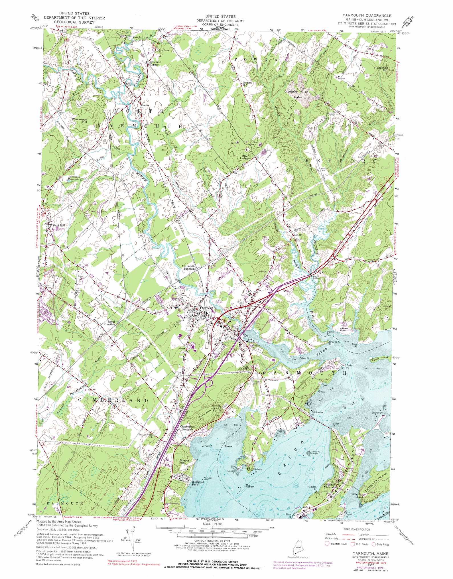
Yarmouth Topo Map Maine
To zoom in, hover over the map of Yarmouth
USGS Topo Quad 43070g2 - 1:24,000 scale
| Topo Map Name: | Yarmouth |
| USGS Topo Quad ID: | 43070g2 |
| Print Size: | ca. 21 1/4" wide x 27" high |
| Southeast Coordinates: | 43.75° N latitude / 70.125° W longitude |
| Map Center Coordinates: | 43.8125° N latitude / 70.1875° W longitude |
| U.S. State: | ME |
| Filename: | o43070g2.jpg |
| Download Map JPG Image: | Yarmouth topo map 1:24,000 scale |
| Map Type: | Topographic |
| Topo Series: | 7.5´ |
| Map Scale: | 1:24,000 |
| Source of Map Images: | United States Geological Survey (USGS) |
| Alternate Map Versions: |
Yarmouth ME 1957, updated 1959 Download PDF Buy paper map Yarmouth ME 1957, updated 1971 Download PDF Buy paper map Yarmouth ME 1957, updated 1977 Download PDF Buy paper map Yarmouth ME 2011 Download PDF Buy paper map Yarmouth ME 2014 Download PDF Buy paper map |
1:24,000 Topo Quads surrounding Yarmouth
Mechanic Falls |
Minot |
Lewiston |
Lisbon Falls North |
Bowdoinham |
Raymond |
Gray |
North Pownal |
Lisbon Falls South |
Brunswick |
North Windham |
Cumberland Center |
Yarmouth |
Freeport |
Orrs Island |
Gorham |
Portland West |
Portland East |
South Harpswell |
Bailey Island |
Old Orchard Beach |
Prouts Neck |
Cape Elizabeth |
> Back to 43070e1 at 1:100,000 scale
> Back to 43070a1 at 1:250,000 scale
> Back to U.S. Topo Maps home
Yarmouth topo map: Gazetteer
Yarmouth: Areas
Desert of Maine elevation 34m 111′Yarmouth: Bars
Anderson Rock elevation 0m 0′Sandy Point Ledges elevation 0m 0′
Yarmouth: Bays
Broad Cove elevation 0m 0′Dead Mans Cove elevation 0m 0′
White Cove elevation 13m 42′
Yarmouth: Benches
The Ledges elevation 63m 206′Yarmouth: Capes
Birch Point elevation 2m 6′Blaney Point elevation 0m 0′
Browns Point elevation 10m 32′
Callen Point elevation 2m 6′
Doyle Point elevation 16m 52′
Drinkwater Point elevation 6m 19′
Fogg Point elevation 5m 16′
Lambert Point elevation 8m 26′
Madelon Point elevation 0m 0′
Parker Point elevation 5m 16′
Powell Point elevation 2m 6′
Prince Point elevation 8m 26′
Rock Ledge elevation 40m 131′
Sandy Point elevation 9m 29′
Sunset Point elevation 0m 0′
Yarmouth: Crossings
Interchange 16 elevation 29m 95′Interchange 17 elevation 41m 134′
Interchange 18 elevation 19m 62′
Mitchell Hill elevation 6m 19′
Yarmouth: Dams
Bridge Street Dam elevation 7m 22′East Elm Street Dam elevation 19m 62′
Yarmouth: Islands
Cousins Island elevation 22m 72′Lanes Island elevation 3m 9′
Littlejohn Island elevation 18m 59′
The Nubbin elevation 0m 0′
Yarmouth: Parks
Royal River Park elevation 24m 78′Wildwood Park elevation 14m 45′
Yarmouth: Populated Places
Cousins Island elevation 19m 62′Crockett Corner elevation 36m 118′
Cumberland Foreside elevation 20m 65′
Dunns elevation 30m 98′
Littlejohn Island elevation 5m 16′
Lower Village (historical) elevation 26m 85′
Royal Junction elevation 24m 78′
Sodom elevation 22m 72′
Todds Corners elevation 34m 111′
Upper Village (historical) elevation 39m 127′
Walnut Hill elevation 62m 203′
Yarmouth elevation 24m 78′
Yarmouth Junction elevation 26m 85′
Yarmouth: Post Offices
North Yarmouth Post Office (historical) elevation 30m 98′Yarmouth: Reservoirs
Royal River Reservoir elevation 24m 78′Royal River Reservoir elevation 7m 22′
Yarmouth Reservoir elevation 36m 118′
Yarmouth: Streams
Chandler Brook elevation 20m 65′Cousins River elevation 0m 0′
East Branch Chandler Brook elevation 20m 65′
Harvey Brook elevation 3m 9′
Lambert Point Stream elevation 0m 0′
Maxfield Brook elevation 18m 59′
Merrill Brook elevation 3m 9′
Mill Brook elevation 12m 39′
Pratts Brook elevation 1m 3′
Roddings Creek elevation 0m 0′
Royal River elevation 0m 0′
Toddy Brook elevation 20m 65′
Windle Brook elevation 18m 59′
Yarmouth: Summits
Hedgehog Mountain elevation 85m 278′Mitchell Hill elevation 57m 187′
Spears Hill elevation 57m 187′
Sturdivant Hill elevation 52m 170′
Sturdivant Hill elevation 49m 160′
Trues Hill elevation 30m 98′
Wescutogo Hill elevation 76m 249′
York Hill elevation 66m 216′
Yarmouth digital topo map on disk
Buy this Yarmouth topo map showing relief, roads, GPS coordinates and other geographical features, as a high-resolution digital map file on DVD:
Maine, New Hampshire, Rhode Island & Eastern Massachusetts
Buy digital topo maps: Maine, New Hampshire, Rhode Island & Eastern Massachusetts