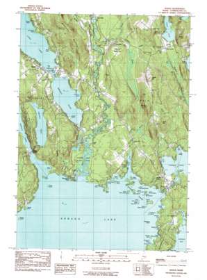
Naples Topo Map Maine
To zoom in, hover over the map of Naples
USGS Topo Quad 43070h5 - 1:24,000 scale
| Topo Map Name: | Naples |
| USGS Topo Quad ID: | 43070h5 |
| Print Size: | ca. 21 1/4" wide x 27" high |
| Southeast Coordinates: | 43.875° N latitude / 70.5° W longitude |
| Map Center Coordinates: | 43.9375° N latitude / 70.5625° W longitude |
| U.S. State: | ME |
| Filename: | o43070h5.jpg |
| Download Map JPG Image: | Naples topo map 1:24,000 scale |
| Map Type: | Topographic |
| Topo Series: | 7.5´ |
| Map Scale: | 1:24,000 |
| Source of Map Images: | United States Geological Survey (USGS) |
| Alternate Map Versions: |
Naples ME 1983, updated 1984 Download PDF Buy paper map Naples ME 1983, updated 1984 Download PDF Buy paper map Naples ME 1983, updated 1984 Download PDF Buy paper map Naples ME 2011 Download PDF Buy paper map Naples ME 2014 Download PDF Buy paper map |
1:24,000 Topo Quads surrounding Naples
> Back to 43070e1 at 1:100,000 scale
> Back to 43070a1 at 1:250,000 scale
> Back to U.S. Topo Maps home
Naples topo map: Gazetteer
Naples: Airports
Naples Seaplane Base elevation 82m 269′Naples: Bays
Burnell Cove elevation 81m 265′Cub Cove elevation 81m 265′
Flag Cove elevation 85m 278′
Jackson Cove elevation 82m 269′
Kettle Cove elevation 81m 265′
Lower Harvey Cove elevation 81m 265′
Maple Cove elevation 81m 265′
New Place Cove elevation 81m 265′
Schooner Cove elevation 81m 265′
Sebago Cove elevation 81m 265′
Shingle Cove elevation 82m 269′
Turtle Cove elevation 87m 285′
Upper Harvey Cove elevation 81m 265′
Witch Cove elevation 81m 265′
Naples: Capes
Arrowhead Point elevation 83m 272′Bear Point elevation 83m 272′
Birch Point elevation 82m 269′
Breezy Point elevation 82m 269′
Cub Point elevation 82m 269′
Kelseys Point elevation 85m 278′
Keoka Point elevation 82m 269′
Thompson Point elevation 82m 269′
Wards Point elevation 81m 265′
Naples: Channels
Chute River elevation 82m 269′Naples: Dams
Songo Lock Dam elevation 81m 265′Thomas Pond Dam elevation 85m 278′
Naples: Islands
Battleship Island elevation 81m 265′Birch Island elevation 81m 265′
Blueberry Island elevation 81m 265′
Dingley Islands elevation 85m 278′
Doctor Island elevation 81m 265′
Inner Birch Island elevation 81m 265′
Inner Green Island elevation 85m 278′
Inner Island elevation 81m 265′
Inner Spectacle Island elevation 81m 265′
Inner Twin Island elevation 81m 265′
Lpon Island elevation 85m 278′
Millstone Island elevation 81m 265′
Outer Birch Island elevation 83m 272′
Outer Doctor Island elevation 81m 265′
Outer Green Island elevation 84m 275′
Outer Island elevation 81m 265′
Outer Spectacle Island elevation 81m 265′
Outer Twin Island elevation 81m 265′
Ring Island elevation 86m 282′
Rookies Island elevation 82m 269′
Sheep Island elevation 81m 265′
Spider Island elevation 81m 265′
Naples: Lakes
Brandy Pond elevation 82m 269′Owl Pond elevation 160m 524′
Parker Pond elevation 130m 426′
Trickey Pond elevation 108m 354′
Naples: Parks
Sebago Lake State Park elevation 82m 269′Naples: Populated Places
Cook Mills elevation 99m 324′Edes Falls elevation 98m 321′
Naples elevation 86m 282′
Pike Corner elevation 137m 449′
Songo Lock elevation 85m 278′
South Casco elevation 96m 314′
South Naples elevation 93m 305′
Naples: Reservoirs
Bay of Naples elevation 87m 285′Thomas Pond elevation 85m 278′
Naples: Streams
Bartlett Brook elevation 85m 278′Crooked River elevation 82m 269′
Decker Brook elevation 90m 295′
Dingley Brook elevation 81m 265′
Dingley Brook elevation 81m 265′
Leavitt Brook elevation 81m 265′
Mill Brook elevation 84m 275′
Songo River elevation 81m 265′
Whitney Brook elevation 82m 269′
Naples: Summits
Barton Hill elevation 233m 764′Leach Hill elevation 186m 610′
Mitchell Hill elevation 190m 623′
Quaker Hill elevation 228m 748′
Tenny Hill elevation 131m 429′
Naples digital topo map on disk
Buy this Naples topo map showing relief, roads, GPS coordinates and other geographical features, as a high-resolution digital map file on DVD:
Maine, New Hampshire, Rhode Island & Eastern Massachusetts
Buy digital topo maps: Maine, New Hampshire, Rhode Island & Eastern Massachusetts


