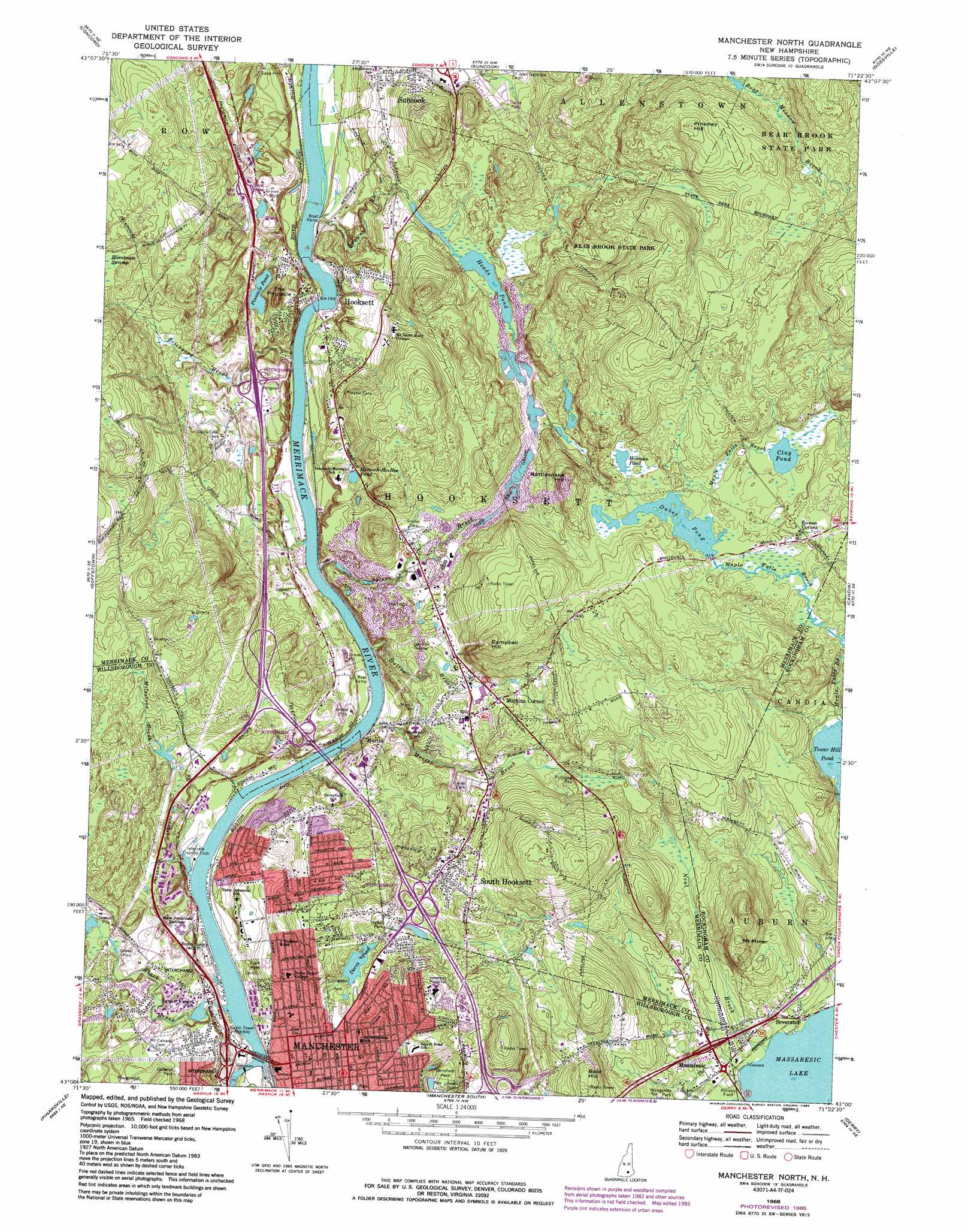
Manchester North Topo Map New Hampshire
To zoom in, hover over the map of Manchester North
USGS Topo Quad 43071a4 - 1:24,000 scale
| Topo Map Name: | Manchester North |
| USGS Topo Quad ID: | 43071a4 |
| Print Size: | ca. 21 1/4" wide x 27" high |
| Southeast Coordinates: | 43° N latitude / 71.375° W longitude |
| Map Center Coordinates: | 43.0625° N latitude / 71.4375° W longitude |
| U.S. State: | NH |
| Filename: | o43071a4.jpg |
| Download Map JPG Image: | Manchester North topo map 1:24,000 scale |
| Map Type: | Topographic |
| Topo Series: | 7.5´ |
| Map Scale: | 1:24,000 |
| Source of Map Images: | United States Geological Survey (USGS) |
| Alternate Map Versions: |
Manchester North NH 1968, updated 1971 Download PDF Buy paper map Manchester North NH 1968, updated 1983 Download PDF Buy paper map Manchester North NH 1968, updated 1985 Download PDF Buy paper map Manchester North NH 1977, updated 1981 Download PDF Buy paper map Manchester North NH 2012 Download PDF Buy paper map Manchester North NH 2015 Download PDF Buy paper map |
1:24,000 Topo Quads surrounding Manchester North
Webster |
Penacook |
Loudon |
Pittsfield |
Parker Mountain |
Hopkinton |
Concord |
Suncook |
Gossville |
Northwood |
Weare |
Goffstown |
Manchester North |
Candia |
Mount Pawtuckaway |
New Boston |
Pinardville |
Manchester South |
Derry |
Sandown |
Milford |
South Merrimack |
Nashua North |
Windham |
> Back to 43071a1 at 1:100,000 scale
> Back to 43070a1 at 1:250,000 scale
> Back to U.S. Topo Maps home
Manchester North topo map: Gazetteer
Manchester North: Airports
Breaults River Side Seaplane Base elevation 53m 173′Hooksett-Manchester Airport elevation 91m 298′
Public Service Company Manchester Heliport elevation 54m 177′
Manchester North: Bridges
Amoskeag Bridge elevation 53m 173′Manchester North: Crossings
Interchange 1 elevation 91m 298′Interchange 10 elevation 74m 242′
Interchange 11 elevation 91m 298′
Interchange 5 elevation 59m 193′
Interchange 6 elevation 49m 160′
Interchange 8 elevation 115m 377′
Interchange 8 elevation 88m 288′
Interchange 9 elevation 107m 351′
Manchester North: Dams
Amoskeag Dam elevation 39m 127′Black Brook Dam elevation 121m 396′
Dorrs Pond Dam elevation 86m 282′
Dubes Pond Dam elevation 128m 419′
Goldfish Pond Dam elevation 100m 328′
Heads Pond Dam elevation 96m 314′
High Service Distribution Reservoir Dam elevation 153m 501′
Hooksett Dam elevation 56m 183′
Island Pond Dam elevation 61m 200′
Oak Hill Reservoir Dam elevation 137m 449′
Manchester North: Lakes
Clay Pond elevation 133m 436′Hannah-Ho-Hee Pond elevation 81m 265′
Hinman Pond elevation 130m 426′
Pinnacle Pond elevation 74m 242′
Manchester North: Parks
Black Brook Park elevation 74m 242′Cullerot Park elevation 82m 269′
Donati Memorial Field elevation 75m 246′
Livingston Park elevation 81m 265′
Samuel Blodget Park elevation 63m 206′
Stark Park elevation 76m 249′
Youngsville Park elevation 83m 272′
Manchester North: Populated Places
Hooksett elevation 64m 209′Martin elevation 57m 187′
Martins Corner elevation 100m 328′
Massabesic elevation 82m 269′
Rowes Corner elevation 140m 459′
Severance elevation 83m 272′
South Hooksett elevation 134m 439′
Manchester North: Reservoirs
Black Brook Pond elevation 121m 396′Dorrs Pond elevation 86m 282′
Dubes Pond elevation 128m 419′
Goldfish Pond elevation 100m 328′
Heads Pond elevation 93m 305′
Island Pond elevation 61m 200′
Merrimack River Reservoir elevation 56m 183′
Merrimack River Reservoir elevation 51m 167′
Oak Hill Reservoir elevation 137m 449′
Oak Hill Reservoir elevation 153m 501′
Stevens Pond elevation 100m 328′
Manchester North: Streams
Black Brook elevation 53m 173′Brickyard Brook elevation 58m 190′
Browns Brook elevation 56m 183′
Dalton Brook elevation 53m 173′
Messer Brook elevation 53m 173′
Milestone Brook elevation 53m 173′
Moose Meadow Brook elevation 126m 413′
Peters Brook elevation 53m 173′
Manchester North: Summits
Bald Hill elevation 166m 544′Campbell Hill elevation 169m 554′
Mount Miner elevation 171m 561′
Pinkney Hill elevation 203m 666′
Rattlesnake Hill elevation 160m 524′
The Pinnacle elevation 123m 403′
Manchester North digital topo map on disk
Buy this Manchester North topo map showing relief, roads, GPS coordinates and other geographical features, as a high-resolution digital map file on DVD:
Maine, New Hampshire, Rhode Island & Eastern Massachusetts
Buy digital topo maps: Maine, New Hampshire, Rhode Island & Eastern Massachusetts