Suncook Topo Map New Hampshire
To zoom in, hover over the map of Suncook
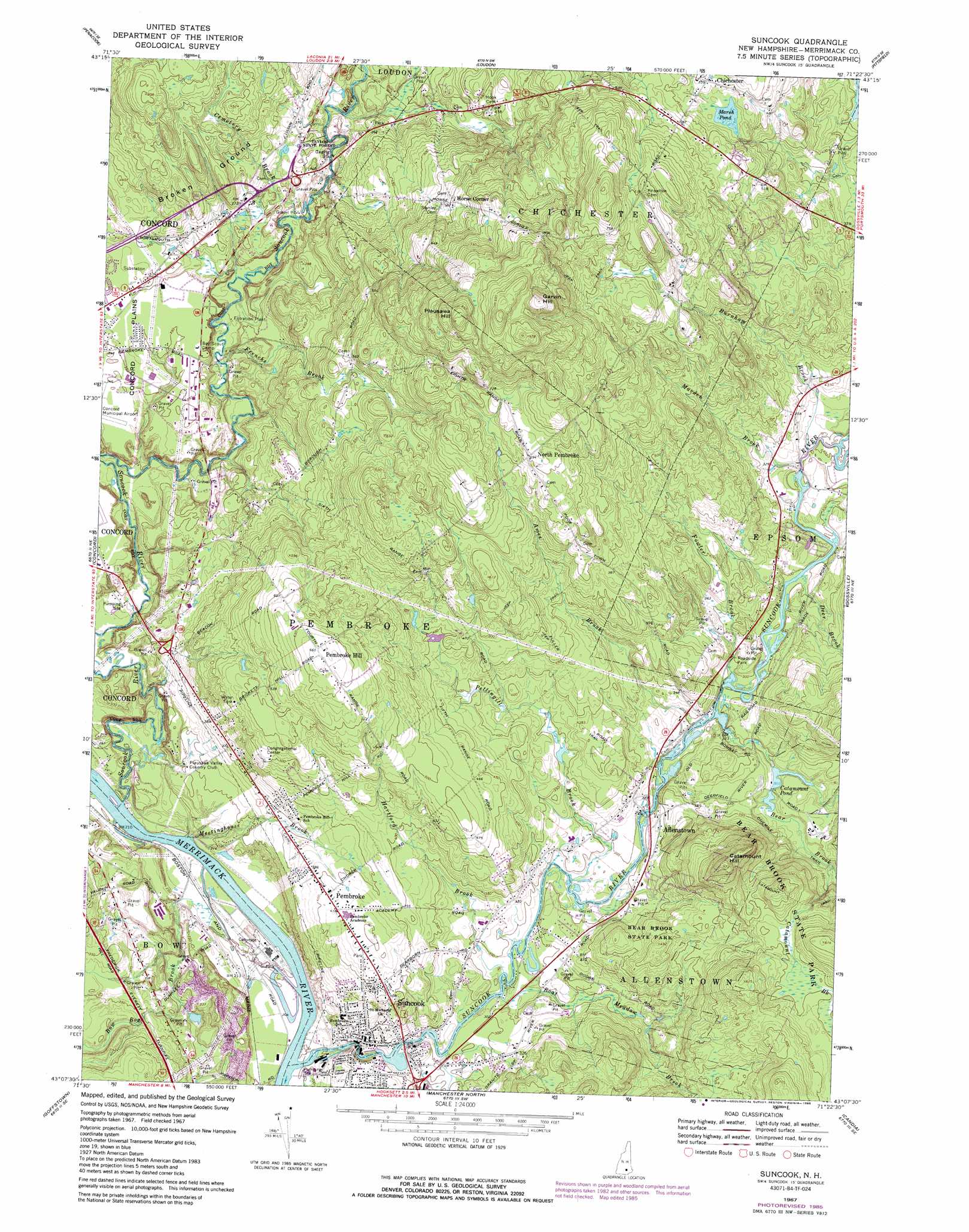
USGS Topo Quad 43071b4 - 1:24,000 scale
| Topo Map Name: | Suncook |
| USGS Topo Quad ID: | 43071b4 |
| Print Size: | ca. 21 1/4" wide x 27" high |
| Southeast Coordinates: | 43.125° N latitude / 71.375° W longitude |
| Map Center Coordinates: | 43.1875° N latitude / 71.4375° W longitude |
| U.S. State: | NH |
| Filename: | o43071b4.jpg |
| Download Map JPG Image: | Suncook topo map 1:24,000 scale |
| Map Type: | Topographic |
| Topo Series: | 7.5´ |
| Map Scale: | 1:24,000 |
| Source of Map Images: | United States Geological Survey (USGS) |
| Alternate Map Versions: |
Suncook NH 1967, updated 1971 Download PDF Buy paper map Suncook NH 1967, updated 1985 Download PDF Buy paper map Suncook NH 1967, updated 1985 Download PDF Buy paper map Suncook NH 2012 Download PDF Buy paper map Suncook NH 2015 Download PDF Buy paper map |
1:24,000 Topo Quads surrounding Suncook
Franklin |
Northfield |
Belmont |
Gilmanton Ironworks |
Alton |
Webster |
Penacook |
Loudon |
Pittsfield |
Parker Mountain |
Hopkinton |
Concord |
Suncook |
Gossville |
Northwood |
Weare |
Goffstown |
Manchester North |
Candia |
Mount Pawtuckaway |
New Boston |
Pinardville |
Manchester South |
Derry |
Sandown |
> Back to 43071a1 at 1:100,000 scale
> Back to 43070a1 at 1:250,000 scale
> Back to U.S. Topo Maps home
Suncook topo map: Gazetteer
Suncook: Airports
Brigham Heliport elevation 108m 354′PSNH Heliport elevation 64m 209′
Waste Heliport elevation 103m 337′
Suncook: Dams
Bear Brook State Park Dam elevation 96m 314′Buck Street East Dam elevation 88m 288′
Buck Street West Dam elevation 92m 301′
China Dam elevation 67m 219′
Old Reservoir Dam elevation 142m 465′
Pembroke Dam elevation 81m 265′
Saw Mill Dam Breeched elevation 95m 311′
Webster Dam elevation 93m 305′
Suncook: Forests
Taylor State Forest elevation 103m 337′Suncook: Lakes
Catamount Pond elevation 94m 308′Marsh Pond elevation 158m 518′
Spectacle Ponds elevation 73m 239′
Spectacle Ponds (historical) elevation 73m 239′
Suncook: Parks
Webster Park elevation 91m 298′Suncook: Populated Places
Allenstown Elementary School elevation 96m 314′Chichester elevation 164m 538′
Horse Corner elevation 185m 606′
North Pembroke elevation 212m 695′
Pembroke elevation 128m 419′
Suncook elevation 82m 269′
Suncook: Reservoirs
Bear Brook Park Pond elevation 96m 314′Old Pembroke Reservoir elevation 142m 465′
Saw Mill Pond elevation 95m 311′
Suncook River Reservoir elevation 93m 305′
Suncook River Reservoir elevation 81m 265′
Suncook River Reservoir elevation 67m 219′
Suncook River Reservoir elevation 88m 288′
Suncook River Reservoir elevation 92m 301′
Suncook: Streams
Ames Brook elevation 90m 295′Bear Brook elevation 88m 288′
Boat Meadow Brook elevation 88m 288′
Bow Bog Brook elevation 62m 203′
Burnham Brook elevation 91m 298′
Catamount Brook elevation 98m 321′
Cemetery Brook elevation 88m 288′
Deer Brook elevation 91m 298′
Fowler Brook elevation 88m 288′
Frenchs Brook elevation 83m 272′
Hartford Brook elevation 87m 285′
Little Bear Brook elevation 94m 308′
Marden Brook elevation 91m 298′
Meetinghouse Brook elevation 61m 200′
Pettingill Brook elevation 88m 288′
Soucook River elevation 61m 200′
Suncook River elevation 59m 193′
Suncook: Summits
Broken Ground elevation 145m 475′Catamount Hill elevation 219m 718′
Garvin Hill elevation 299m 980′
Pembroke Hill elevation 204m 669′
Plausawa Hill elevation 304m 997′
Suncook: Trails
Onemile Trail elevation 99m 324′Suncook digital topo map on disk
Buy this Suncook topo map showing relief, roads, GPS coordinates and other geographical features, as a high-resolution digital map file on DVD:
Maine, New Hampshire, Rhode Island & Eastern Massachusetts
Buy digital topo maps: Maine, New Hampshire, Rhode Island & Eastern Massachusetts