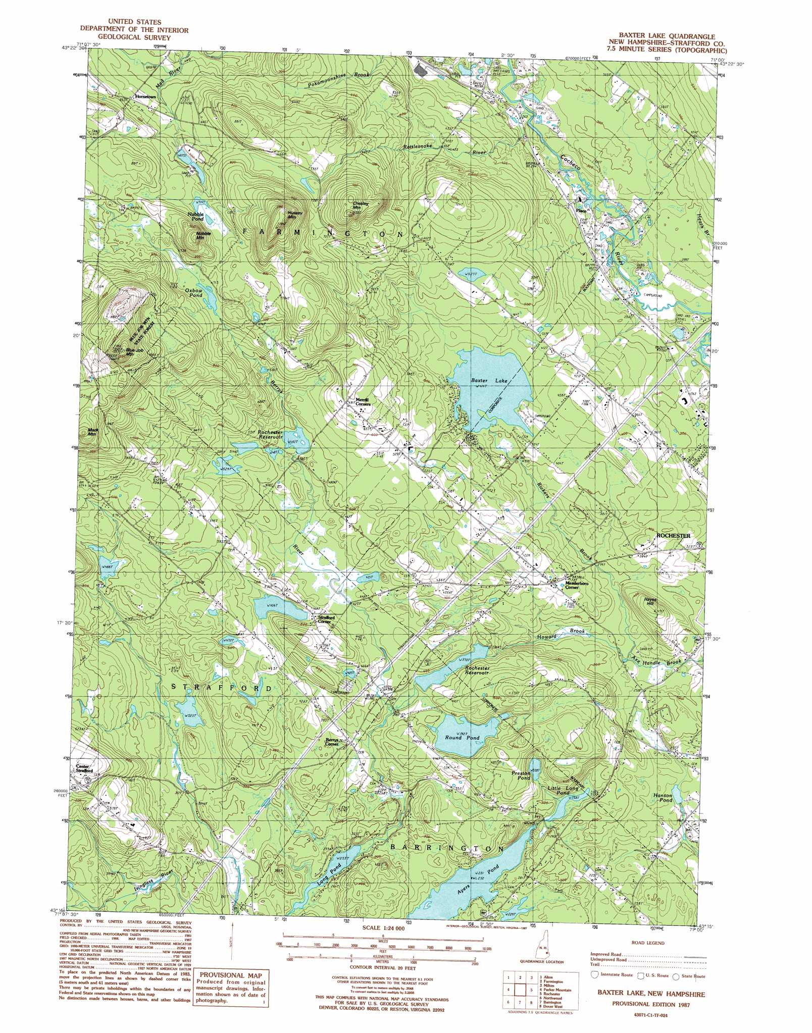
Baxter Lake Topo Map New Hampshire
To zoom in, hover over the map of Baxter Lake
USGS Topo Quad 43071c1 - 1:24,000 scale
| Topo Map Name: | Baxter Lake |
| USGS Topo Quad ID: | 43071c1 |
| Print Size: | ca. 21 1/4" wide x 27" high |
| Southeast Coordinates: | 43.25° N latitude / 71° W longitude |
| Map Center Coordinates: | 43.3125° N latitude / 71.0625° W longitude |
| U.S. State: | NH |
| Filename: | o43071c1.jpg |
| Download Map JPG Image: | Baxter Lake topo map 1:24,000 scale |
| Map Type: | Topographic |
| Topo Series: | 7.5´ |
| Map Scale: | 1:24,000 |
| Source of Map Images: | United States Geological Survey (USGS) |
| Alternate Map Versions: |
Baxter Lake NH 1987, updated 1987 Download PDF Buy paper map Baxter Lake NH 1987, updated 1987 Download PDF Buy paper map Baxter Lake NH 2012 Download PDF Buy paper map Baxter Lake NH 2015 Download PDF Buy paper map |
1:24,000 Topo Quads surrounding Baxter Lake
West Alton |
Wolfeboro |
Sanbornville |
Great East Lake |
Mousam Lake |
Gilmanton Ironworks |
Alton |
Farmington |
Milton |
Sanford |
Pittsfield |
Parker Mountain |
Baxter Lake |
Rochester |
Somersworth |
Gossville |
Northwood |
Barrington |
Dover West |
Dover East |
Candia |
Mount Pawtuckaway |
Epping |
Newmarket |
Portsmouth |
> Back to 43071a1 at 1:100,000 scale
> Back to 43070a1 at 1:250,000 scale
> Back to U.S. Topo Maps home
Baxter Lake topo map: Gazetteer
Baxter Lake: Dams
Baxter Lake Center Dike elevation 126m 413′Baxter Lake Easterly Dike elevation 127m 416′
Baxter Lake Main Dam elevation 129m 423′
Berry Brook Dam elevation 146m 479′
Berrys River Dam elevation 101m 331′
Kenneth Hill Dam elevation 101m 331′
Nubble Pond Brook Dam elevation 206m 675′
Preston Pond Dam elevation 101m 331′
Rochester Reservoir Dam elevation 110m 360′
Round Pond Dam elevation 116m 380′
Baxter Lake: Forests
Blue Job Mountain State Forest elevation 199m 652′Baxter Lake: Lakes
Little Long Pond elevation 77m 252′Long Pond elevation 79m 259′
Oxbow Pond elevation 221m 725′
Round Pond elevation 119m 390′
Baxter Lake: Populated Places
Berrys Corner elevation 110m 360′Hornetown elevation 199m 652′
Meaderboro Corner elevation 118m 387′
Merrill Corners elevation 207m 679′
Place elevation 82m 269′
Strafford Corner elevation 145m 475′
Baxter Lake: Reservoirs
Baxter Lake elevation 129m 423′Berrys River Reservoir elevation 101m 331′
Berrys River Reservoir elevation 146m 479′
Hanson Pond elevation 61m 200′
Kenneth Hill Pond elevation 101m 331′
Nubble Pond elevation 225m 738′
Preston Pond elevation 101m 331′
Rattlesnake Pond elevation 217m 711′
Rochester Reservoir elevation 110m 360′
Baxter Lake: Streams
Berrys River elevation 77m 252′Howard Brook elevation 73m 239′
Rickers Brook elevation 73m 239′
Baxter Lake: Summits
Blue Job Mountain elevation 395m 1295′Chesley Mountain elevation 311m 1020′
Hayes Hill elevation 130m 426′
Hussey Mountain elevation 350m 1148′
Mack Mountain elevation 322m 1056′
Nubble Mountain elevation 302m 990′
Whitehouse Mountain elevation 224m 734′
Baxter Lake: Swamps
Ten Rod Marsh elevation 125m 410′Baxter Lake digital topo map on disk
Buy this Baxter Lake topo map showing relief, roads, GPS coordinates and other geographical features, as a high-resolution digital map file on DVD:
Maine, New Hampshire, Rhode Island & Eastern Massachusetts
Buy digital topo maps: Maine, New Hampshire, Rhode Island & Eastern Massachusetts