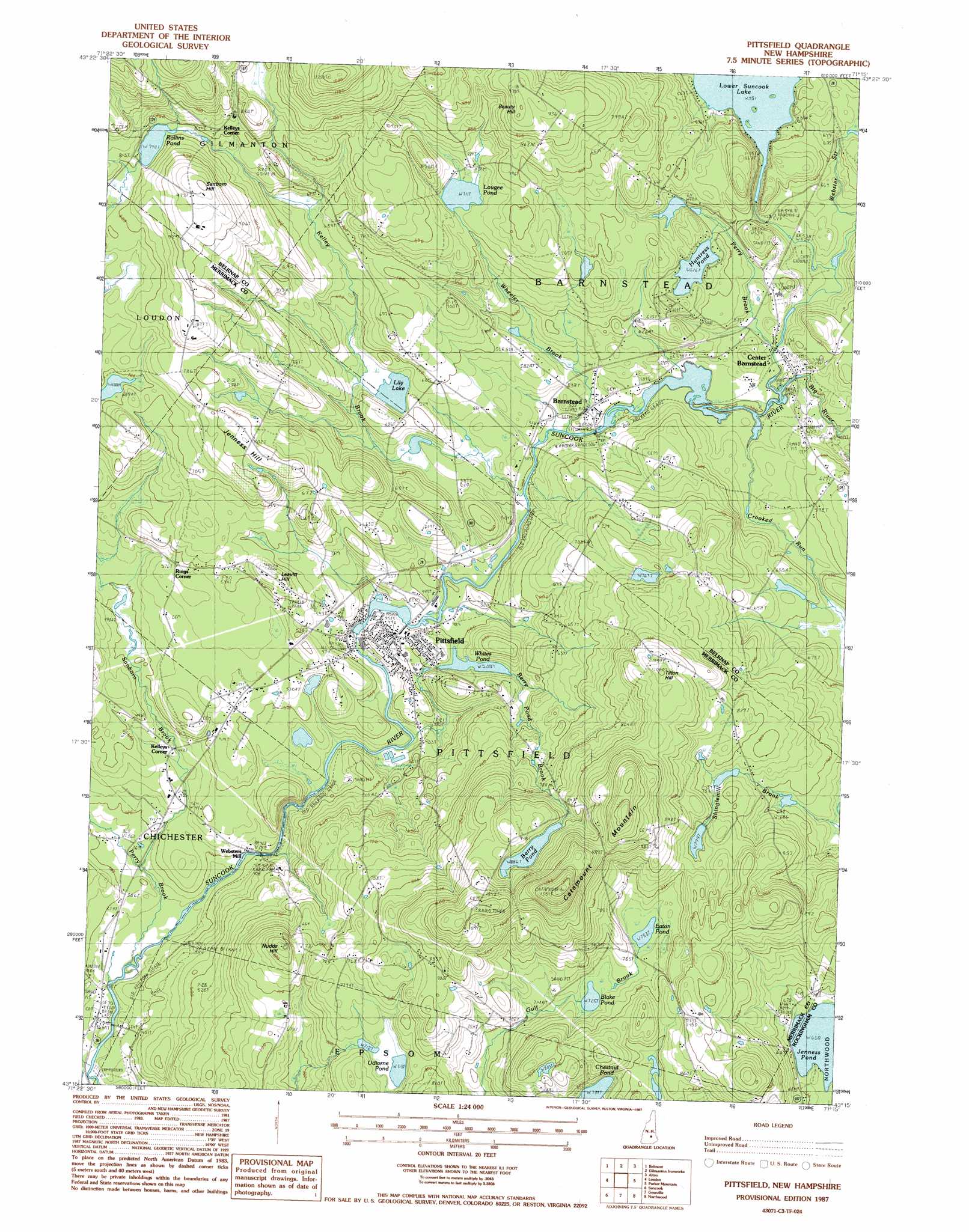
Pittsfield Topo Map New Hampshire
To zoom in, hover over the map of Pittsfield
USGS Topo Quad 43071c3 - 1:24,000 scale
| Topo Map Name: | Pittsfield |
| USGS Topo Quad ID: | 43071c3 |
| Print Size: | ca. 21 1/4" wide x 27" high |
| Southeast Coordinates: | 43.25° N latitude / 71.25° W longitude |
| Map Center Coordinates: | 43.3125° N latitude / 71.3125° W longitude |
| U.S. State: | NH |
| Filename: | o43071c3.jpg |
| Download Map JPG Image: | Pittsfield topo map 1:24,000 scale |
| Map Type: | Topographic |
| Topo Series: | 7.5´ |
| Map Scale: | 1:24,000 |
| Source of Map Images: | United States Geological Survey (USGS) |
| Alternate Map Versions: |
Pittsfield NH 1987, updated 1987 Download PDF Buy paper map Pittsfield NH 2012 Download PDF Buy paper map Pittsfield NH 2015 Download PDF Buy paper map |
1:24,000 Topo Quads surrounding Pittsfield
Winnisquam Lake |
Laconia |
West Alton |
Wolfeboro |
Sanbornville |
Northfield |
Belmont |
Gilmanton Ironworks |
Alton |
Farmington |
Penacook |
Loudon |
Pittsfield |
Parker Mountain |
Baxter Lake |
Concord |
Suncook |
Gossville |
Northwood |
Barrington |
Goffstown |
Manchester North |
Candia |
Mount Pawtuckaway |
Epping |
> Back to 43071a1 at 1:100,000 scale
> Back to 43070a1 at 1:250,000 scale
> Back to U.S. Topo Maps home
Pittsfield topo map: Gazetteer
Pittsfield: Dams
Barnstead Parade Dam elevation 152m 498′Berry Pond Dam elevation 273m 895′
Pittsfield Mill Dam elevation 145m 475′
Suncook Lake Dam elevation 204m 669′
Whites Pond Outlet Dam elevation 168m 551′
Pittsfield: Lakes
Berry Pond elevation 273m 895′Blake Pond elevation 224m 734′
Chestnut Pond elevation 224m 734′
Eaton Pond elevation 230m 754′
Huntress Pond elevation 188m 616′
Jenness Pond elevation 200m 656′
Lily Lake elevation 169m 554′
Lougee Pond elevation 218m 715′
Lower Suncook Lake elevation 168m 551′
Odiorne Pond elevation 218m 715′
Rollins Pond elevation 241m 790′
Pittsfield: Parks
Pittsfield Center Historic District elevation 161m 528′Pittsfield: Populated Places
Barnstead elevation 152m 498′Center Barnstead elevation 157m 515′
Kelleys Corner elevation 134m 439′
Kelleys Corner elevation 259m 849′
North Chichester elevation 110m 360′
Pittsfield elevation 151m 495′
Rings Corner elevation 176m 577′
Websters Mill elevation 123m 403′
Pittsfield: Post Offices
Barnstead Post Office elevation 152m 498′Center Barnstead Post Office elevation 156m 511′
Pittsfield Post Office elevation 162m 531′
Pittsfield: Reservoirs
Berry Pond elevation 273m 895′Suncook Lake elevation 204m 669′
Suncook River Reservoir elevation 152m 498′
Whites Pond elevation 168m 551′
Pittsfield: Streams
Berry Pond Brook elevation 134m 439′Big River elevation 152m 498′
Crooked Run elevation 152m 498′
Kelley Brook elevation 151m 495′
Perry Brook elevation 104m 341′
Perry Brook elevation 155m 508′
Sanborn Brook elevation 110m 360′
Sanders Brook elevation 106m 347′
Webster Stream elevation 157m 515′
Wheeler Brook elevation 151m 495′
Pittsfield: Summits
Beauty Hill elevation 305m 1000′Catamount Mountain elevation 405m 1328′
Jenness Hill elevation 250m 820′
Leavitt Hill elevation 210m 688′
Nudds Hill elevation 252m 826′
Sanborn Hill elevation 306m 1003′
Tilton Hill elevation 304m 997′
Pittsfield digital topo map on disk
Buy this Pittsfield topo map showing relief, roads, GPS coordinates and other geographical features, as a high-resolution digital map file on DVD:
Maine, New Hampshire, Rhode Island & Eastern Massachusetts
Buy digital topo maps: Maine, New Hampshire, Rhode Island & Eastern Massachusetts