Loudon Topo Map New Hampshire
To zoom in, hover over the map of Loudon
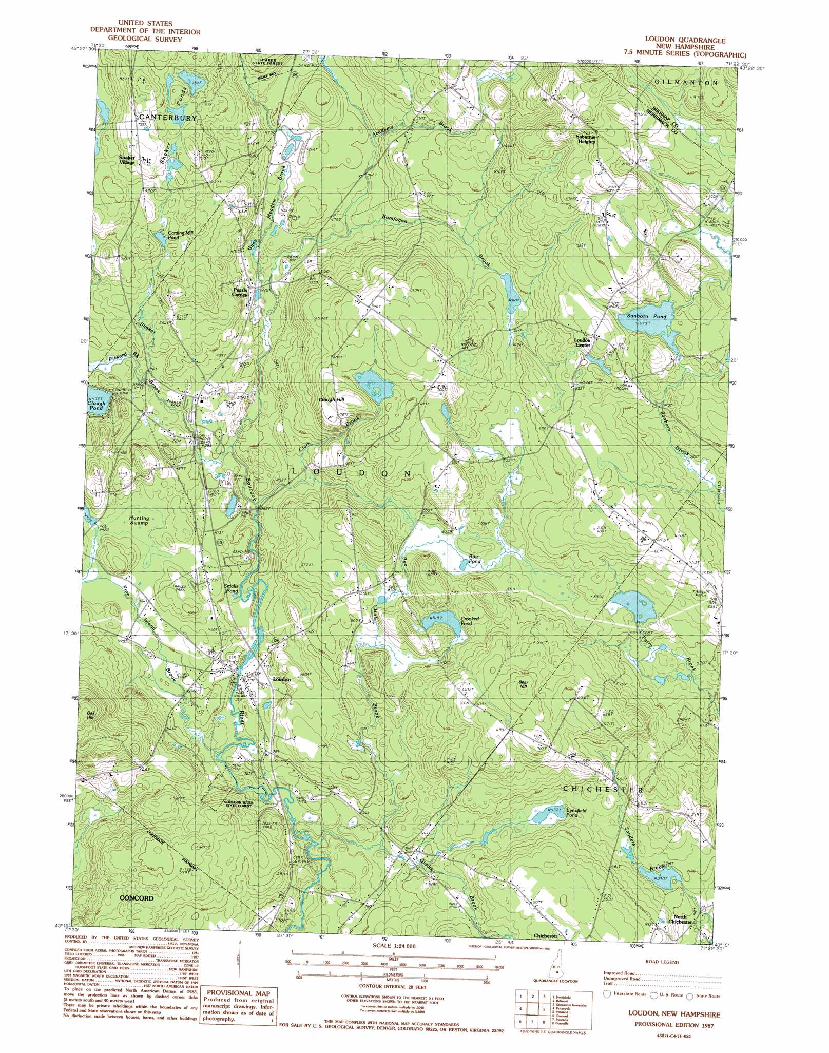
USGS Topo Quad 43071c4 - 1:24,000 scale
| Topo Map Name: | Loudon |
| USGS Topo Quad ID: | 43071c4 |
| Print Size: | ca. 21 1/4" wide x 27" high |
| Southeast Coordinates: | 43.25° N latitude / 71.375° W longitude |
| Map Center Coordinates: | 43.3125° N latitude / 71.4375° W longitude |
| U.S. State: | NH |
| Filename: | o43071c4.jpg |
| Download Map JPG Image: | Loudon topo map 1:24,000 scale |
| Map Type: | Topographic |
| Topo Series: | 7.5´ |
| Map Scale: | 1:24,000 |
| Source of Map Images: | United States Geological Survey (USGS) |
| Alternate Map Versions: |
Loudon NH 1987, updated 1987 Download PDF Buy paper map Loudon NH 1987, updated 1987 Download PDF Buy paper map Loudon NH 2012 Download PDF Buy paper map Loudon NH 2015 Download PDF Buy paper map |
1:24,000 Topo Quads surrounding Loudon
Bristol |
Winnisquam Lake |
Laconia |
West Alton |
Wolfeboro |
Franklin |
Northfield |
Belmont |
Gilmanton Ironworks |
Alton |
Webster |
Penacook |
Loudon |
Pittsfield |
Parker Mountain |
Hopkinton |
Concord |
Suncook |
Gossville |
Northwood |
Weare |
Goffstown |
Manchester North |
Candia |
Mount Pawtuckaway |
> Back to 43071a1 at 1:100,000 scale
> Back to 43070a1 at 1:250,000 scale
> Back to U.S. Topo Maps home
Loudon topo map: Gazetteer
Loudon: Airports
Cooper Farm Landing Strip elevation 148m 485′Crowley Heliport elevation 144m 472′
Speedway Heliport elevation 145m 475′
Loudon: Dams
Center Dam elevation 227m 744′East Dam elevation 221m 725′
East Turning Pond Dam elevation 210m 688′
Long Pond Dike elevation 239m 784′
Sanborn Pond Outlet Dam elevation 203m 666′
West Turning Pond Dam elevation 209m 685′
Loudon: Forests
Soucook River State Forest elevation 122m 400′Loudon: Lakes
Bog Pond elevation 163m 534′Carding Mill Pond elevation 181m 593′
Clough Pond elevation 144m 472′
Crooked Pond elevation 157m 515′
Lynxfield Pond elevation 132m 433′
Sanborn Pond elevation 206m 675′
Shaker Ponds elevation 229m 751′
Smalls Pond elevation 114m 374′
Loudon: Populated Places
Loudon elevation 116m 380′Loudon Center elevation 225m 738′
Pearls Corner elevation 140m 459′
Sabattus Heights elevation 282m 925′
Shaker Village elevation 229m 751′
Loudon: Reservoirs
Center Pond elevation 227m 744′East Turning Pond elevation 210m 688′
Long Pond elevation 239m 784′
Runaway Pond elevation 221m 725′
West Turning Pond elevation 209m 685′
Loudon: Streams
Academy Brook elevation 135m 442′Bee Hole Brook elevation 105m 344′
Bumfagon Brook elevation 122m 400′
Clark Brook elevation 115m 377′
Giddis Brook elevation 101m 331′
Gues Meadow Brook elevation 123m 403′
Pickard Brook elevation 144m 472′
Pine Island Brook elevation 108m 354′
Shaker Branch elevation 122m 400′
Loudon: Summits
Bear Hill elevation 226m 741′Clough Hill elevation 241m 790′
Loudon: Swamps
Hunting Swamp elevation 132m 433′Loudon digital topo map on disk
Buy this Loudon topo map showing relief, roads, GPS coordinates and other geographical features, as a high-resolution digital map file on DVD:
Maine, New Hampshire, Rhode Island & Eastern Massachusetts
Buy digital topo maps: Maine, New Hampshire, Rhode Island & Eastern Massachusetts