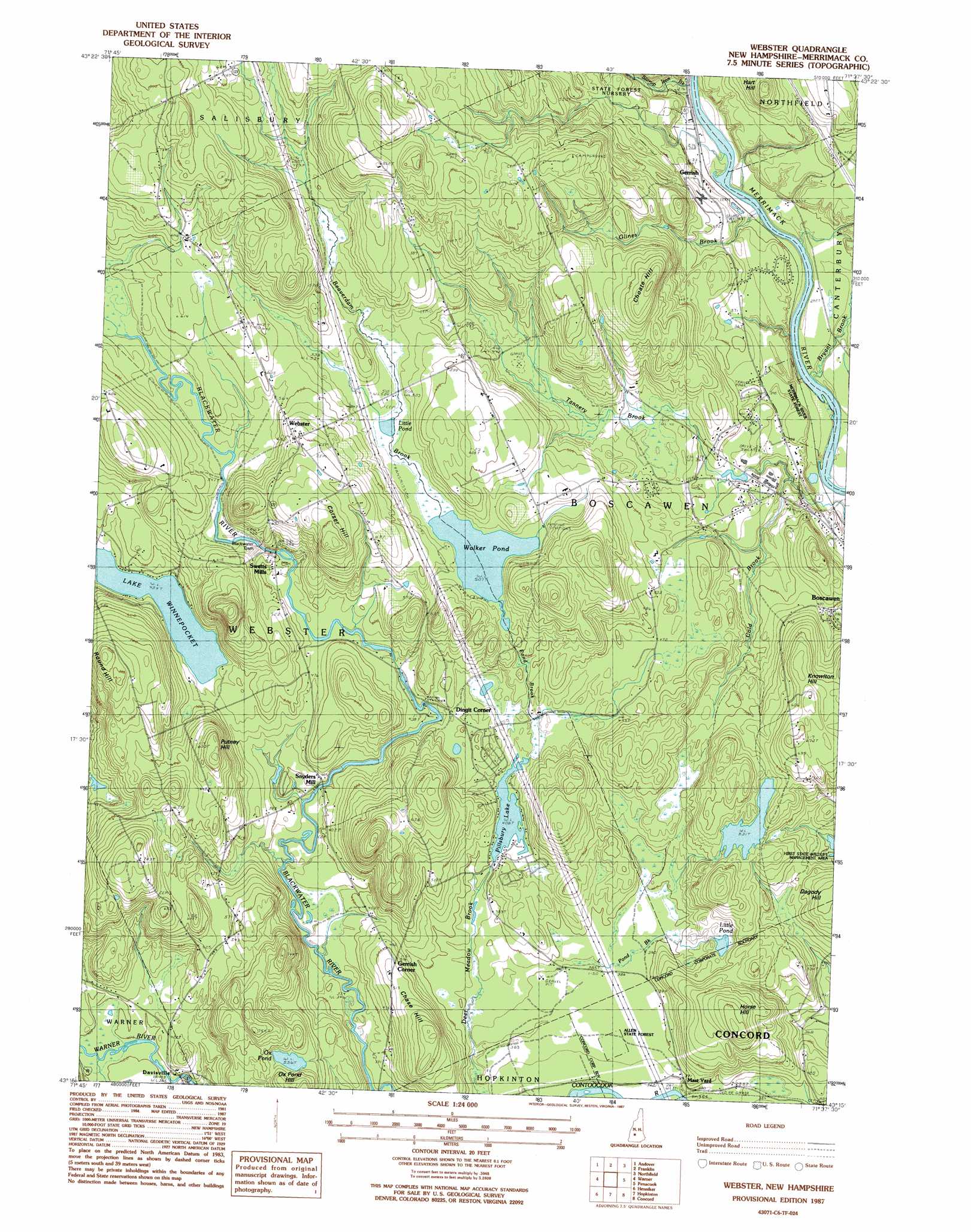
Webster Topo Map New Hampshire
To zoom in, hover over the map of Webster
USGS Topo Quad 43071c6 - 1:24,000 scale
| Topo Map Name: | Webster |
| USGS Topo Quad ID: | 43071c6 |
| Print Size: | ca. 21 1/4" wide x 27" high |
| Southeast Coordinates: | 43.25° N latitude / 71.625° W longitude |
| Map Center Coordinates: | 43.3125° N latitude / 71.6875° W longitude |
| U.S. State: | NH |
| Filename: | o43071c6.jpg |
| Download Map JPG Image: | Webster topo map 1:24,000 scale |
| Map Type: | Topographic |
| Topo Series: | 7.5´ |
| Map Scale: | 1:24,000 |
| Source of Map Images: | United States Geological Survey (USGS) |
| Alternate Map Versions: |
Webster NH 1987, updated 1987 Download PDF Buy paper map Webster NH 1987, updated 1987 Download PDF Buy paper map Webster NH 2000, updated 2001 Download PDF Buy paper map Webster NH 2012 Download PDF Buy paper map Webster NH 2015 Download PDF Buy paper map |
1:24,000 Topo Quads surrounding Webster
Grafton |
Danbury |
Bristol |
Winnisquam Lake |
Laconia |
New London |
Andover |
Franklin |
Northfield |
Belmont |
Bradford |
Warner |
Webster |
Penacook |
Loudon |
Hillsboro Upper Village |
Henniker |
Hopkinton |
Concord |
Suncook |
Hillsboro |
Deering |
Weare |
Goffstown |
Manchester North |
> Back to 43071a1 at 1:100,000 scale
> Back to 43070a1 at 1:250,000 scale
> Back to U.S. Topo Maps home
Webster topo map: Gazetteer
Webster: Dams
Blackwater Dam elevation 166m 544′Flaghole Pond Dam elevation 153m 501′
Pillsbury Lake Dam elevation 124m 406′
Webster: Forests
Allen State Forest elevation 116m 380′Merrimack River State Forest elevation 104m 341′
Webster: Lakes
Lake Winnepocket elevation 138m 452′Little Pond elevation 147m 482′
Little Pond elevation 157m 515′
Ox Pond elevation 168m 551′
Walker Pond elevation 154m 505′
Webster: Parks
Hirst State Wildlife Management Area elevation 134m 439′Jamie Welch Memorial Field elevation 104m 341′
Webster: Populated Places
Davisville elevation 131m 429′Dingit Corner elevation 140m 459′
Gerrish elevation 107m 351′
Gerrish Corner elevation 159m 521′
Snyders Hill elevation 124m 406′
Swetts Mills elevation 163m 534′
Webster elevation 197m 646′
Webster: Reservoirs
Flaghole Pond elevation 153m 501′Pillsbury Lake elevation 124m 406′
Webster: Streams
Beaverdam Brook elevation 155m 508′Bryant Brook elevation 78m 255′
Cold Brook elevation 93m 305′
Glines Brook elevation 79m 259′
Little Pond Brook elevation 109m 357′
Pond Brook elevation 128m 419′
Stirrup Iron Brook elevation 84m 275′
Webster: Summits
Chase Hill elevation 193m 633′Choate Hill elevation 238m 780′
Corser Hill elevation 253m 830′
Hart Hill elevation 186m 610′
Horse Hill elevation 217m 711′
Knowlton Hill elevation 212m 695′
Puthey Hill elevation 223m 731′
Round Hill elevation 247m 810′
Webster digital topo map on disk
Buy this Webster topo map showing relief, roads, GPS coordinates and other geographical features, as a high-resolution digital map file on DVD:
Maine, New Hampshire, Rhode Island & Eastern Massachusetts
Buy digital topo maps: Maine, New Hampshire, Rhode Island & Eastern Massachusetts