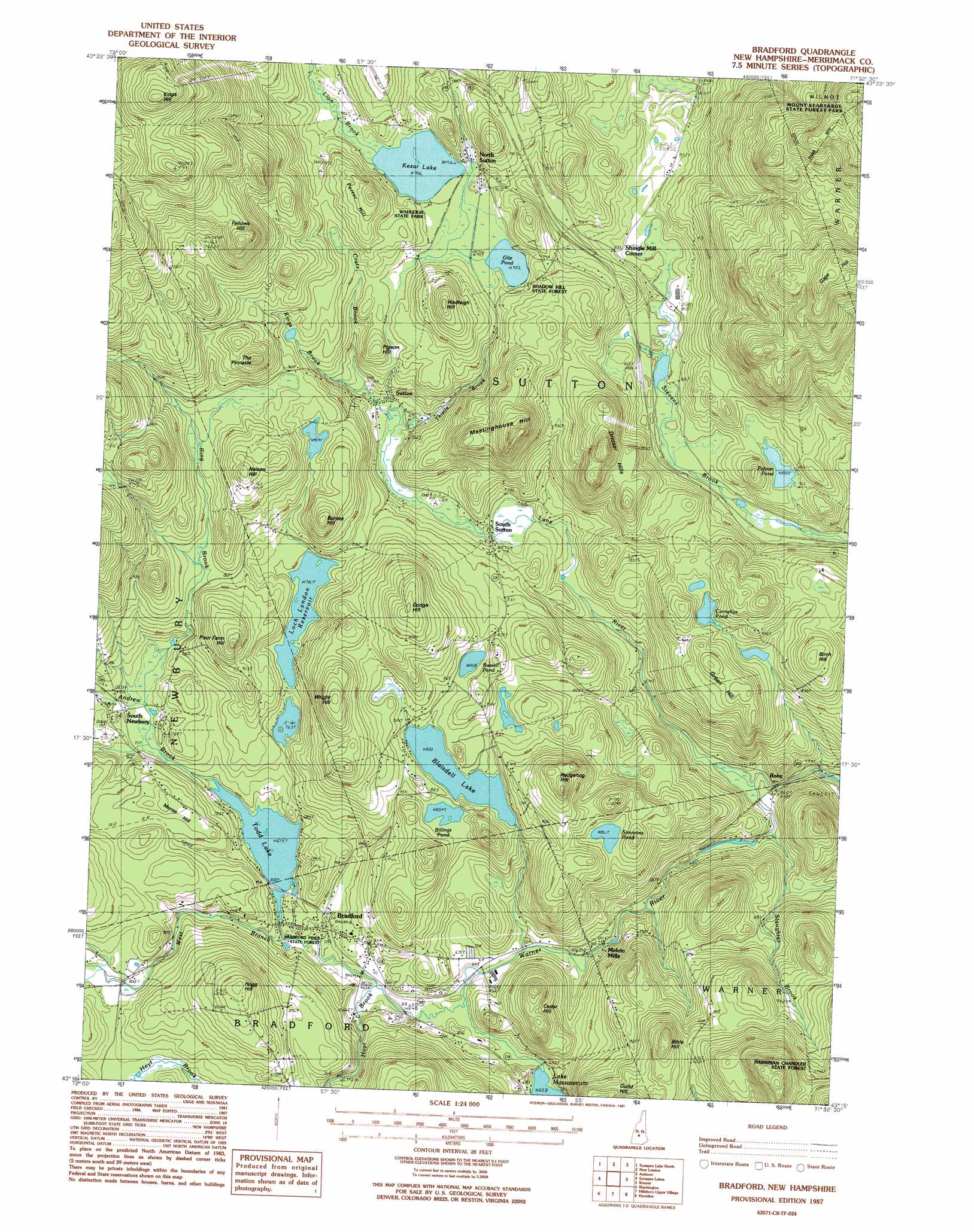
Bradford Topo Map New Hampshire
To zoom in, hover over the map of Bradford
USGS Topo Quad 43071c8 - 1:24,000 scale
| Topo Map Name: | Bradford |
| USGS Topo Quad ID: | 43071c8 |
| Print Size: | ca. 21 1/4" wide x 27" high |
| Southeast Coordinates: | 43.25° N latitude / 71.875° W longitude |
| Map Center Coordinates: | 43.3125° N latitude / 71.9375° W longitude |
| U.S. State: | NH |
| Filename: | o43071c8.jpg |
| Download Map JPG Image: | Bradford topo map 1:24,000 scale |
| Map Type: | Topographic |
| Topo Series: | 7.5´ |
| Map Scale: | 1:24,000 |
| Source of Map Images: | United States Geological Survey (USGS) |
| Alternate Map Versions: |
Bradford NH 1987, updated 1987 Download PDF Buy paper map Bradford NH 1998, updated 2001 Download PDF Buy paper map Bradford NH 2012 Download PDF Buy paper map Bradford NH 2015 Download PDF Buy paper map |
1:24,000 Topo Quads surrounding Bradford
Enfield Center |
Grafton |
Danbury |
Bristol |
|
Sunapee Lake North |
New London |
Andover |
Franklin |
|
Sunapee Lakes |
Bradford |
Warner |
Webster |
|
Washington |
Hillsboro Upper Village |
Henniker |
Hopkinton |
|
Stoddard |
Hillsboro |
Deering |
Weare |
> Back to 43071a1 at 1:100,000 scale
> Back to 43070a1 at 1:250,000 scale
> Back to U.S. Topo Maps home
Bradford topo map: Gazetteer
Bradford: Beaches
Wadleigh State Beach elevation 279m 915′Bradford: Bridges
Bemet Bridge elevation 195m 639′Bradford: Crossings
Interchange 10 elevation 280m 918′Bradford: Dams
Blaisdell Lake Dam elevation 261m 856′Loch Lyndon Reservoir Dam elevation 240m 787′
Todd Lake Dam elevation 208m 682′
Warner River Dam elevation 156m 511′
Bradford: Forests
Bradford Pines State Forest elevation 199m 652′Shadow Hill State Forest elevation 296m 971′
Bradford: Lakes
Billings Pond elevation 260m 853′Cornelius Pond elevation 274m 898′
Gile Pond elevation 279m 915′
Kezar Lake elevation 279m 915′
Palmer Pond elevation 255m 836′
Russell Pond elevation 263m 862′
Simmons Pond elevation 265m 869′
Bradford: Parks
Wadleigh State Park elevation 279m 915′Bradford: Populated Places
Bradford elevation 209m 685′Melvin Mills elevation 196m 643′
North Sutton elevation 279m 915′
Roby elevation 148m 485′
Shingle Mill Corner elevation 254m 833′
South Newbury elevation 223m 731′
South Sutton elevation 220m 721′
Sutton elevation 221m 725′
Bradford: Post Offices
Bradford Post Office elevation 198m 649′Bradford: Reservoirs
Blaisdell Lake elevation 261m 856′Loch Lyndon elevation 242m 793′
Loch Lyndon Reservoir elevation 240m 787′
Todd Lake elevation 206m 675′
Warner River Reservoir elevation 156m 511′
Bradford: Streams
Andrew Brook elevation 207m 679′Crate Brook elevation 228m 748′
Hoyt Brook elevation 194m 636′
Kings Brook elevation 220m 721′
Lane River elevation 149m 488′
Lion Brook elevation 279m 915′
Ring Brook elevation 217m 711′
Shaw Brook elevation 263m 862′
Slaughter Brook elevation 152m 498′
Thistle Brook elevation 220m 721′
West Branch Warner River elevation 194m 636′
Bradford: Summits
Bible Hill elevation 384m 1259′Birch Hill elevation 328m 1076′
Burpee Hill elevation 339m 1112′
Cedar Hill elevation 293m 961′
Dodge Hill elevation 355m 1164′
Dresser Hills elevation 381m 1250′
Fellows Hill elevation 476m 1561′
Gage Hill elevation 539m 1768′
Green Hill elevation 310m 1017′
Hedgehog Hill elevation 357m 1171′
Hogg Hill elevation 349m 1145′
Kimball Hill elevation 290m 951′
Kings Hill elevation 583m 1912′
Meetinghouse Hill elevation 403m 1322′
Morse Hill elevation 262m 859′
Nelson Hill elevation 354m 1161′
Pigeon Hill elevation 302m 990′
Poor Farm Hill elevation 320m 1049′
Porter Hill elevation 350m 1148′
The Pinnacle elevation 380m 1246′
Wadleigh Hill elevation 365m 1197′
Wright Hill elevation 357m 1171′
Bradford digital topo map on disk
Buy this Bradford topo map showing relief, roads, GPS coordinates and other geographical features, as a high-resolution digital map file on DVD:
Maine, New Hampshire, Rhode Island & Eastern Massachusetts
Buy digital topo maps: Maine, New Hampshire, Rhode Island & Eastern Massachusetts