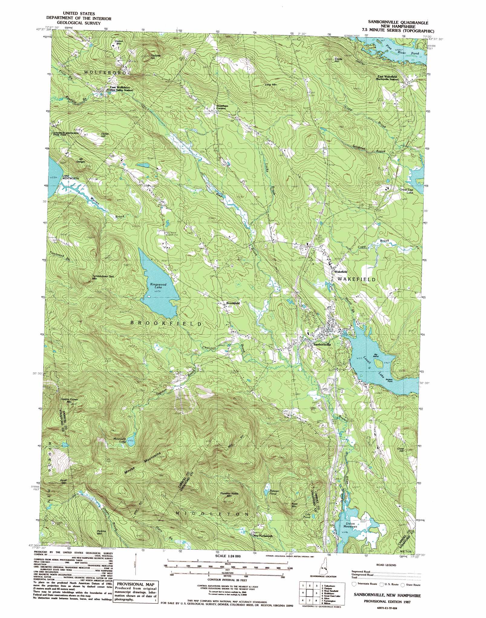
Sanbornville Topo Map New Hampshire
To zoom in, hover over the map of Sanbornville
USGS Topo Quad 43071e1 - 1:24,000 scale
| Topo Map Name: | Sanbornville |
| USGS Topo Quad ID: | 43071e1 |
| Print Size: | ca. 21 1/4" wide x 27" high |
| Southeast Coordinates: | 43.5° N latitude / 71° W longitude |
| Map Center Coordinates: | 43.5625° N latitude / 71.0625° W longitude |
| U.S. State: | NH |
| Filename: | o43071e1.jpg |
| Download Map JPG Image: | Sanbornville topo map 1:24,000 scale |
| Map Type: | Topographic |
| Topo Series: | 7.5´ |
| Map Scale: | 1:24,000 |
| Source of Map Images: | United States Geological Survey (USGS) |
| Alternate Map Versions: |
Sanbornville NH 1987, updated 1987 Download PDF Buy paper map Sanbornville NH 2000, updated 2001 Download PDF Buy paper map Sanbornville NH 2012 Download PDF Buy paper map Sanbornville NH 2015 Download PDF Buy paper map |
1:24,000 Topo Quads surrounding Sanbornville
Tamworth |
Ossipee Lake |
Freedom |
Kezar Falls |
Cornish |
Melvin Village |
Tuftonboro |
Ossipee |
West Newfield |
Limerick |
West Alton |
Wolfeboro |
Sanbornville |
Great East Lake |
Mousam Lake |
Gilmanton Ironworks |
Alton |
Farmington |
Milton |
Sanford |
Pittsfield |
Parker Mountain |
Baxter Lake |
Rochester |
Somersworth |
> Back to 43071e1 at 1:100,000 scale
> Back to 43070a1 at 1:250,000 scale
> Back to U.S. Topo Maps home
Sanbornville topo map: Gazetteer
Sanbornville: Beaches
Lovell Lake Beach elevation 174m 570′Sanbornville: Capes
Nutters Point elevation 182m 597′Sanbornville: Dams
Kingswood Lake Dam elevation 199m 652′Lovell Lake Dam elevation 171m 561′
Sanbornville: Islands
Big Island elevation 177m 580′Sanbornville: Lakes
Bowser Pond elevation 199m 652′Lily Pond elevation 200m 656′
Union Meadows Pond elevation 151m 495′
Sanbornville: Parks
Jones Brook Wildlife Management Area elevation 288m 944′Wakefield Village Historic District elevation 209m 685′
Sanbornville: Populated Places
Brookfield elevation 184m 603′East Wakefield elevation 209m 685′
East Wolfeboro elevation 201m 659′
New Portsmouth elevation 187m 613′
Sanbornville elevation 176m 577′
Wakefield elevation 203m 666′
Sanbornville: Post Offices
Sanbornville Post Office elevation 164m 538′Sanbornville: Reservoirs
Kingswood Lake elevation 208m 682′Lovell Lake elevation 171m 561′
Mountain Lake elevation 285m 935′
Union Meadows elevation 151m 495′
Sanbornville: Ridges
Long Mountain elevation 333m 1092′Sanbornville: Streams
Churchill Brook elevation 158m 518′Hanson Brook elevation 171m 561′
Horse Brook elevation 175m 574′
Locke Brook elevation 181m 593′
Pike Brook elevation 158m 518′
Scribner Brook elevation 175m 574′
Warren Brook elevation 163m 534′
Sanbornville: Summits
Clows Hill elevation 295m 967′Cooks Hill elevation 300m 984′
Copp Hill elevation 274m 898′
Copple Crown Mountain elevation 535m 1755′
Cotton Mountain elevation 386m 1266′
Moose Mountains elevation 527m 1729′
Mount Delight elevation 267m 875′
Perkins Mountain elevation 353m 1158′
Phoebes Nable Mountain elevation 353m 1158′
Piper Mountain elevation 294m 964′
Rand Mountain elevation 396m 1299′
Tibbetts Hill elevation 338m 1108′
Tumbledown Dick Mountain elevation 345m 1131′
Sanbornville digital topo map on disk
Buy this Sanbornville topo map showing relief, roads, GPS coordinates and other geographical features, as a high-resolution digital map file on DVD:
Maine, New Hampshire, Rhode Island & Eastern Massachusetts
Buy digital topo maps: Maine, New Hampshire, Rhode Island & Eastern Massachusetts