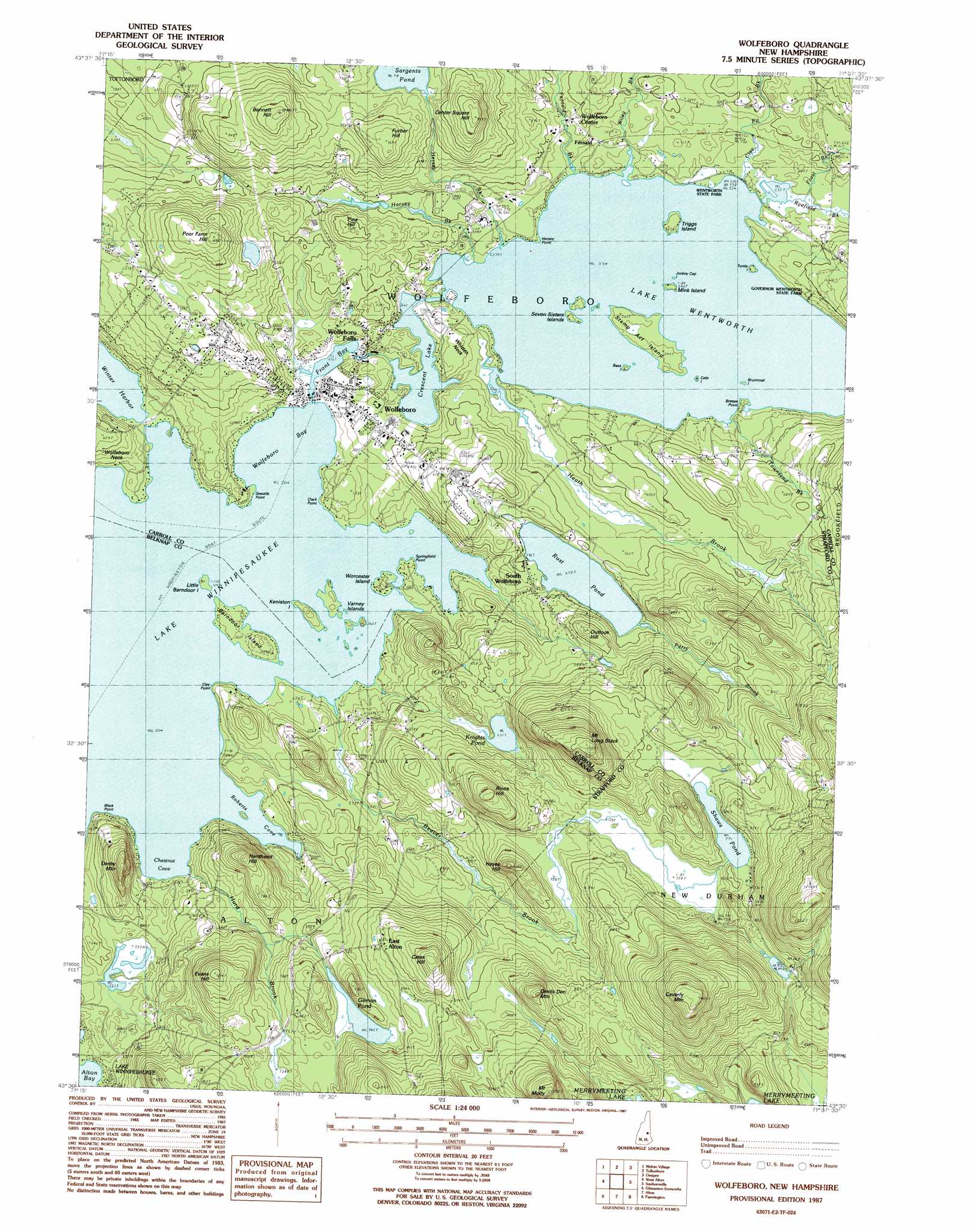
Wolfeboro Topo Map New Hampshire
To zoom in, hover over the map of Wolfeboro
USGS Topo Quad 43071e2 - 1:24,000 scale
| Topo Map Name: | Wolfeboro |
| USGS Topo Quad ID: | 43071e2 |
| Print Size: | ca. 21 1/4" wide x 27" high |
| Southeast Coordinates: | 43.5° N latitude / 71.125° W longitude |
| Map Center Coordinates: | 43.5625° N latitude / 71.1875° W longitude |
| U.S. State: | NH |
| Filename: | o43071e2.jpg |
| Download Map JPG Image: | Wolfeboro topo map 1:24,000 scale |
| Map Type: | Topographic |
| Topo Series: | 7.5´ |
| Map Scale: | 1:24,000 |
| Source of Map Images: | United States Geological Survey (USGS) |
| Alternate Map Versions: |
Wolfeboro NH 1987, updated 1987 Download PDF Buy paper map Wolfeboro NH 2012 Download PDF Buy paper map Wolfeboro NH 2015 Download PDF Buy paper map |
1:24,000 Topo Quads surrounding Wolfeboro
Center Sandwich |
Tamworth |
Ossipee Lake |
Freedom |
Kezar Falls |
Center Harbor |
Melvin Village |
Tuftonboro |
Ossipee |
West Newfield |
Laconia |
West Alton |
Wolfeboro |
Sanbornville |
Great East Lake |
Belmont |
Gilmanton Ironworks |
Alton |
Farmington |
Milton |
Loudon |
Pittsfield |
Parker Mountain |
Baxter Lake |
Rochester |
> Back to 43071e1 at 1:100,000 scale
> Back to 43070a1 at 1:250,000 scale
> Back to U.S. Topo Maps home
Wolfeboro topo map: Gazetteer
Wolfeboro: Airports
Springfield Point Heliport elevation 164m 538′Wolfeboro: Bars
Goose Rock elevation 163m 534′Wolfeboro: Bays
Chestnut Cove elevation 153m 501′Delings Cove elevation 153m 501′
Fernalds Basin elevation 163m 534′
Fishermans Cove elevation 153m 501′
Front Bay elevation 155m 508′
Goodwins Basin elevation 163m 534′
Jockey Cove elevation 153m 501′
Puffs Cove elevation 153m 501′
Roberts Cove elevation 153m 501′
South Wolfeboro Bay elevation 153m 501′
Tips Cove elevation 153m 501′
Wolfeboro Bay elevation 153m 501′
Wolfeboro: Beaches
Allen Albee Beach elevation 163m 534′Brewster Beach elevation 153m 501′
Clows Beach elevation 163m 534′
Wolfeboro Town Beach elevation 153m 501′
Wolfeboro: Capes
Black Point elevation 156m 511′Breeze Point elevation 163m 534′
Clark Point elevation 153m 501′
Clay Point elevation 155m 508′
Furber Point elevation 157m 515′
Hersey Point elevation 165m 541′
Moose Point elevation 163m 534′
Pipers Point elevation 154m 505′
Point of Pines elevation 163m 534′
Sewalls Point elevation 158m 518′
Springfield Point elevation 153m 501′
Sunset Point elevation 163m 534′
Whitten Neck elevation 175m 574′
Wolfeboro: Dams
Crescent Lake Dam elevation 167m 547′Rust Pond Dam elevation 177m 580′
Spray Irrigation Storage Reservoir Dam elevation 207m 679′
Wolfeboro: Islands
Barndoor Island elevation 157m 515′Bass Island elevation 163m 534′
Blueberry Island elevation 154m 505′
Brummet Island elevation 163m 534′
Cate Island elevation 163m 534′
Chip Island elevation 153m 501′
Church Island elevation 154m 505′
Flo Island elevation 163m 534′
Gate Island elevation 153m 501′
Harbor Island elevation 153m 501′
Harmony Island elevation 156m 511′
JIB Island elevation 157m 515′
Jockey Cap Island elevation 163m 534′
Joe Island elevation 163m 534′
Keel Island elevation 153m 501′
Keniston Island elevation 159m 521′
Ledge Island elevation 153m 501′
Little Barndoor Island elevation 155m 508′
Little Kenniston Island elevation 153m 501′
Long Pine Island elevation 153m 501′
Loon Island elevation 163m 534′
Melody Island elevation 157m 515′
Min Island elevation 163m 534′
Mink Island elevation 163m 534′
Mud Island elevation 154m 505′
Overnight Island elevation 153m 501′
Poplar Island elevation 165m 541′
Scavenger Island elevation 153m 501′
Seven Sisters Islands elevation 163m 534′
Shelter Island elevation 153m 501′
Spider Island elevation 153m 501′
Stamp Act Island elevation 164m 538′
Triggs Island elevation 165m 541′
Turtle Island elevation 163m 534′
Upper Shore Island elevation 153m 501′
Varney Islands elevation 153m 501′
Wal Island elevation 163m 534′
West Jockey Cap Island elevation 163m 534′
Winch Island elevation 153m 501′
Worcester Island elevation 159m 521′
Wolfeboro: Lakes
Crescent Lake elevation 162m 531′Gilman Pond elevation 236m 774′
Knights Pond elevation 192m 629′
Lake Wentworth elevation 163m 534′
Sargents Pond elevation 218m 715′
Shaws Pond elevation 235m 770′
Wolfeboro: Parks
Cate Park elevation 162m 531′Foss Field elevation 156m 511′
McKinney Park elevation 153m 501′
South Wolfeboro Playground elevation 177m 580′
Wentworth State Park elevation 163m 534′
Wolfeboro: Pillars
Gull Rock elevation 163m 534′Wolfeboro: Populated Places
East Alton elevation 263m 862′Fernald elevation 165m 541′
Goose Corner elevation 203m 666′
South Wolfeboro elevation 171m 561′
Wolfeboro elevation 170m 557′
Wolfeboro Center elevation 171m 561′
Wolfeboro Falls elevation 158m 518′
Wolfeboro: Post Offices
Wolfeboro Falls Post Office (historical) elevation 159m 521′Wolfeboro Post Office elevation 165m 541′
Wolfeboro: Reservoirs
Rust Pond elevation 177m 580′Trapper Pond elevation 199m 652′
Wolfeboro: Streams
Baker Brook elevation 176m 577′Beaver Brook elevation 154m 505′
Clay Pit Brook elevation 163m 534′
Fernald Brook elevation 163m 534′
Frost Brook elevation 164m 538′
Harvey Brook elevation 163m 534′
Heath Brook elevation 163m 534′
Hersey Brook elevation 164m 538′
Hurd Brook elevation 153m 501′
Morrill Brook elevation 163m 534′
Perry Brook elevation 177m 580′
Ryefield Brook elevation 163m 534′
Townsend Brook elevation 163m 534′
Wiley Brook elevation 163m 534′
Wolfeboro: Summits
Bennett Hill elevation 289m 948′Cates Hill elevation 326m 1069′
Caverly Mountain elevation 410m 1345′
Center Square Hill elevation 288m 944′
Derby Mountain elevation 257m 843′
Devils Den Mountain elevation 319m 1046′
Evans Hill elevation 283m 928′
Furber Hill elevation 263m 862′
Hardhead Hill elevation 255m 836′
Hayes Hill elevation 254m 833′
Mount Long Stack elevation 367m 1204′
Mount Molly elevation 355m 1164′
Outlook Hill elevation 225m 738′
Pine Hill elevation 216m 708′
Poor Farm Hill elevation 266m 872′
Rines Hill elevation 295m 967′
Wolfeboro: Swamps
Ryefield Marsh elevation 164m 538′Wolfeboro digital topo map on disk
Buy this Wolfeboro topo map showing relief, roads, GPS coordinates and other geographical features, as a high-resolution digital map file on DVD:
Maine, New Hampshire, Rhode Island & Eastern Massachusetts
Buy digital topo maps: Maine, New Hampshire, Rhode Island & Eastern Massachusetts