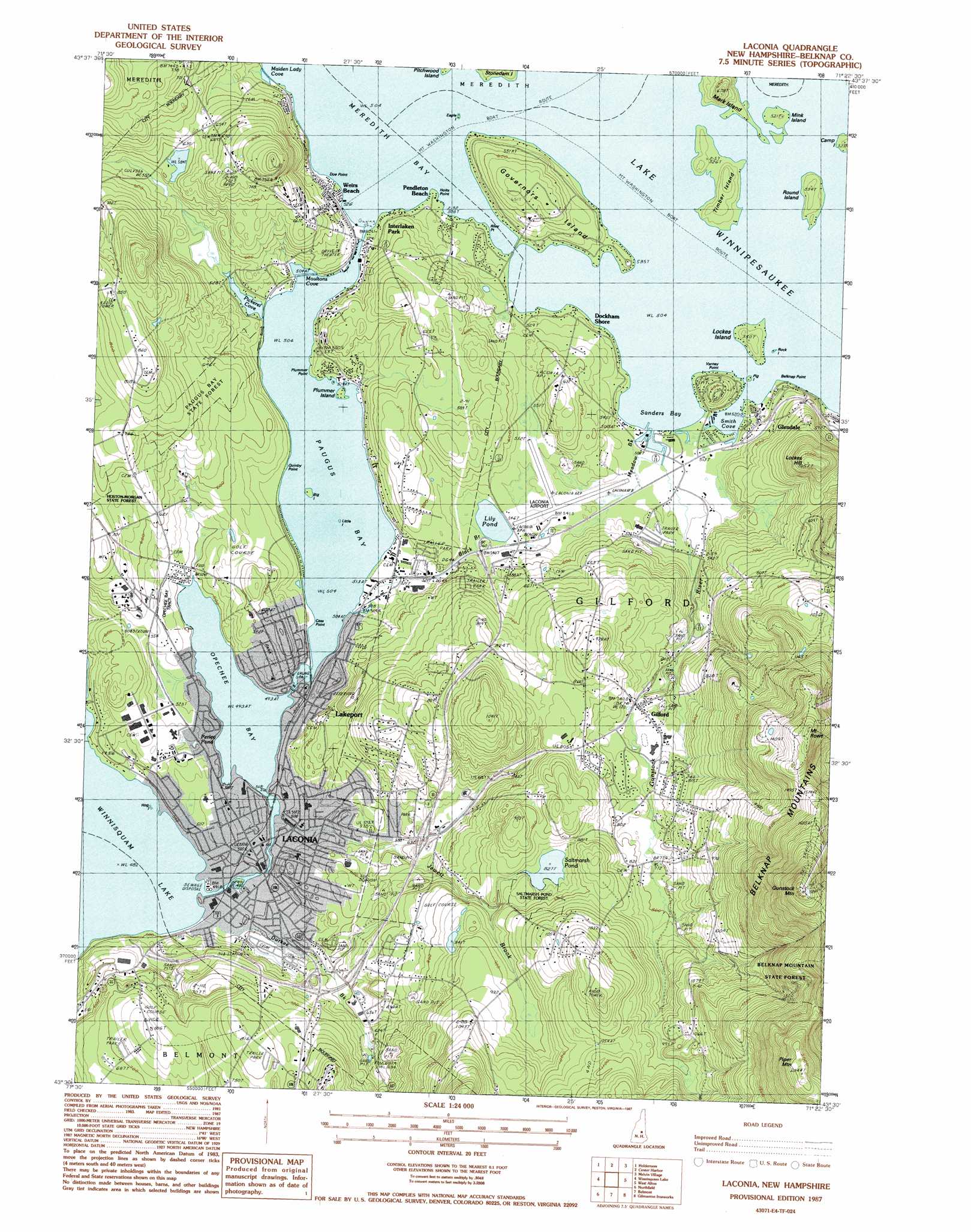
Laconia Topo Map New Hampshire
To zoom in, hover over the map of Laconia
USGS Topo Quad 43071e4 - 1:24,000 scale
| Topo Map Name: | Laconia |
| USGS Topo Quad ID: | 43071e4 |
| Print Size: | ca. 21 1/4" wide x 27" high |
| Southeast Coordinates: | 43.5° N latitude / 71.375° W longitude |
| Map Center Coordinates: | 43.5625° N latitude / 71.4375° W longitude |
| U.S. State: | NH |
| Filename: | o43071e4.jpg |
| Download Map JPG Image: | Laconia topo map 1:24,000 scale |
| Map Type: | Topographic |
| Topo Series: | 7.5´ |
| Map Scale: | 1:24,000 |
| Source of Map Images: | United States Geological Survey (USGS) |
| Alternate Map Versions: |
Laconia NH 1987, updated 1987 Download PDF Buy paper map Laconia NH 1987, updated 1987 Download PDF Buy paper map Laconia NH 2012 Download PDF Buy paper map Laconia NH 2015 Download PDF Buy paper map |
1:24,000 Topo Quads surrounding Laconia
Plymouth |
Squam Mountains |
Center Sandwich |
Tamworth |
Ossipee Lake |
Ashland |
Holderness |
Center Harbor |
Melvin Village |
Tuftonboro |
Bristol |
Winnisquam Lake |
Laconia |
West Alton |
Wolfeboro |
Franklin |
Northfield |
Belmont |
Gilmanton Ironworks |
Alton |
Webster |
Penacook |
Loudon |
Pittsfield |
Parker Mountain |
> Back to 43071e1 at 1:100,000 scale
> Back to 43070a1 at 1:250,000 scale
> Back to U.S. Topo Maps home
Laconia topo map: Gazetteer
Laconia: Airports
Laconia Municipal Airport elevation 160m 524′Laconia: Bars
Nipple Rock elevation 153m 501′The Witches elevation 153m 501′
Laconia: Basins
Gilford Bowl elevation 156m 511′Laconia: Bays
Maiden Lady Cove elevation 154m 505′Moultons Cove elevation 153m 501′
Opechee Bay elevation 150m 492′
Paugus Bay elevation 153m 501′
Pickerel Cove elevation 153m 501′
Sanders Bay elevation 153m 501′
Smith Cove elevation 153m 501′
Laconia: Beaches
Endicott Park Beach elevation 155m 508′Gilford Beach elevation 153m 501′
Laconia: Capes
Belknap Point elevation 156m 511′Cass Point elevation 157m 515′
Dixon Point elevation 148m 485′
Doe Point elevation 157m 515′
Hoits Point elevation 154m 505′
Plummer Point elevation 159m 521′
Quinby Point elevation 155m 508′
Riley Point elevation 158m 518′
Varney Point elevation 186m 610′
Laconia: Channels
Weirs Channel elevation 153m 501′Laconia: Dams
Avery Dam elevation 149m 488′Footes Pond Dam elevation 171m 561′
Lakeport Dam elevation 152m 498′
Laconia: Forests
Opechee Bay Tract elevation 160m 524′Saltmarsh Pond State Forest elevation 262m 859′
Laconia: Islands
Big Island elevation 153m 501′Eagle Island elevation 154m 505′
Governors Island elevation 197m 646′
Hog Island elevation 147m 482′
Little Island elevation 153m 501′
Locks Island elevation 167m 547′
Mark Island elevation 190m 623′
Mink Island elevation 158m 518′
Pig Island elevation 153m 501′
Pitchwood Island elevation 155m 508′
Plummer Island elevation 154m 505′
Rock Island elevation 154m 505′
Round Island elevation 165m 541′
Timber Island elevation 167m 547′
Laconia: Lakes
Lily Pond elevation 163m 534′Perley Pond elevation 164m 538′
Saltmarsh Pond elevation 253m 830′
Laconia: Parks
Bond Park elevation 177m 580′Bond Park elevation 172m 564′
Endicott Rock Park elevation 156m 511′
Leavitt Park elevation 169m 554′
Leavitt Park Playground elevation 170m 557′
Memorial Park elevation 150m 492′
Mill Plaza elevation 149m 488′
Opechee Park elevation 156m 511′
Opechee Park elevation 154m 505′
Wyatt Park elevation 154m 505′
Wyatt Park elevation 153m 501′
Laconia: Populated Places
Dockham Shore elevation 164m 538′Gilford elevation 225m 738′
Glendale elevation 167m 547′
Interlaken Park elevation 157m 515′
Laconia elevation 153m 501′
Lakeport elevation 156m 511′
Mallard Cove elevation 153m 501′
Pendleton Beach elevation 155m 508′
The Ledges elevation 233m 764′
Weirs Beach elevation 163m 534′
Wildwood Village elevation 158m 518′
Laconia: Post Offices
Laconia Post Office elevation 154m 505′Weirs Beach Post Office elevation 165m 541′
Laconia: Reservoirs
Footes Pond elevation 171m 561′Opechee Bay Reservoir elevation 149m 488′
Laconia: Streams
Black Brook elevation 155m 508′Durkee Brook elevation 147m 482′
Gunstock River elevation 153m 501′
Jewett Brook elevation 150m 492′
Meadow Brook elevation 153m 501′
Laconia: Summits
Buckyard Mountain elevation 284m 931′Gunstock Mountain elevation 674m 2211′
Lockes Hill elevation 320m 1049′
Mount Rowe elevation 508m 1666′
Piper Mountain elevation 618m 2027′
Laconia digital topo map on disk
Buy this Laconia topo map showing relief, roads, GPS coordinates and other geographical features, as a high-resolution digital map file on DVD:
Maine, New Hampshire, Rhode Island & Eastern Massachusetts
Buy digital topo maps: Maine, New Hampshire, Rhode Island & Eastern Massachusetts