Winnisquam Lake Topo Map New Hampshire
To zoom in, hover over the map of Winnisquam Lake
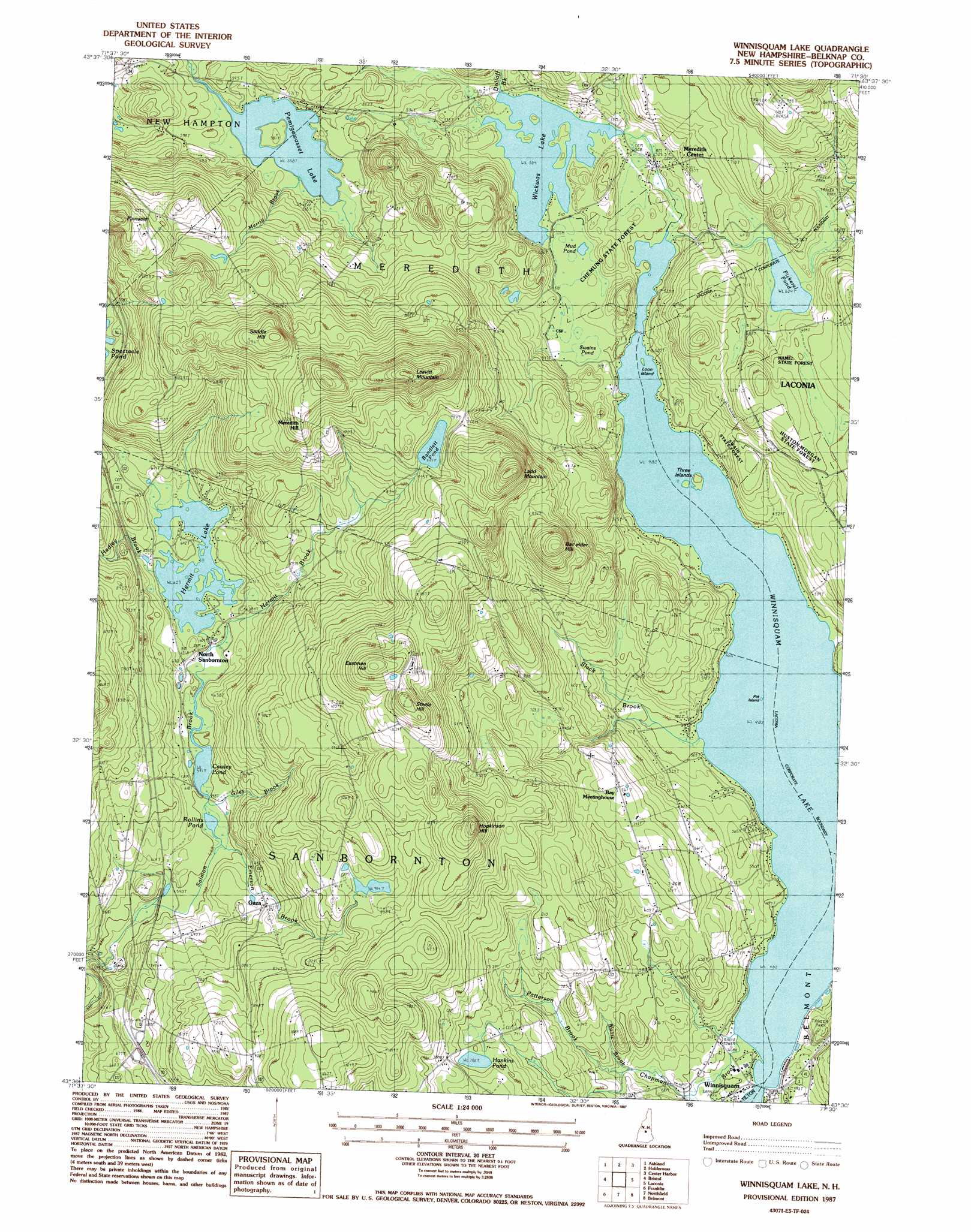
USGS Topo Quad 43071e5 - 1:24,000 scale
| Topo Map Name: | Winnisquam Lake |
| USGS Topo Quad ID: | 43071e5 |
| Print Size: | ca. 21 1/4" wide x 27" high |
| Southeast Coordinates: | 43.5° N latitude / 71.5° W longitude |
| Map Center Coordinates: | 43.5625° N latitude / 71.5625° W longitude |
| U.S. State: | NH |
| Filename: | o43071e5.jpg |
| Download Map JPG Image: | Winnisquam Lake topo map 1:24,000 scale |
| Map Type: | Topographic |
| Topo Series: | 7.5´ |
| Map Scale: | 1:24,000 |
| Source of Map Images: | United States Geological Survey (USGS) |
| Alternate Map Versions: |
Winnisquam Lake NH 1987, updated 1987 Download PDF Buy paper map Winnisquam Lake NH 2012 Download PDF Buy paper map Winnisquam Lake NH 2015 Download PDF Buy paper map |
1:24,000 Topo Quads surrounding Winnisquam Lake
Rumney |
Plymouth |
Squam Mountains |
Center Sandwich |
Tamworth |
Newfound Lake |
Ashland |
Holderness |
Center Harbor |
Melvin Village |
Danbury |
Bristol |
Winnisquam Lake |
Laconia |
West Alton |
Andover |
Franklin |
Northfield |
Belmont |
Gilmanton Ironworks |
Warner |
Webster |
Penacook |
Loudon |
Pittsfield |
> Back to 43071e1 at 1:100,000 scale
> Back to 43070a1 at 1:250,000 scale
> Back to U.S. Topo Maps home
Winnisquam Lake topo map: Gazetteer
Winnisquam Lake: Cliffs
Crocketts Ledge elevation 219m 718′White Mountain Ledge elevation 224m 734′
Winnisquam Lake: Dams
Storage Dam at Weeks Mill elevation 193m 633′Wickwas Lake Dam elevation 159m 521′
Winnisquam Lake: Forests
Chemung State Forest elevation 179m 587′Hamel State Forest elevation 207m 679′
Huston-Morgan State Forest elevation 226m 741′
Swain State Forest elevation 176m 577′
Winnisquam Lake: Islands
Loon Island elevation 147m 482′Pot Island elevation 147m 482′
Three Islands elevation 155m 508′
Winnisquam Lake: Lakes
Arbutus Hill Pond elevation 211m 692′Beaver Meadow Pond elevation 180m 590′
Cawley Pond elevation 182m 597′
Hunkins Pond elevation 240m 787′
Mud Pond elevation 156m 511′
Pemingewasset Lake elevation 172m 564′
Pickerel Pond elevation 190m 623′
Randlett Pond elevation 291m 954′
Rollins Pond elevation 182m 597′
Swamp Pond elevation 154m 505′
Winnisquam Lake: Parks
Eames Recreation and Wildlife Area elevation 228m 748′Hamlin Recreation and Conservation Area elevation 202m 662′
Pinnacle Park elevation 367m 1204′
Winnisquam Lake: Populated Places
Gaza elevation 217m 711′Meredith Center elevation 168m 551′
Meredith Hill elevation 372m 1220′
North Sanbornton elevation 191m 626′
Winnisquam elevation 147m 482′
Winnisquam Lake: Reservoirs
Double Dammed Pond elevation 193m 633′Hermit Lake elevation 193m 633′
Wickwas Lake elevation 159m 521′
Winnisquam Lake: Streams
Black Brook elevation 147m 482′Chapman Brook elevation 147m 482′
Dolloff Brook elevation 155m 508′
Emerson Brook elevation 182m 597′
Giles Brook elevation 183m 600′
Hadley Brook elevation 190m 623′
Hermit Brook elevation 182m 597′
Merrill Brook elevation 172m 564′
Patterson Brook elevation 166m 544′
Wallis Brook elevation 177m 580′
Winnisquam Lake: Summits
Bachelder Hill elevation 358m 1174′Eastman Hill elevation 422m 1384′
Hopkinson Hill elevation 405m 1328′
Ladd Mountain elevation 404m 1325′
Leavitt Mountain elevation 427m 1400′
Leighton Mountain elevation 424m 1391′
Saddle Hill elevation 392m 1286′
Snow Dragon Mountain elevation 368m 1207′
Steele Hill elevation 406m 1332′
Winnisquam Lake digital topo map on disk
Buy this Winnisquam Lake topo map showing relief, roads, GPS coordinates and other geographical features, as a high-resolution digital map file on DVD:
Maine, New Hampshire, Rhode Island & Eastern Massachusetts
Buy digital topo maps: Maine, New Hampshire, Rhode Island & Eastern Massachusetts