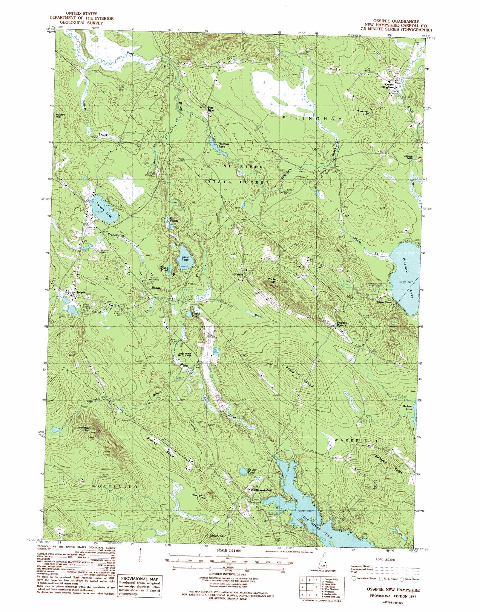
Ossipee Topo Map New Hampshire
To zoom in, hover over the map of Ossipee
USGS Topo Quad 43071f1 - 1:24,000 scale
| Topo Map Name: | Ossipee |
| USGS Topo Quad ID: | 43071f1 |
| Print Size: | ca. 21 1/4" wide x 27" high |
| Southeast Coordinates: | 43.625° N latitude / 71° W longitude |
| Map Center Coordinates: | 43.6875° N latitude / 71.0625° W longitude |
| U.S. State: | NH |
| Filename: | o43071f1.jpg |
| Download Map JPG Image: | Ossipee topo map 1:24,000 scale |
| Map Type: | Topographic |
| Topo Series: | 7.5´ |
| Map Scale: | 1:24,000 |
| Source of Map Images: | United States Geological Survey (USGS) |
| Alternate Map Versions: |
Ossipee NH 1987, updated 1987 Download PDF Buy paper map Ossipee NH 1998, updated 1999 Download PDF Buy paper map Ossipee NH 2012 Download PDF Buy paper map Ossipee NH 2015 Download PDF Buy paper map |
1:24,000 Topo Quads surrounding Ossipee
Mount Chocorua |
Silver Lake |
Conway |
Brownfield |
Hiram |
Tamworth |
Ossipee Lake |
Freedom |
Kezar Falls |
Cornish |
Melvin Village |
Tuftonboro |
Ossipee |
West Newfield |
Limerick |
West Alton |
Wolfeboro |
Sanbornville |
Great East Lake |
Mousam Lake |
Gilmanton Ironworks |
Alton |
Farmington |
Milton |
Sanford |
> Back to 43071e1 at 1:100,000 scale
> Back to 43070a1 at 1:250,000 scale
> Back to U.S. Topo Maps home
Ossipee topo map: Gazetteer
Ossipee: Dams
Arthur H Fox Memorial Dam elevation 181m 593′Huckins Pond Dam elevation 134m 439′
Ossipee: Forests
Pine River State Forest elevation 159m 521′Ossipee: Islands
Overlook Island elevation 178m 583′Ossipee: Lakes
Black Pond elevation 152m 498′Duncan Lake elevation 176m 577′
Lost Ponds elevation 145m 475′
Round Pond elevation 195m 639′
Snake Pond elevation 152m 498′
White Pond elevation 145m 475′
Ossipee: Populated Places
Center Effingham elevation 135m 442′Chases Mill elevation 142m 465′
Granite elevation 213m 698′
Grape Corner elevation 228m 748′
North Wakefield elevation 182m 597′
Ossipee elevation 202m 662′
Pine River elevation 149m 488′
Ossipee: Post Offices
Ossipee Post Office elevation 206m 675′Ossipee: Reservoirs
Hutchins Pond elevation 134m 439′Pine River Pond elevation 178m 583′
Ossipee: Ridges
Ballard Ridge elevation 294m 964′Browns Ridge elevation 251m 823′
Foggs Ridge elevation 290m 951′
Ossipee: Streams
Frenchman Brook elevation 146m 479′Hobbs Brook elevation 148m 485′
Peavey Brook elevation 125m 410′
Pike Brook elevation 144m 472′
Poland Brook elevation 146m 479′
Red Pine Brook elevation 131m 429′
Wilkinson Brook elevation 128m 419′
Youngs Brook elevation 152m 498′
Ossipee: Summits
Milliken Hill elevation 200m 656′Pocket Mountain elevation 360m 1181′
Porcupine Hill elevation 242m 793′
Pray Hill elevation 303m 994′
Rumney Hill elevation 209m 685′
Whiteface Mountain elevation 400m 1312′
Ossipee digital topo map on disk
Buy this Ossipee topo map showing relief, roads, GPS coordinates and other geographical features, as a high-resolution digital map file on DVD:
Maine, New Hampshire, Rhode Island & Eastern Massachusetts
Buy digital topo maps: Maine, New Hampshire, Rhode Island & Eastern Massachusetts