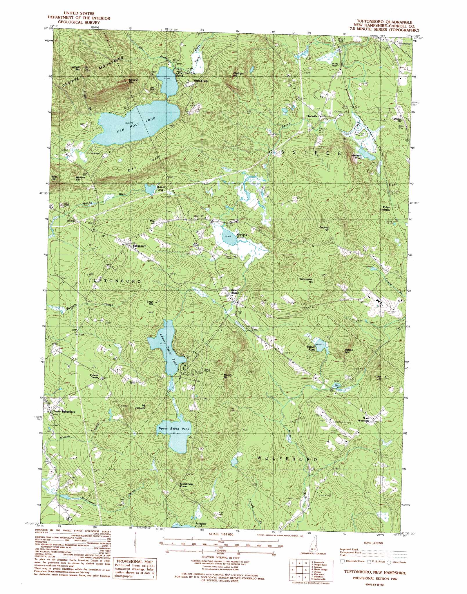
Tuftonboro Topo Map New Hampshire
To zoom in, hover over the map of Tuftonboro
USGS Topo Quad 43071f2 - 1:24,000 scale
| Topo Map Name: | Tuftonboro |
| USGS Topo Quad ID: | 43071f2 |
| Print Size: | ca. 21 1/4" wide x 27" high |
| Southeast Coordinates: | 43.625° N latitude / 71.125° W longitude |
| Map Center Coordinates: | 43.6875° N latitude / 71.1875° W longitude |
| U.S. State: | NH |
| Filename: | o43071f2.jpg |
| Download Map JPG Image: | Tuftonboro topo map 1:24,000 scale |
| Map Type: | Topographic |
| Topo Series: | 7.5´ |
| Map Scale: | 1:24,000 |
| Source of Map Images: | United States Geological Survey (USGS) |
| Alternate Map Versions: |
Tuftonboro NH 1987, updated 1987 Download PDF Buy paper map Tuftonboro NH 2000, updated 2001 Download PDF Buy paper map Tuftonboro NH 2012 Download PDF Buy paper map Tuftonboro NH 2015 Download PDF Buy paper map |
1:24,000 Topo Quads surrounding Tuftonboro
Mount Tripyramid |
Mount Chocorua |
Silver Lake |
Conway |
Brownfield |
Center Sandwich |
Tamworth |
Ossipee Lake |
Freedom |
Kezar Falls |
Center Harbor |
Melvin Village |
Tuftonboro |
Ossipee |
West Newfield |
Laconia |
West Alton |
Wolfeboro |
Sanbornville |
Great East Lake |
Belmont |
Gilmanton Ironworks |
Alton |
Farmington |
Milton |
> Back to 43071e1 at 1:100,000 scale
> Back to 43070a1 at 1:250,000 scale
> Back to U.S. Topo Maps home
Tuftonboro topo map: Gazetteer
Tuftonboro: Airports
Chickville Airport elevation 165m 541′Mountain View Field elevation 280m 918′
Mountain View Field elevation 289m 948′
Tuftonboro: Dams
Dan Hole Pond Dam elevation 253m 830′Lower Beech Pond Dam elevation 300m 984′
Tuftonboro: Lakes
Archers Pond elevation 156m 511′Batson Pond elevation 304m 997′
Garland Pond elevation 207m 679′
Little Dan Hole Pond elevation 249m 816′
Melvin Pond elevation 229m 751′
Upper Beech Pond elevation 299m 980′
Tuftonboro: Populated Places
Center Tuftonboro elevation 217m 711′Chickville elevation 172m 564′
Federal Corner elevation 267m 875′
North Wolfeboro elevation 301m 987′
Pollys Crossing elevation 181m 593′
Roland Park elevation 341m 1118′
Stockbridge Corner elevation 284m 931′
Tuftonboro elevation 301m 987′
Water Village elevation 237m 777′
Tuftonboro: Reservoirs
Dan Hole Pond elevation 253m 830′Lower Beech Pond elevation 300m 984′
Tuftonboro: Ridges
Oak Hill elevation 350m 1148′Tuftonboro: Streams
Bodge Brook elevation 250m 820′Dan Hole River elevation 139m 456′
Gile Brook elevation 249m 816′
Whitten Brook elevation 162m 531′
Tuftonboro: Summits
Batson Hill elevation 389m 1276′Bennett Hill elevation 382m 1253′
Canaan Mountain elevation 598m 1961′
Copp Hill elevation 356m 1167′
Eldridge Hill elevation 391m 1282′
Moody Mountain elevation 399m 1309′
Mount Pleasant elevation 384m 1259′
Neal Hill elevation 321m 1053′
Sentinel Mountain elevation 440m 1443′
Thompson Hill elevation 384m 1259′
Trask Hill elevation 404m 1325′
Wallace Hill elevation 323m 1059′
Tuftonboro digital topo map on disk
Buy this Tuftonboro topo map showing relief, roads, GPS coordinates and other geographical features, as a high-resolution digital map file on DVD:
Maine, New Hampshire, Rhode Island & Eastern Massachusetts
Buy digital topo maps: Maine, New Hampshire, Rhode Island & Eastern Massachusetts