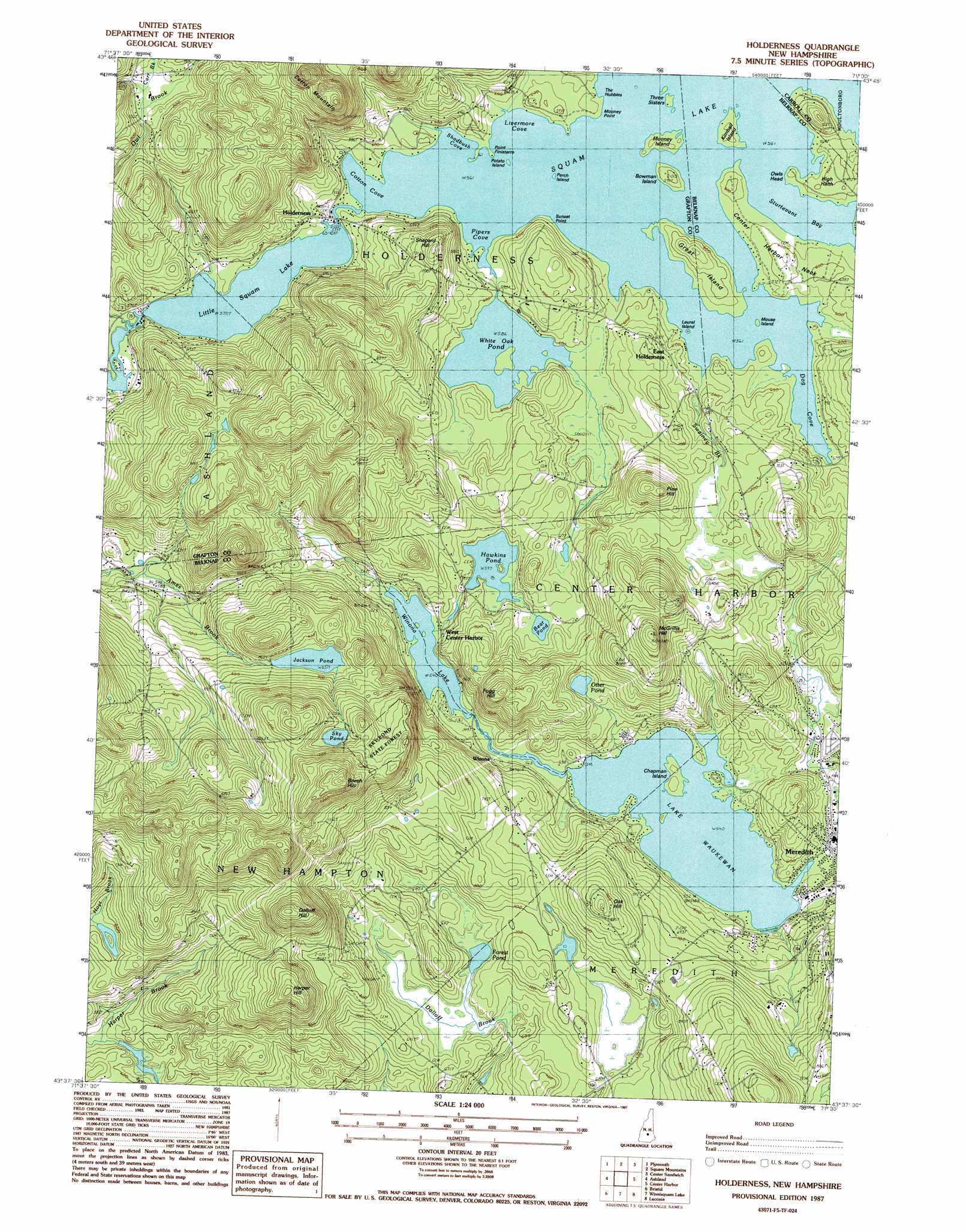
Holderness Topo Map New Hampshire
To zoom in, hover over the map of Holderness
USGS Topo Quad 43071f5 - 1:24,000 scale
| Topo Map Name: | Holderness |
| USGS Topo Quad ID: | 43071f5 |
| Print Size: | ca. 21 1/4" wide x 27" high |
| Southeast Coordinates: | 43.625° N latitude / 71.5° W longitude |
| Map Center Coordinates: | 43.6875° N latitude / 71.5625° W longitude |
| U.S. State: | NH |
| Filename: | o43071f5.jpg |
| Download Map JPG Image: | Holderness topo map 1:24,000 scale |
| Map Type: | Topographic |
| Topo Series: | 7.5´ |
| Map Scale: | 1:24,000 |
| Source of Map Images: | United States Geological Survey (USGS) |
| Alternate Map Versions: |
Holderness NH 1987, updated 1987 Download PDF Buy paper map Holderness NH 2012 Download PDF Buy paper map Holderness NH 2015 Download PDF Buy paper map |
1:24,000 Topo Quads surrounding Holderness
Mount Kineo |
Woodstock |
Waterville Valley |
Mount Tripyramid |
Mount Chocorua |
Rumney |
Plymouth |
Squam Mountains |
Center Sandwich |
Tamworth |
Newfound Lake |
Ashland |
Holderness |
Center Harbor |
Melvin Village |
Danbury |
Bristol |
Winnisquam Lake |
Laconia |
West Alton |
Andover |
Franklin |
Northfield |
Belmont |
Gilmanton Ironworks |
> Back to 43071e1 at 1:100,000 scale
> Back to 43070a1 at 1:250,000 scale
> Back to U.S. Topo Maps home
Holderness topo map: Gazetteer
Holderness: Airports
Smiling Jack Heliport elevation 163m 534′Holderness: Bays
Cotton Cove elevation 171m 561′Dog Cove elevation 171m 561′
Livernore Cove elevation 171m 561′
Pipers Cove elevation 171m 561′
Sahdbush Cove elevation 171m 561′
Shadbush Cove elevation 171m 561′
Sturtevant Bay elevation 171m 561′
Holderness: Bridges
Squam River Bridge elevation 172m 564′Holderness: Capes
Center Harbor Neck elevation 183m 600′Finisterre elevation 171m 561′
Owls Head elevation 172m 564′
Sunset Point elevation 171m 561′
Holderness: Dams
Hawkins Pond Dam elevation 182m 597′Lake Waukewan Dam elevation 165m 541′
Meredith Reservoir Dam elevation 240m 787′
White Oak Pond Dam elevation 177m 580′
Holderness: Islands
Bowman Island elevation 182m 597′Chapman Island elevation 168m 551′
Great Island elevation 198m 649′
Kimball Island elevation 178m 583′
Laurel Island elevation 171m 561′
Mooney Island elevation 176m 577′
Mouse Island elevation 171m 561′
Perch Island elevation 171m 561′
Potato Island elevation 171m 561′
The Hubbles elevation 171m 561′
Three Sisters Island elevation 171m 561′
Holderness: Lakes
Bear Pond elevation 187m 613′Forest Pond elevation 188m 616′
Jackson Pond elevation 259m 849′
Lake Waukewan elevation 164m 538′
Little Squam Lake elevation 172m 564′
Otter Pond elevation 206m 675′
Sky Pond elevation 327m 1072′
Squam Lake elevation 171m 561′
Winona Lake elevation 164m 538′
Holderness: Parks
Sky Pond State Forest elevation 336m 1102′Holderness: Populated Places
East Holderness elevation 190m 623′Holderness elevation 180m 590′
Meredith elevation 158m 518′
West Center Harbor elevation 169m 554′
Winona elevation 174m 570′
Holderness: Reservoirs
Hawkins Pond elevation 182m 597′Lake Waukewan elevation 165m 541′
Meredith Reservoir elevation 240m 787′
White Oak Pond elevation 177m 580′
Holderness: Streams
Carr Brook elevation 224m 734′Hoyt Brook elevation 177m 580′
Owl Brook elevation 177m 580′
Swainey Brook elevation 171m 561′
Holderness: Summits
Beech Hill elevation 439m 1440′Cotton Mountain elevation 363m 1190′
Dolloff Hill elevation 385m 1263′
Fogg Hill elevation 293m 961′
Harper Hill elevation 367m 1204′
High Haith elevation 184m 603′
McGrillis Hill elevation 327m 1072′
Oak Hill elevation 291m 954′
Pine Hill elevation 280m 918′
Shepard Hill elevation 255m 836′
Holderness digital topo map on disk
Buy this Holderness topo map showing relief, roads, GPS coordinates and other geographical features, as a high-resolution digital map file on DVD:
Maine, New Hampshire, Rhode Island & Eastern Massachusetts
Buy digital topo maps: Maine, New Hampshire, Rhode Island & Eastern Massachusetts