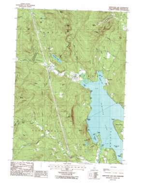
Newfound Lake Topo Map New Hampshire
To zoom in, hover over the map of Newfound Lake
USGS Topo Quad 43071f7 - 1:24,000 scale
| Topo Map Name: | Newfound Lake |
| USGS Topo Quad ID: | 43071f7 |
| Print Size: | ca. 21 1/4" wide x 27" high |
| Southeast Coordinates: | 43.625° N latitude / 71.75° W longitude |
| Map Center Coordinates: | 43.6875° N latitude / 71.8125° W longitude |
| U.S. State: | NH |
| Filename: | o43071f7.jpg |
| Download Map JPG Image: | Newfound Lake topo map 1:24,000 scale |
| Map Type: | Topographic |
| Topo Series: | 7.5´ |
| Map Scale: | 1:24,000 |
| Source of Map Images: | United States Geological Survey (USGS) |
| Alternate Map Versions: |
Newfound Lake NH 1987, updated 1987 Download PDF Buy paper map Newfound Lake NH 1998, updated 2001 Download PDF Buy paper map Newfound Lake NH 2012 Download PDF Buy paper map Newfound Lake NH 2015 Download PDF Buy paper map |
1:24,000 Topo Quads surrounding Newfound Lake
> Back to 43071e1 at 1:100,000 scale
> Back to 43070a1 at 1:250,000 scale
> Back to U.S. Topo Maps home
Newfound Lake topo map: Gazetteer
Newfound Lake: Bays
Hebron Bay elevation 179m 587′Hornet Cove elevation 179m 587′
Pasquaney Bay elevation 179m 587′
Sanborn Bay elevation 179m 587′
Newfound Lake: Benches
Rogers Ledge elevation 181m 593′Newfound Lake: Capes
Whittemore Point elevation 179m 587′Newfound Lake: Dams
Spectacle Pond Dam elevation 250m 820′Newfound Lake: Falls
Welton Falls elevation 309m 1013′Newfound Lake: Forests
Welton Falls State Forest elevation 375m 1230′Newfound Lake: Islands
Belle Island elevation 179m 587′Loon Island elevation 179m 587′
Newfound Lake: Lakes
Goose Pond elevation 211m 692′Little Pond elevation 436m 1430′
Newfound Lake elevation 179m 587′
Newfound Lake: Parks
Hebron Village Historic District elevation 186m 610′Wellington State Park elevation 181m 593′
Newfound Lake: Pillars
Sculptured Rocks elevation 219m 718′Newfound Lake: Populated Places
East Hebron elevation 201m 659′Groton elevation 194m 636′
Hebron elevation 189m 620′
Nuttings Beach elevation 179m 587′
Newfound Lake: Post Offices
East Hebron Post Office elevation 194m 636′Hebron Post Office elevation 190m 623′
Newfound Lake: Reservoirs
Spectacle Pond elevation 250m 820′Newfound Lake: Ridges
Tenney Hill elevation 294m 964′Newfound Lake: Streams
Bailey Brook elevation 432m 1417′Black Brook elevation 181m 593′
Bog Brook elevation 180m 590′
Brock Brook elevation 249m 816′
Chesley Brook elevation 273m 895′
Cilley Brook elevation 200m 656′
Clark Brook elevation 249m 816′
Cockermouth River elevation 179m 587′
Fretts Brook elevation 198m 649′
Georges Brook elevation 180m 590′
Hardy Brook elevation 189m 620′
Templeton Brook elevation 269m 882′
Town Brook elevation 221m 725′
Wise Brook elevation 182m 597′
Newfound Lake: Summits
Bailey Hill elevation 458m 1502′Bald Knob elevation 606m 1988′
Bear Mountain elevation 532m 1745′
Hobart Hill elevation 336m 1102′
Hoyt Hill elevation 322m 1056′
Jewell Hill elevation 607m 1991′
Little Sugarloaf elevation 276m 905′
Mount Crosby elevation 675m 2214′
Oregon Mountain elevation 677m 2221′
Rolfe Hill elevation 450m 1476′
Sugarloaf elevation 414m 1358′
Tenney Mountain elevation 680m 2230′
Newfound Lake: Trails
Melton Falls Trail elevation 449m 1473′Newfound Lake digital topo map on disk
Buy this Newfound Lake topo map showing relief, roads, GPS coordinates and other geographical features, as a high-resolution digital map file on DVD:
Maine, New Hampshire, Rhode Island & Eastern Massachusetts
Buy digital topo maps: Maine, New Hampshire, Rhode Island & Eastern Massachusetts


