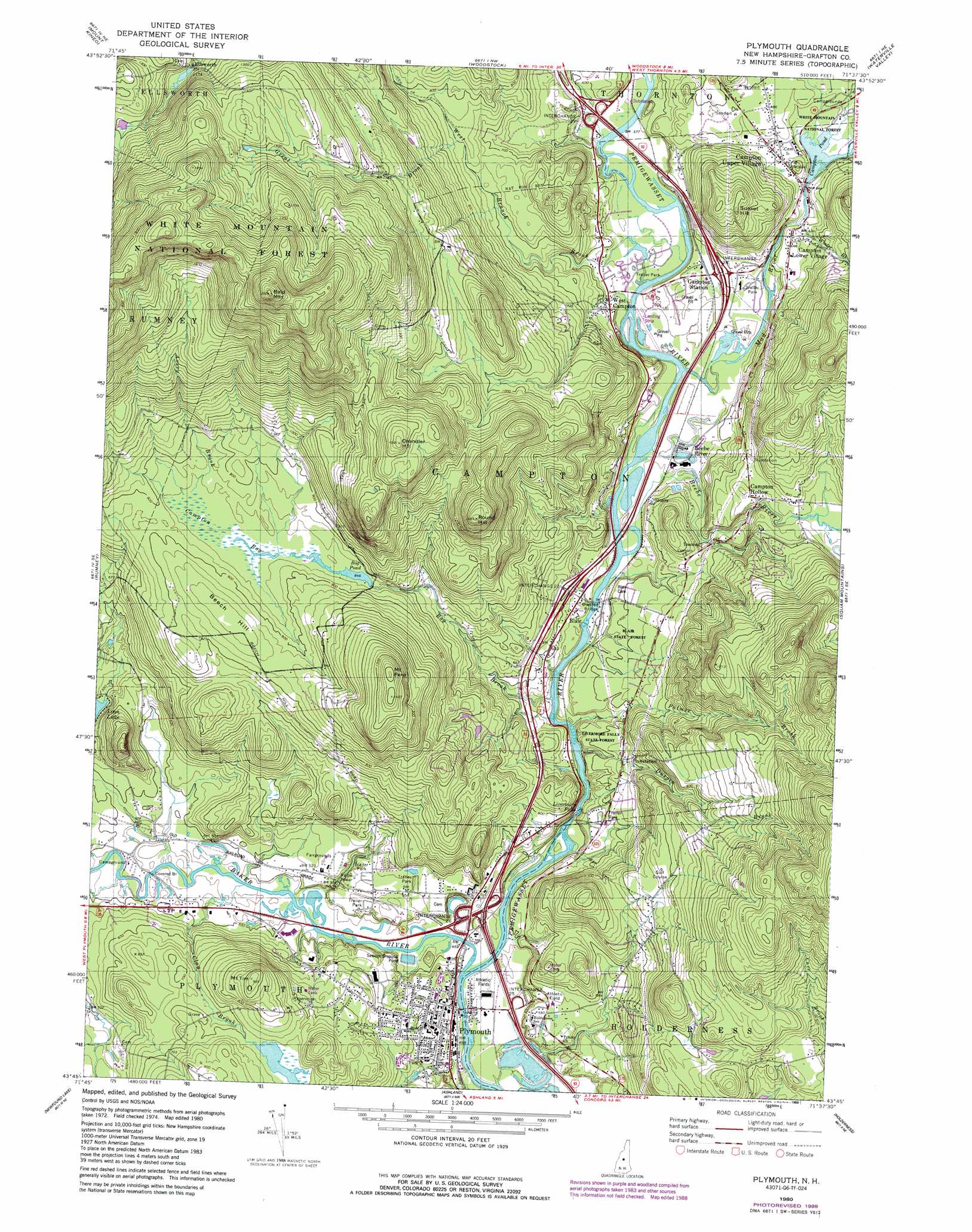
Plymouth Topo Map New Hampshire
To zoom in, hover over the map of Plymouth
USGS Topo Quad 43071g6 - 1:24,000 scale
| Topo Map Name: | Plymouth |
| USGS Topo Quad ID: | 43071g6 |
| Print Size: | ca. 21 1/4" wide x 27" high |
| Southeast Coordinates: | 43.75° N latitude / 71.625° W longitude |
| Map Center Coordinates: | 43.8125° N latitude / 71.6875° W longitude |
| U.S. State: | NH |
| Filename: | o43071g6.jpg |
| Download Map JPG Image: | Plymouth topo map 1:24,000 scale |
| Map Type: | Topographic |
| Topo Series: | 7.5´ |
| Map Scale: | 1:24,000 |
| Source of Map Images: | United States Geological Survey (USGS) |
| Alternate Map Versions: |
Plymouth NH 1980, updated 1981 Download PDF Buy paper map Plymouth NH 1980, updated 1989 Download PDF Buy paper map Plymouth NH 1995, updated 2000 Download PDF Buy paper map Plymouth NH 2012 Download PDF Buy paper map Plymouth NH 2015 Download PDF Buy paper map |
| FStopo: | US Forest Service topo Plymouth is available: Download FStopo PDF Download FStopo TIF |
1:24,000 Topo Quads surrounding Plymouth
East Haverhill |
Mount Moosilauke |
Lincoln |
Mount Osceola |
Mount Carrigan |
Warren |
Mount Kineo |
Woodstock |
Waterville Valley |
Mount Tripyramid |
Wentworth |
Rumney |
Plymouth |
Squam Mountains |
Center Sandwich |
Mount Cardigan |
Newfound Lake |
Ashland |
Holderness |
Center Harbor |
Grafton |
Danbury |
Bristol |
Winnisquam Lake |
Laconia |
> Back to 43071e1 at 1:100,000 scale
> Back to 43070a1 at 1:250,000 scale
> Back to U.S. Topo Maps home
Plymouth topo map: Gazetteer
Plymouth: Bridges
Blair Bridge elevation 162m 531′Smith Bridge elevation 143m 469′
Turkey Jims Bridge elevation 165m 541′
Plymouth: Crossings
Interchange 25 elevation 146m 479′Interchange 26 elevation 256m 839′
Interchange 27 elevation 183m 600′
Interchange 28 elevation 183m 600′
Interchange 29 elevation 176m 577′
Plymouth: Dams
Campton Bog Pond Dam elevation 264m 866′Campton Pond Dam elevation 196m 643′
Fox Pond Dam elevation 179m 587′
Milo Lake Dam elevation 165m 541′
Plymouth: Falls
Livermore Falls elevation 178m 583′Plymouth: Flats
The Plains elevation 179m 587′Plymouth: Lakes
Bog Pond elevation 259m 849′Plymouth: Parks
Plymouth Historic District elevation 166m 544′Plymouth Town Common elevation 158m 518′
Rowbartwood Marsh Wildlife Management Area elevation 259m 849′
Plymouth: Populated Places
Beebe River elevation 164m 538′Blair elevation 164m 538′
Campton Hollow elevation 235m 770′
Campton Lower Village elevation 191m 626′
Campton Station elevation 177m 580′
Campton Upper Village elevation 205m 672′
Ellsworth elevation 348m 1141′
Plymouth elevation 157m 515′
West Campton elevation 178m 583′
Plymouth: Post Offices
Plymouth Post Office elevation 168m 551′Plymouth: Reservoirs
Campton Bog Pond elevation 264m 866′Campton Pond elevation 196m 643′
Fox Pond elevation 179m 587′
Milo Lake elevation 165m 541′
Plymouth: Ridges
Beech Hill elevation 294m 964′Plymouth: Streams
Avery Brook elevation 260m 853′Baker River elevation 142m 465′
Beebe River elevation 162m 531′
Bog Brook elevation 155m 508′
Clay Brook elevation 146m 479′
Durgin Brook elevation 163m 534′
Great Brook elevation 229m 751′
Mad River elevation 162m 531′
Palmer Brook elevation 178m 583′
West Branch Brook elevation 164m 538′
Winter Brook elevation 191m 626′
Plymouth: Summits
Bald Mountain elevation 662m 2171′Chandler Hill elevation 476m 1561′
Mount Pero elevation 433m 1420′
Mount Tim elevation 289m 948′
Round Hill elevation 448m 1469′
Sunset Hill elevation 299m 980′
Plymouth: Swamps
Campton Bog elevation 260m 853′Plymouth digital topo map on disk
Buy this Plymouth topo map showing relief, roads, GPS coordinates and other geographical features, as a high-resolution digital map file on DVD:
Maine, New Hampshire, Rhode Island & Eastern Massachusetts
Buy digital topo maps: Maine, New Hampshire, Rhode Island & Eastern Massachusetts