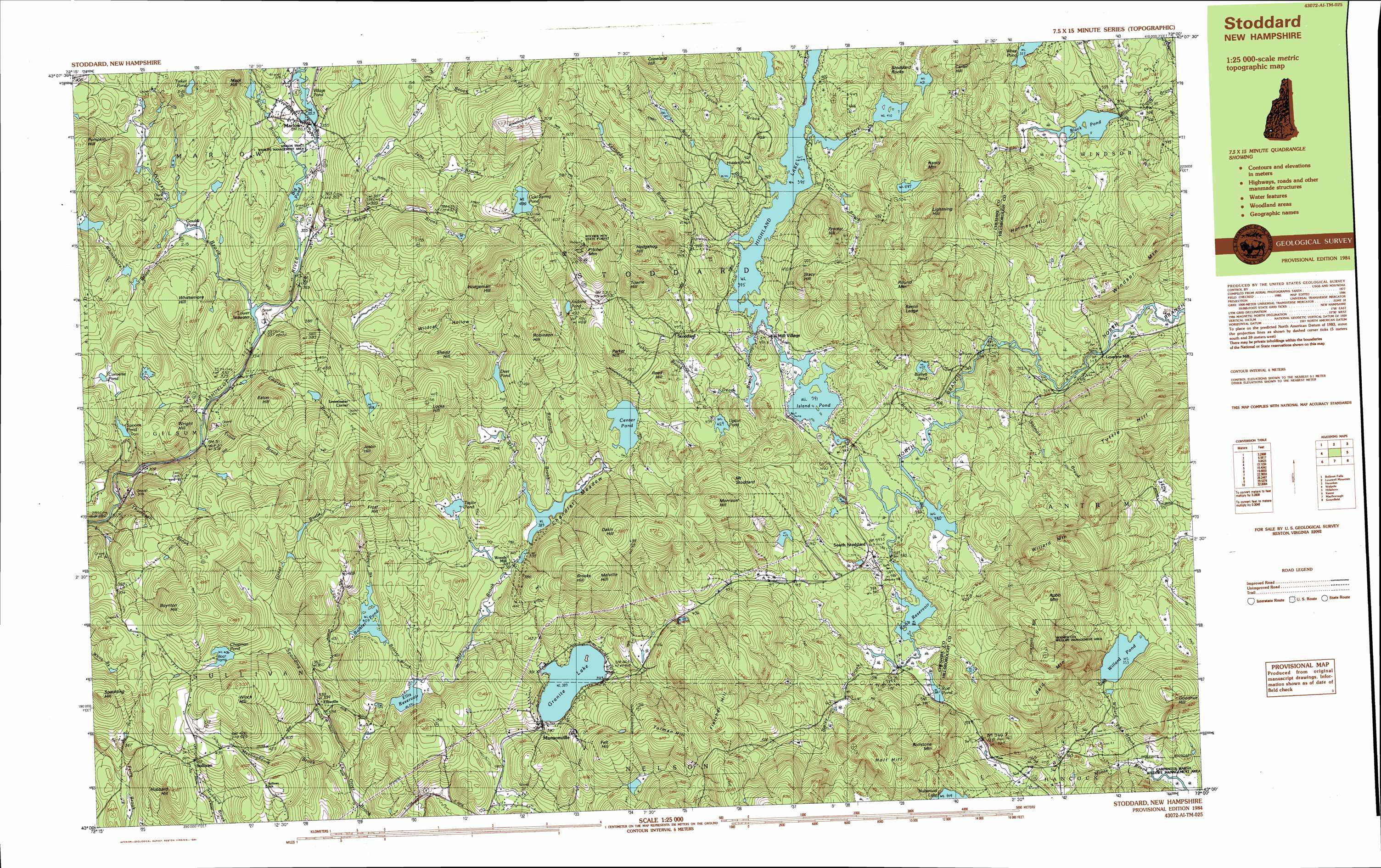
Stoddard Topo Map New Hampshire
To zoom in, hover over the map of Stoddard
USGS Topo Quad 43072a1 - 1:25,000 scale
| Topo Map Name: | Stoddard |
| USGS Topo Quad ID: | 43072a1 |
| Print Size: | ca. 39" wide x 24" high |
| Southeast Coordinates: | 43° N latitude / 72° W longitude |
| Map Center Coordinates: | 43.0625° N latitude / 72.125° W longitude |
| U.S. State: | NH |
| Filename: | k43072a1.jpg |
| Download Map JPG Image: | Stoddard topo map 1:25,000 scale |
| Map Type: | Topographic |
| Topo Series: | 7.5´x15´ |
| Map Scale: | 1:25,000 |
| Source of Map Images: | United States Geological Survey (USGS) |
| Alternate Map Versions: |
Stoddard NH 1984, updated 1984 Download PDF Buy paper map |
1:24,000 Topo Quads surrounding Stoddard
Claremont South |
Sunapee Lakes |
Bradford |
Warner |
|
Alstead |
Washington |
Hillsboro Upper Village |
Henniker |
|
Gilsum |
Stoddard |
Hillsboro |
Deering |
|
Keene |
Dublin |
Peterborough North |
Greenfield |
|
West Swanzey |
Monadnock Mountain |
Peterborough South |
Greenville |
> Back to 43072a1 at 1:100,000 scale
> Back to 43072a1 at 1:250,000 scale
> Back to U.S. Topo Maps home
Stoddard topo map: Gazetteer
Stoddard: Bridges
Stone Arch Bridge elevation 348m 1141′Stoddard: Dams
Black Pond Dam elevation 329m 1079′Chandler Meadow Pond Dam elevation 391m 1282′
Cold Spring Pond Dam elevation 499m 1637′
Granite Lake Dam elevation 390m 1279′
Highland Lake South Outlet Dam elevation 396m 1299′
Island Pond Dam elevation 391m 1282′
Pickerel Creek Dam elevation 410m 1345′
Rice Brook Dam elevation 477m 1564′
Robb Reservoir Dam elevation 384m 1259′
Spoons Pond Dam elevation 363m 1190′
Village Pond Dam elevation 354m 1161′
Willard Pond Dam elevation 354m 1161′
Stoddard: Forests
Pitcher Mountain State Forest elevation 647m 2122′Stoddard: Lakes
Barrett Pond elevation 405m 1328′Big Pond elevation 353m 1158′
Bolster Pond elevation 409m 1341′
Center Pond elevation 404m 1325′
Chapman Pond elevation 406m 1332′
Converse Pond elevation 364m 1194′
Duck Hole elevation 358m 1174′
Gould Pond elevation 346m 1135′
Hidded Pond elevation 449m 1473′
Highland Lake elevation 395m 1295′
Lower Stillwater elevation 334m 1095′
Rye Pond elevation 388m 1272′
Taylor Pond elevation 410m 1345′
Tinker Pond elevation 430m 1410′
Trout Pond elevation 487m 1597′
Upton Pond elevation 429m 1407′
White Pond elevation 325m 1066′
Willard Pond elevation 353m 1158′
Stoddard: Parks
DePierrefeu-Willard Pond Sanctuary elevation 353m 1158′Kinson State Wildlife Management Area elevation 391m 1282′
Stoddard: Populated Places
Ellisville elevation 339m 1112′Leominster Corner elevation 459m 1505′
Loverens Mill elevation 313m 1026′
Marlow elevation 354m 1161′
Mill Village elevation 393m 1289′
Munsonville elevation 384m 1259′
South Stoddard elevation 393m 1289′
Stoddard elevation 432m 1417′
Sullivan elevation 432m 1417′
Woods Mill elevation 389m 1276′
Stoddard: Reservoirs
Black Pond elevation 329m 1079′Chandler Meadow Pond elevation 391m 1282′
Cold Spring Pond elevation 499m 1637′
Ellis Reservoir elevation 373m 1223′
Granite Lake elevation 390m 1279′
Island Pond elevation 391m 1282′
Pickerel Creek Pond elevation 410m 1345′
Rice Brook Pond elevation 477m 1564′
Robb Reservoir elevation 384m 1259′
Spoons Pond elevation 363m 1190′
Village Pond elevation 354m 1161′
Stoddard: Streams
Abbott Brook elevation 353m 1158′Bailey Brook elevation 389m 1276′
Bolster Brook elevation 372m 1220′
Butler Brook elevation 352m 1154′
Carr Brook elevation 395m 1295′
Davis Brook elevation 389m 1276′
Dead Brook elevation 395m 1295′
Decul Brook elevation 395m 1295′
Emerson Brook elevation 329m 1079′
Fisher Brook elevation 401m 1315′
Fox Brook elevation 385m 1263′
Grassy Brook elevation 334m 1095′
Great Brook elevation 379m 1243′
Jefts Brook elevation 418m 1371′
Kennedy Brook elevation 395m 1295′
Meetinghouse Brook elevation 312m 1023′
Morse Brook elevation 376m 1233′
Pickerel Creek elevation 395m 1295′
Rice Brook elevation 396m 1299′
Robinson Brook elevation 389m 1276′
Salmon Brook elevation 324m 1062′
Seward Brook elevation 409m 1341′
Spaulding Brook elevation 311m 1020′
Thompson Brook elevation 398m 1305′
Trout Brook elevation 310m 1017′
Upton Brook elevation 395m 1295′
Whittemore Brook elevation 346m 1135′
Stoddard: Summits
Bacon Ledge elevation 570m 1870′Bald Mountain elevation 617m 2024′
Boynton Hill elevation 529m 1735′
Brooks Hill elevation 586m 1922′
Carter Hill elevation 512m 1679′
Copeland Hill elevation 606m 1988′
Dakin Hill elevation 595m 1952′
Eaton Hill elevation 461m 1512′
Felt Hill elevation 532m 1745′
Fletcher Hill elevation 595m 1952′
Frost Hill elevation 518m 1699′
Goodhue Hill elevation 487m 1597′
Hedgehog Hill elevation 529m 1735′
Hedgehog Hill elevation 575m 1886′
Hodgeman Hill elevation 626m 2053′
Holmes Hill elevation 480m 1574′
Holt Hill elevation 581m 1906′
Hubbard Hill elevation 450m 1476′
Hubbard Hill elevation 577m 1893′
Joslin Hill elevation 529m 1735′
Lightning Hill elevation 582m 1909′
Locke Hill elevation 535m 1755′
Mack Hill elevation 442m 1450′
Melville Hill elevation 584m 1916′
Morrison Hill elevation 581m 1906′
Mount Stoddard elevation 542m 1778′
Nancy Mountain elevation 523m 1715′
Parker Hill elevation 541m 1774′
Pitcher Mountain elevation 653m 2142′
Proctor Hill elevation 524m 1719′
Pumpkin Hill elevation 457m 1499′
Reed Hill elevation 466m 1528′
Robb Mountain elevation 554m 1817′
Robinson Hill elevation 566m 1856′
Rollstone Mountain elevation 516m 1692′
Round Mountain elevation 592m 1942′
Shedd Hill elevation 509m 1669′
Spaulding Hill elevation 487m 1597′
Stacy Hill elevation 538m 1765′
Stoddard Rocks elevation 476m 1561′
Tolman Hill elevation 572m 1876′
Towne Hill elevation 565m 1853′
Towne Hill elevation 582m 1909′
Tuttle Hill elevation 535m 1755′
Whittemore Hill elevation 410m 1345′
Willard Mountain elevation 582m 1909′
Winch Hill elevation 500m 1640′
Windsor Mountain elevation 487m 1597′
Wright Hill elevation 395m 1295′
Stoddard: Swamps
Chandler Meadow elevation 390m 1279′Stoddard: Valleys
Wildcat Hollow elevation 433m 1420′Stoddard digital topo map on disk
Buy this Stoddard topo map showing relief, roads, GPS coordinates and other geographical features, as a high-resolution digital map file on DVD:
New York, Vermont, Connecticut & Western Massachusetts
Buy digital topo maps: New York, Vermont, Connecticut & Western Massachusetts