Stratton Mountain Topo Map Vermont
To zoom in, hover over the map of Stratton Mountain
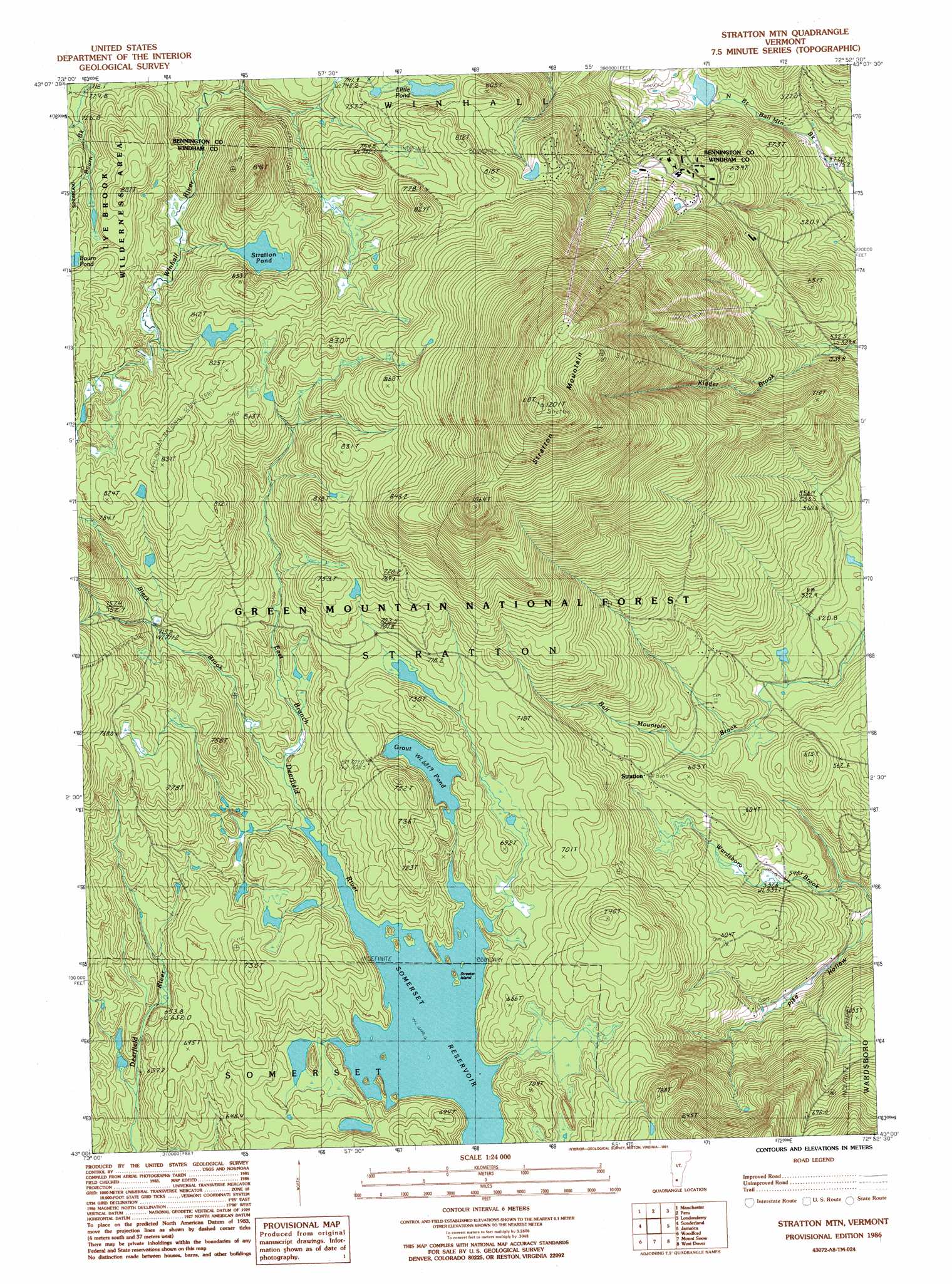
USGS Topo Quad 43072a8 - 1:24,000 scale
| Topo Map Name: | Stratton Mountain |
| USGS Topo Quad ID: | 43072a8 |
| Print Size: | ca. 21 1/4" wide x 27" high |
| Southeast Coordinates: | 43° N latitude / 72.875° W longitude |
| Map Center Coordinates: | 43.0625° N latitude / 72.9375° W longitude |
| U.S. State: | VT |
| Filename: | o43072a8.jpg |
| Download Map JPG Image: | Stratton Mountain topo map 1:24,000 scale |
| Map Type: | Topographic |
| Topo Series: | 7.5´ |
| Map Scale: | 1:24,000 |
| Source of Map Images: | United States Geological Survey (USGS) |
| Alternate Map Versions: |
Stratton Mtn VT 1986, updated 1987 Download PDF Buy paper map Stratton Mtn VT 1986, updated 1991 Download PDF Buy paper map Stratton Mtn VT 1986, updated 1991 Download PDF Buy paper map Stratton Mountain VT 1997, updated 2000 Download PDF Buy paper map Stratton Mountain VT 2012 Download PDF Buy paper map Stratton Mountain VT 2015 Download PDF Buy paper map |
| FStopo: | US Forest Service topo Stratton Mountain is available: Download FStopo PDF Download FStopo TIF |
1:24,000 Topo Quads surrounding Stratton Mountain
Pawlet |
Dorset |
Danby |
Weston |
Andover |
West Rupert |
Manchester |
Peru |
Londonderry |
|
Arlington |
Sunderland |
Stratton Mountain |
Jamaica |
|
Bennington |
Woodford |
Mount Snow |
West Dover |
|
Pownal |
Stamford |
Readsboro |
Jacksonville |
> Back to 43072a1 at 1:100,000 scale
> Back to 43072a1 at 1:250,000 scale
> Back to U.S. Topo Maps home
Stratton Mountain topo map: Gazetteer
Stratton Mountain: Dams
Gulf Brook Reservoir Dam elevation 784m 2572′Stratton Mountain Lake Dam elevation 518m 1699′
Stratton Mountain: Islands
Streeter Island elevation 649m 2129′Stratton Mountain: Lakes
Grout Pond elevation 682m 2237′Little Pond elevation 753m 2470′
Stratton Pond elevation 783m 2568′
Stratton Mountain: Pillars
Daniel Webster Historical Monument elevation 705m 2312′Stratton Mountain: Populated Places
Stratton elevation 595m 1952′Stratton Mountain elevation 610m 2001′
Stratton Mountain: Reservoirs
Gulf Brook Reservoir elevation 784m 2572′Stratton Mountain Lake elevation 518m 1699′
Stratton Mountain: Streams
Black Brook elevation 653m 2142′Stratton Mountain: Summits
Stratton Mountain elevation 1193m 3914′Stratton Mountain: Trails
Cooridor 7 elevation 721m 2365′Deerfield Trail elevation 668m 2191′
Stratton Mountain: Valleys
Pike Hollow elevation 494m 1620′Stratton Mountain digital topo map on disk
Buy this Stratton Mountain topo map showing relief, roads, GPS coordinates and other geographical features, as a high-resolution digital map file on DVD:
New York, Vermont, Connecticut & Western Massachusetts
Buy digital topo maps: New York, Vermont, Connecticut & Western Massachusetts