Alstead Topo Map New Hampshire
To zoom in, hover over the map of Alstead
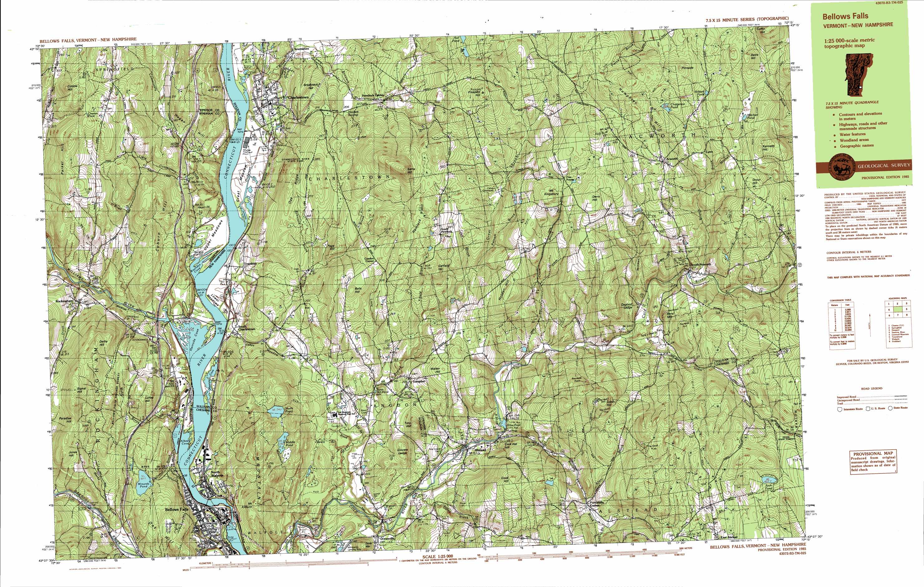
USGS Topo Quad 43072b3 - 1:25,000 scale
| Topo Map Name: | Alstead |
| USGS Topo Quad ID: | 43072b3 |
| Print Size: | ca. 39" wide x 24" high |
| Southeast Coordinates: | 43.125° N latitude / 72.25° W longitude |
| Map Center Coordinates: | 43.1875° N latitude / 72.375° W longitude |
| U.S. State: | NH |
| Filename: | k43072b3.jpg |
| Download Map JPG Image: | Alstead topo map 1:25,000 scale |
| Map Type: | Topographic |
| Topo Series: | 7.5´x15´ |
| Map Scale: | 1:25,000 |
| Source of Map Images: | United States Geological Survey (USGS) |
| Alternate Map Versions: |
Bellows Falls VT 1985, updated 1985 Download PDF Buy paper map Bellows Falls VT 1985, updated 1985 Download PDF Buy paper map |
1:24,000 Topo Quads surrounding Alstead
Cavendish |
Claremont North |
Sunapee Lake North |
||
Chester |
Claremont South |
Sunapee Lakes |
||
Saxtons River |
Alstead |
Washington |
||
Westminster West |
Gilsum |
Stoddard |
||
Putney |
Keene |
Dublin |
> Back to 43072a1 at 1:100,000 scale
> Back to 43072a1 at 1:250,000 scale
> Back to U.S. Topo Maps home
Alstead topo map: Gazetteer
Alstead: Benches
Glovers Ledge elevation 248m 813′Osgood Ledge elevation 391m 1282′
The Stairs elevation 97m 318′
Alstead: Bridges
First Connecticut River Bridge elevation 79m 259′Hall Covered Bridge elevation 122m 400′
McDermott Bridge elevation 190m 623′
Prentiss Bridge elevation 164m 538′
Worrall Covered Bridge elevation 104m 341′
Alstead: Canals
Bellows Falls Canal elevation 91m 298′Alstead: Crossings
Interchange 6 elevation 157m 515′Alstead: Dams
Bates Mill Pond Dam elevation 151m 495′Bellows Falls Dam elevation 83m 272′
Clay Brook Dam elevation 123m 403′
Vilas Pool Dam elevation 173m 567′
Alstead: Flats
Great Meadow elevation 89m 291′Lover Meadow elevation 90m 295′
Upper Meadow elevation 91m 298′
Alstead: Forests
Bellows Falls Village Forest elevation 227m 744′Alstead: Lakes
Arch Pond elevation 427m 1400′Chatterton Pond elevation 482m 1581′
Hilliard Pond elevation 447m 1466′
Middle Pond elevation 230m 754′
Mitchell Pond elevation 431m 1414′
North Pond elevation 245m 803′
Alstead: Parks
Acworth Town Common elevation 468m 1535′Bellows Falls Downtown Historic District elevation 96m 314′
Charlestown Main Street Historic District elevation 116m 380′
Connecticut River State Park elevation 276m 905′
Drewsville Village Green elevation 148m 485′
The Square elevation 92m 301′
Alstead: Populated Places
Acworth elevation 445m 1459′Alstead elevation 147m 482′
Bellows Falls elevation 95m 311′
Charlestown elevation 119m 390′
Drewsville elevation 146m 479′
Hemlock Center elevation 244m 800′
Langdon elevation 209m 685′
Lynn elevation 440m 1443′
North Walpole elevation 90m 295′
Rockingham elevation 149m 488′
Snumshire elevation 144m 472′
South Acworth elevation 253m 830′
South Charlestown elevation 100m 328′
South Hemlock elevation 376m 1233′
Trapshire elevation 99m 324′
Alstead: Post Offices
Bellows Falls Post Office elevation 93m 305′Charlestown Post Office elevation 116m 380′
Alstead: Reservoirs
Clay Brook Reservoir elevation 123m 403′Connecticut River Reservoir elevation 83m 272′
Minards Pond elevation 187m 613′
Vilas Pool elevation 173m 567′
Alstead: Ridges
Oak Ridge elevation 292m 958′Alstead: Streams
Benware Brook elevation 143m 469′Bowers Brook elevation 250m 820′
Camp Brook elevation 252m 826′
Clay Brook elevation 88m 288′
Commissary Brook elevation 85m 278′
Crane Brook elevation 195m 639′
Darby Brook elevation 140m 459′
Dickerson Brook elevation 86m 282′
Gravel Brook elevation 84m 275′
Great Brook elevation 97m 318′
Great Brook elevation 216m 708′
Hackett Brook elevation 125m 410′
Jabes Hackett Brook elevation 88m 288′
Little Brook elevation 157m 515′
Little Commissary Brook elevation 102m 334′
Meadow Brook elevation 88m 288′
Milliken Brook elevation 390m 1279′
Milliken Brook elevation 222m 728′
Mountain Brook elevation 85m 278′
O'Brien Brook elevation 89m 291′
Robinson Brook elevation 281m 921′
Warren Brook elevation 156m 511′
Williams River elevation 84m 275′
Alstead: Summits
Balls Hill elevation 343m 1125′Beryl Mountain elevation 336m 1102′
Breakneck Hill elevation 268m 879′
Cobb Hill elevation 478m 1568′
Cobble Hill elevation 365m 1197′
Coburn Hill elevation 296m 971′
Cock Hat Hill elevation 178m 583′
Coffin Hill elevation 582m 1909′
Colley Hill elevation 244m 800′
Cook Hill elevation 362m 1187′
Darby Hill elevation 332m 1089′
Davis Hill elevation 506m 1660′
Derry Hill elevation 497m 1630′
Drew Mountain elevation 220m 721′
Fall Mountain elevation 300m 984′
Garfield Hill elevation 375m 1230′
Grout Hill elevation 472m 1548′
Hemlock Hill elevation 409m 1341′
Hogan Hill elevation 285m 935′
Holden Hill elevation 401m 1315′
Humphrey Hill elevation 542m 1778′
Jones Hill elevation 359m 1177′
Kennedy Hill elevation 475m 1558′
Mount Kilburn elevation 338m 1108′
Oak Hill elevation 259m 849′
Page Hill elevation 285m 935′
Paradise Hill elevation 362m 1187′
Parker Hill elevation 369m 1210′
Pinnacle elevation 544m 1784′
Prospect Hill elevation 436m 1430′
Sams Hill elevation 503m 1650′
Signal Hill elevation 380m 1246′
Tory Hill elevation 283m 928′
Walker Hill elevation 297m 974′
Alstead: Tunnels
Boston and Main Railroad Tunnel elevation 96m 314′Alstead digital topo map on disk
Buy this Alstead topo map showing relief, roads, GPS coordinates and other geographical features, as a high-resolution digital map file on DVD:
New York, Vermont, Connecticut & Western Massachusetts
Buy digital topo maps: New York, Vermont, Connecticut & Western Massachusetts