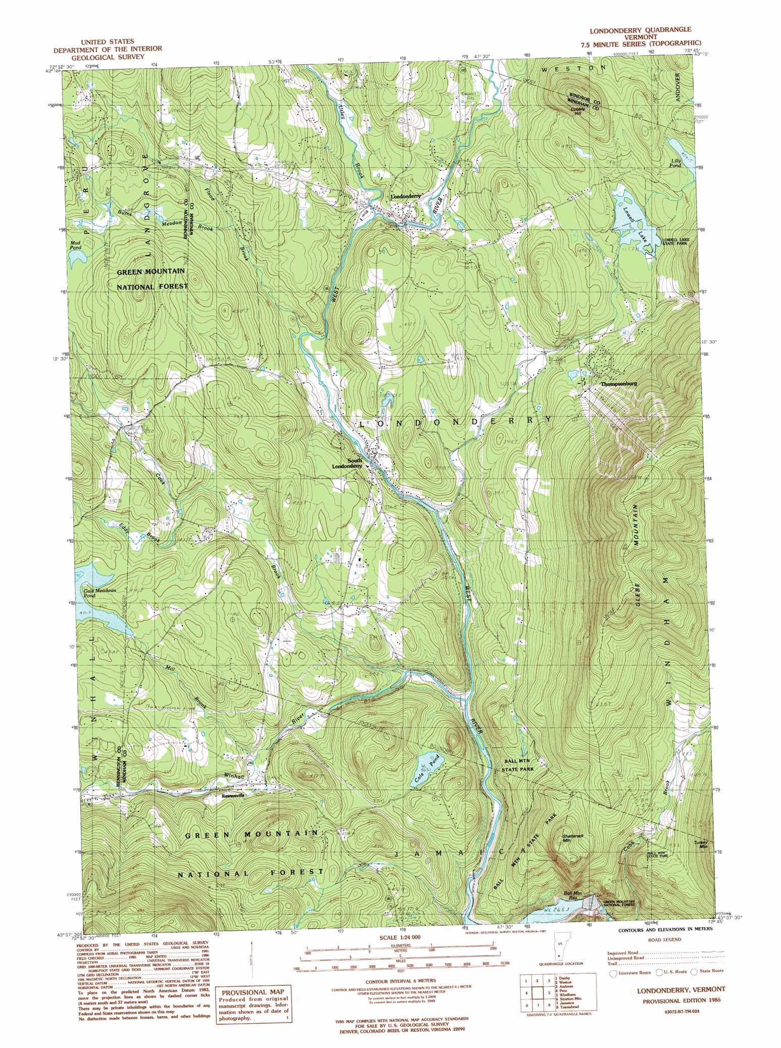
Londonderry Topo Map Vermont
To zoom in, hover over the map of Londonderry
USGS Topo Quad 43072b7 - 1:24,000 scale
| Topo Map Name: | Londonderry |
| USGS Topo Quad ID: | 43072b7 |
| Print Size: | ca. 21 1/4" wide x 27" high |
| Southeast Coordinates: | 43.125° N latitude / 72.75° W longitude |
| Map Center Coordinates: | 43.1875° N latitude / 72.8125° W longitude |
| U.S. State: | VT |
| Filename: | o43072b7.jpg |
| Download Map JPG Image: | Londonderry topo map 1:24,000 scale |
| Map Type: | Topographic |
| Topo Series: | 7.5´ |
| Map Scale: | 1:24,000 |
| Source of Map Images: | United States Geological Survey (USGS) |
| Alternate Map Versions: |
Londonderry VT 1986, updated 1987 Download PDF Buy paper map Londonderry VT 1997, updated 2000 Download PDF Buy paper map Londonderry VT 2012 Download PDF Buy paper map Londonderry VT 2015 Download PDF Buy paper map |
| FStopo: | US Forest Service topo Londonderry is available: Download FStopo PDF Download FStopo TIF |
1:24,000 Topo Quads surrounding Londonderry
Middletown Springs |
Wallingford |
Mount Holly |
Ludlow |
Cavendish |
Dorset |
Danby |
Weston |
Andover |
Chester |
Manchester |
Peru |
Londonderry |
Saxtons River |
|
Sunderland |
Stratton Mountain |
Jamaica |
Westminster West |
|
Woodford |
Mount Snow |
West Dover |
Putney |
> Back to 43072a1 at 1:100,000 scale
> Back to 43072a1 at 1:250,000 scale
> Back to U.S. Topo Maps home
Londonderry topo map: Gazetteer
Londonderry: Dams
Ball Mountain Dam elevation 264m 866′Gale Meadows Dam elevation 416m 1364′
Lowell Lake Dam elevation 412m 1351′
Londonderry: Falls
Hamilton Falls elevation 407m 1335′Londonderry: Lakes
Cole Pond elevation 363m 1190′Lily Pond elevation 453m 1486′
Mud Pond elevation 435m 1427′
Londonderry: Parks
Ball Mountain State Park elevation 388m 1272′South Londonderry Village Historic District elevation 321m 1053′
Londonderry: Populated Places
Landgrove Town Center elevation 443m 1453′Londonderry elevation 349m 1145′
Rawsonville elevation 348m 1141′
Sherwood Forest elevation 374m 1227′
South Londonderry elevation 322m 1056′
Stocker Acres elevation 668m 2191′
Thompsonburg elevation 367m 1204′
Londonderry: Reservoirs
Ball Mountain Reservoir elevation 285m 935′Gale Meadows Pond elevation 413m 1354′
Lowell Lake elevation 412m 1351′
Londonderry: Streams
Burnt Meadow Brook elevation 373m 1223′Cook Brook elevation 334m 1095′
Eddy Brook elevation 386m 1266′
Flood Brook elevation 328m 1076′
Mill Brook elevation 335m 1099′
Red Brook elevation 383m 1256′
Utley Brook elevation 341m 1118′
Winhall River elevation 295m 967′
Londonderry: Summits
Cobble Hill elevation 594m 1948′Glebe Mountain elevation 891m 2923′
Shatterack Mountain elevation 604m 1981′
Londonderry: Trails
Hamilton Falls Trail elevation 407m 1335′Londonderry digital topo map on disk
Buy this Londonderry topo map showing relief, roads, GPS coordinates and other geographical features, as a high-resolution digital map file on DVD:
New York, Vermont, Connecticut & Western Massachusetts
Buy digital topo maps: New York, Vermont, Connecticut & Western Massachusetts