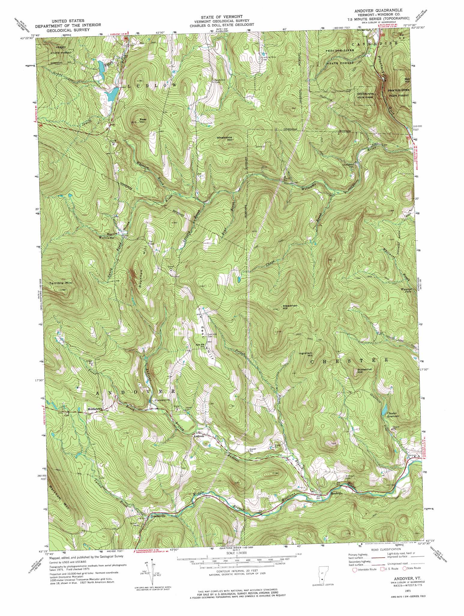
Andover Topo Map Vermont
To zoom in, hover over the map of Andover
USGS Topo Quad 43072c6 - 1:24,000 scale
| Topo Map Name: | Andover |
| USGS Topo Quad ID: | 43072c6 |
| Print Size: | ca. 21 1/4" wide x 27" high |
| Southeast Coordinates: | 43.25° N latitude / 72.625° W longitude |
| Map Center Coordinates: | 43.3125° N latitude / 72.6875° W longitude |
| U.S. State: | VT |
| Filename: | o43072c6.jpg |
| Download Map JPG Image: | Andover topo map 1:24,000 scale |
| Map Type: | Topographic |
| Topo Series: | 7.5´ |
| Map Scale: | 1:24,000 |
| Source of Map Images: | United States Geological Survey (USGS) |
| Alternate Map Versions: |
Andover VT 1971, updated 1975 Download PDF Buy paper map Andover VT 1971, updated 1984 Download PDF Buy paper map Andover VT 2012 Download PDF Buy paper map Andover VT 2015 Download PDF Buy paper map |
1:24,000 Topo Quads surrounding Andover
Rutland |
Killington Peak |
Plymouth |
Woodstock South |
Hartland |
Wallingford |
Mount Holly |
Ludlow |
Cavendish |
|
Danby |
Weston |
Andover |
Chester |
|
Peru |
Londonderry |
Saxtons River |
||
Stratton Mountain |
Jamaica |
Westminster West |
> Back to 43072a1 at 1:100,000 scale
> Back to 43072a1 at 1:250,000 scale
> Back to U.S. Topo Maps home
Andover topo map: Gazetteer
Andover: Airports
Holloway Airport elevation 514m 1686′Smith Airport elevation 461m 1512′
Andover: Dams
Jewell Brook Site Number 1 Dam elevation 494m 1620′Jewell Brook Site Number 2 Dam elevation 472m 1548′
Andover: Falls
Wymans Falls elevation 319m 1046′Andover: Forests
Chester Town Forest elevation 388m 1272′Proctor-Piper State Forest elevation 411m 1348′
Williams River State Forest elevation 460m 1509′
Andover: Populated Places
Andover elevation 346m 1135′Middletown elevation 481m 1578′
Reedville elevation 263m 862′
Simonsville elevation 354m 1161′
Andover: Reservoirs
Chester Reservoir elevation 338m 1108′Jewell Brook Site Number 1 Reservoir elevation 494m 1620′
Jewell Brook Site Number 2 Reservoir elevation 472m 1548′
Andover: Streams
Andover Branch elevation 264m 866′Bear Brook elevation 395m 1295′
Chase Brook elevation 314m 1030′
Grant Brook elevation 448m 1469′
Lovejoy Brook elevation 391m 1282′
Lyman Brook elevation 355m 1164′
Nancy Brook elevation 503m 1650′
Potash Brook elevation 285m 935′
Trout Brook elevation 376m 1233′
Wheaton Brook elevation 414m 1358′
Andover: Summits
Ball Hill elevation 570m 1870′Bear Hill elevation 664m 2178′
Boynton Hill elevation 661m 2168′
Butternut Hill elevation 511m 1676′
East Hill elevation 566m 1856′
Ingraham Hill elevation 591m 1938′
Steadman Hill elevation 705m 2312′
Terrible Mountain elevation 873m 2864′
Whetstone Hill elevation 608m 1994′
Andover: Valleys
Boynton Hollow elevation 424m 1391′Andover digital topo map on disk
Buy this Andover topo map showing relief, roads, GPS coordinates and other geographical features, as a high-resolution digital map file on DVD:
New York, Vermont, Connecticut & Western Massachusetts
Buy digital topo maps: New York, Vermont, Connecticut & Western Massachusetts