Sunapee Lake North Topo Map New Hampshire
To zoom in, hover over the map of Sunapee Lake North
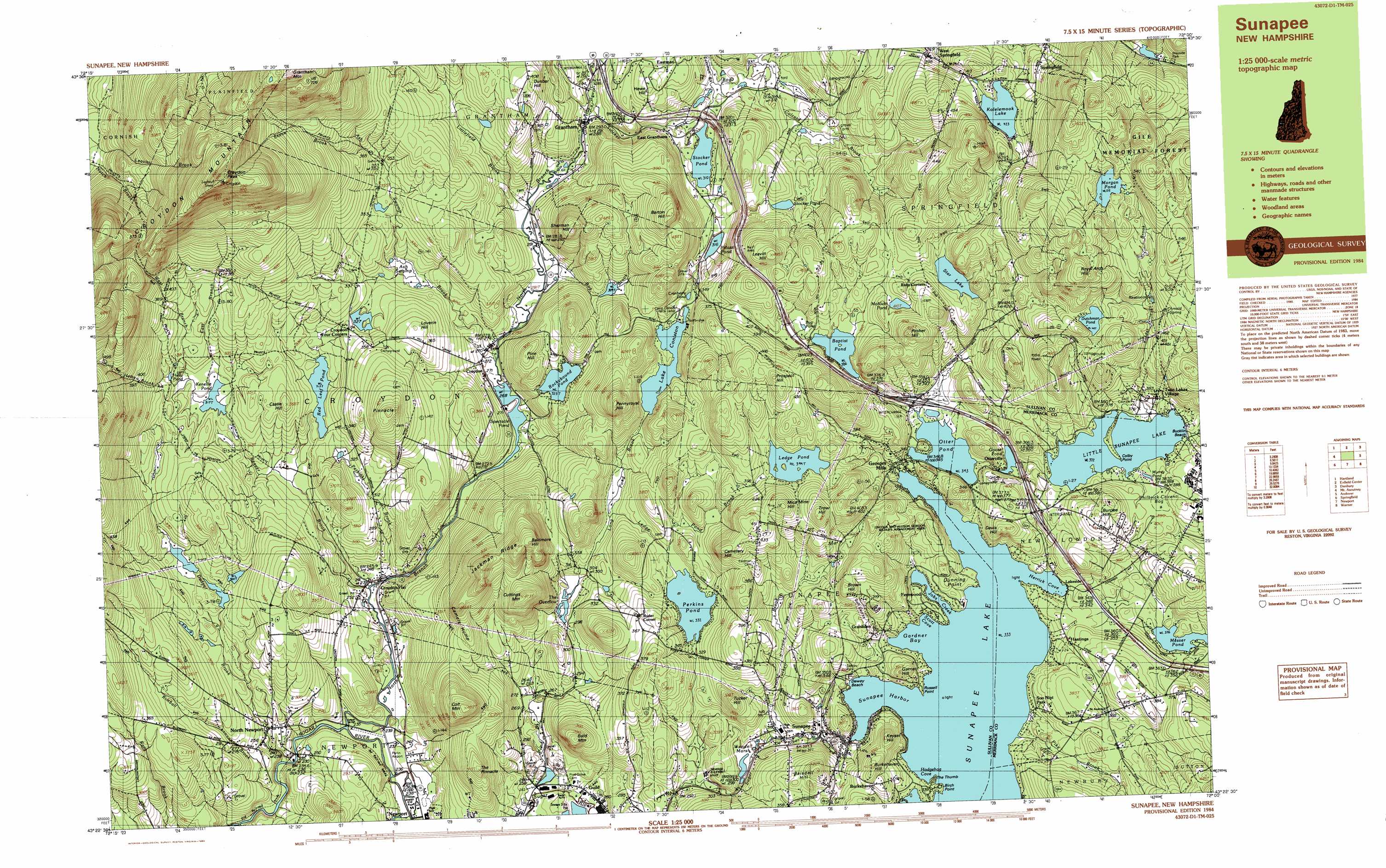
USGS Topo Quad 43072d1 - 1:25,000 scale
| Topo Map Name: | Sunapee Lake North |
| USGS Topo Quad ID: | 43072d1 |
| Print Size: | ca. 39" wide x 24" high |
| Southeast Coordinates: | 43.375° N latitude / 72° W longitude |
| Map Center Coordinates: | 43.4375° N latitude / 72.125° W longitude |
| U.S. State: | NH |
| Filename: | k43072d1.jpg |
| Download Map JPG Image: | Sunapee Lake North topo map 1:25,000 scale |
| Map Type: | Topographic |
| Topo Series: | 7.5´x15´ |
| Map Scale: | 1:25,000 |
| Source of Map Images: | United States Geological Survey (USGS) |
| Alternate Map Versions: |
Sunapee NH 1984, updated 1984 Download PDF Buy paper map Sunapee NH 1984, updated 1984 Download PDF Buy paper map |
1:24,000 Topo Quads surrounding Sunapee Lake North
Hanover |
Canaan |
Mount Cardigan |
Newfound Lake |
|
North Hartland |
Enfield Center |
Grafton |
Danbury |
|
Claremont North |
Sunapee Lake North |
New London |
Andover |
|
Claremont South |
Sunapee Lakes |
Bradford |
Warner |
|
Alstead |
Washington |
Hillsboro Upper Village |
Henniker |
> Back to 43072a1 at 1:100,000 scale
> Back to 43072a1 at 1:250,000 scale
> Back to U.S. Topo Maps home
Sunapee Lake North topo map: Gazetteer
Sunapee Lake North: Airports
Parlin Field elevation 235m 770′Sunapee Lake North: Bays
Gardner Bay elevation 333m 1092′Hedgehog Cove elevation 333m 1092′
Herrick Cove elevation 333m 1092′
Jobs Creek elevation 333m 1092′
Scott Cove elevation 333m 1092′
Sunapee Harbor elevation 333m 1092′
Sunapee Lake North: Beaches
Dewey Beach elevation 334m 1095′Sunapee Lake North: Bridges
Corbin Bridge elevation 231m 757′Sunapee Lake North: Capes
Birch Point elevation 337m 1105′Colby Point elevation 374m 1227′
Dunning Point elevation 336m 1102′
Russell Point elevation 336m 1102′
The Thumb elevation 336m 1102′
Sunapee Lake North: Crossings
Interchange 12 elevation 372m 1220′Interchange 12A elevation 347m 1138′
Interchange 13 elevation 308m 1010′
Sunapee Lake North: Dams
Bog Brook Dam elevation 315m 1033′Goose Pond Dam elevation 356m 1167′
Lake Sunapee Dam elevation 333m 1092′
Long Pond Brook Dam elevation 305m 1000′
Morgan Pond Dam elevation 515m 1689′
Otter Pond Dam elevation 346m 1135′
Red Leaf Pond Dam elevation 312m 1023′
Star Lake Dam elevation 396m 1299′
Sunapee Lake Town Dam elevation 339m 1112′
Wendall Marsh Dam elevation 310m 1017′
Sunapee Lake North: Forests
Gile Memorial Forest elevation 564m 1850′Springfield Town Forest elevation 480m 1574′
Sunapee Lake North: Islands
Loon Island elevation 333m 1092′Sunapee Lake North: Lakes
Baptist Pond elevation 387m 1269′Cranberry Pond elevation 336m 1102′
Dutchman Pond elevation 470m 1541′
Hetti Pond elevation 336m 1102′
Kolelemook Lake elevation 423m 1387′
Lake Coniston elevation 338m 1108′
Ledge Pond elevation 399m 1309′
Little Stocker Pond elevation 362m 1187′
Little Sunapee Lake elevation 372m 1220′
Lity Pond elevation 260m 853′
McAlvin Pond elevation 410m 1345′
Messer Pond elevation 336m 1102′
Murray Pond elevation 378m 1240′
Perkins Pond elevation 332m 1089′
Rockybound Pond elevation 323m 1059′
Spectacle Pond elevation 268m 879′
Stocker Pond elevation 310m 1017′
Sunapee Lake elevation 333m 1092′
The Overflow elevation 296m 971′
Sunapee Lake North: Parks
Dewey Park elevation 368m 1207′Gordon State Wildlife Management Area elevation 385m 1263′
Lincoln and Allison Gordon Wildlife Management Area elevation 344m 1128′
Wendell Marsh State Wildlife Management Area elevation 296m 971′
Sunapee Lake North: Populated Places
Burkehaven elevation 339m 1112′Croydon elevation 277m 908′
Croydon Flat elevation 242m 793′
East Grantham elevation 320m 1049′
Fernwood elevation 347m 1138′
Georges Mills elevation 347m 1138′
Granliden elevation 345m 1131′
Grantham elevation 288m 944′
Guild elevation 262m 859′
Hastings elevation 354m 1161′
Lakeside elevation 334m 1095′
Lower Village elevation 349m 1145′
North Newport elevation 251m 823′
Otterville elevation 361m 1184′
Ryder Corner elevation 369m 1210′
Springfield elevation 442m 1450′
Sunapee elevation 310m 1017′
Twin Lakes Village elevation 393m 1289′
West Springfield elevation 395m 1295′
Sunapee Lake North: Post Offices
Sunapee Post Office elevation 335m 1099′Sunapee Lake North: Reservoirs
Bog Brook Reservoir elevation 315m 1033′Goose Pond elevation 356m 1167′
Lake Sunapee elevation 340m 1115′
Morgan Pond elevation 515m 1689′
Otter Pond elevation 346m 1135′
Palazzi Pond elevation 324m 1062′
Red Leaf Pond elevation 312m 1023′
Star Lake elevation 396m 1299′
The Overflow Reservoir elevation 305m 1000′
Wendall Marsh elevation 310m 1017′
Sunapee Lake North: Ridges
Jackman Ridge elevation 500m 1640′Sunapee Lake North: Springs
Arnold Spring elevation 490m 1607′Sunapee Lake North: Streams
Ash Swamp Brook elevation 270m 885′Beaver Brook elevation 239m 784′
Bog Brook elevation 278m 912′
Bog Brook elevation 309m 1013′
Colcord Brook elevation 312m 1023′
Dodge Brook elevation 229m 751′
East Branch Beaver Brook elevation 317m 1040′
Eastman Brook elevation 308m 1010′
Hetty Brook elevation 323m 1059′
Kidder Brook elevation 372m 1220′
Kimball Brook elevation 223m 731′
Ledge Pond Brook elevation 308m 1010′
Littlefield Brook elevation 280m 918′
Long Pond Brook elevation 258m 846′
North Branch Sugar River elevation 232m 761′
Perkins Brook elevation 239m 784′
Sawyer Brook elevation 289m 948′
Stocker Brook elevation 289m 948′
Stone Brook elevation 353m 1158′
West Branch Beaver Brook elevation 317m 1040′
Sunapee Lake North: Summits
Baisdell Hill elevation 400m 1312′Bald Mountain elevation 413m 1354′
Baltimore Hill elevation 508m 1666′
Barton Hill elevation 481m 1578′
Brown Hill elevation 444m 1456′
Burkehaven Hill elevation 420m 1377′
Burpee Hill elevation 434m 1423′
Camels Hump elevation 465m 1525′
Castle Hill elevation 370m 1213′
Cemetery Hill elevation 454m 1489′
Coit Mountain elevation 484m 1587′
Croydon Mountain elevation 842m 2762′
Croydon Peak elevation 841m 2759′
Cuttings Mountain elevation 472m 1548′
Davis Hill elevation 409m 1341′
Dunbar Hill elevation 413m 1354′
Garnet Hill elevation 365m 1197′
Howe Hill elevation 375m 1230′
Hoyt Hill elevation 554m 1817′
Keyser Hill elevation 418m 1371′
Leavitt Hill elevation 484m 1587′
Loverin Hill elevation 370m 1213′
Mica Mine Hill elevation 478m 1568′
Pennyroyal Hill elevation 481m 1578′
Pine Hill elevation 374m 1227′
Pinnacle elevation 453m 1486′
Pitcher Hill elevation 496m 1627′
Prospect Hill elevation 476m 1561′
Royal Arch Hill elevation 593m 1945′
Sherman Hill elevation 443m 1453′
The Pinnacle elevation 411m 1348′
Trow Hill elevation 483m 1584′
Tucker Hill elevation 394m 1292′
Sunapee Lake North: Swamps
Philbrick Cricenti Bog elevation 393m 1289′Sunapee Lake North digital topo map on disk
Buy this Sunapee Lake North topo map showing relief, roads, GPS coordinates and other geographical features, as a high-resolution digital map file on DVD:
New York, Vermont, Connecticut & Western Massachusetts
Buy digital topo maps: New York, Vermont, Connecticut & Western Massachusetts