Wallingford Topo Map Vermont
To zoom in, hover over the map of Wallingford
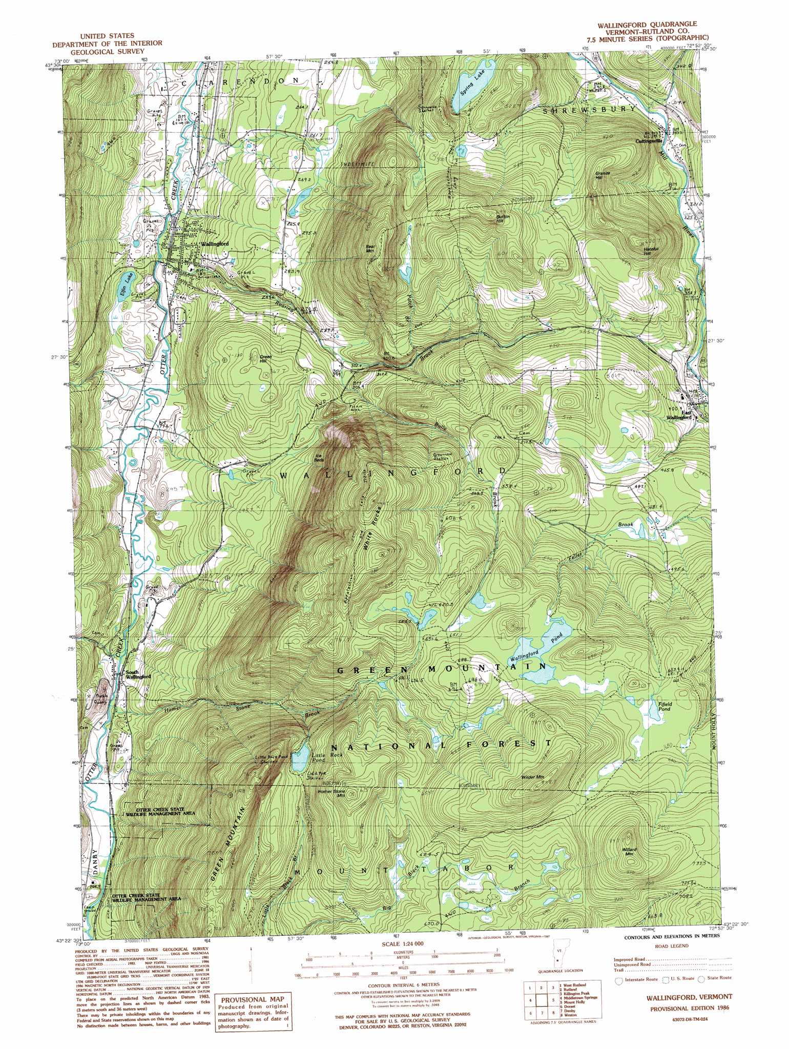
USGS Topo Quad 43072d8 - 1:24,000 scale
| Topo Map Name: | Wallingford |
| USGS Topo Quad ID: | 43072d8 |
| Print Size: | ca. 21 1/4" wide x 27" high |
| Southeast Coordinates: | 43.375° N latitude / 72.875° W longitude |
| Map Center Coordinates: | 43.4375° N latitude / 72.9375° W longitude |
| U.S. State: | VT |
| Filename: | o43072d8.jpg |
| Download Map JPG Image: | Wallingford topo map 1:24,000 scale |
| Map Type: | Topographic |
| Topo Series: | 7.5´ |
| Map Scale: | 1:24,000 |
| Source of Map Images: | United States Geological Survey (USGS) |
| Alternate Map Versions: |
Wallingford VT 1986, updated 1987 Download PDF Buy paper map Wallingford VT 1997, updated 2000 Download PDF Buy paper map Wallingford VT 2012 Download PDF Buy paper map Wallingford VT 2015 Download PDF Buy paper map |
| FStopo: | US Forest Service topo Wallingford is available: Download FStopo PDF Download FStopo TIF |
1:24,000 Topo Quads surrounding Wallingford
Bomoseen |
Proctor |
Chittenden |
Pico Peak |
Delectable Mountain |
Poultney |
West Rutland |
Rutland |
Killington Peak |
Plymouth |
Wells |
Middletown Springs |
Wallingford |
Mount Holly |
Ludlow |
Pawlet |
Dorset |
Danby |
Weston |
Andover |
West Rupert |
Manchester |
Peru |
Londonderry |
> Back to 43072a1 at 1:100,000 scale
> Back to 43072a1 at 1:250,000 scale
> Back to U.S. Topo Maps home
Wallingford topo map: Gazetteer
Wallingford: Forests
Green Mountain National Forest elevation 669m 2194′Wallingford Municipal Forest elevation 186m 610′
Wallingford Municipal Forest elevation 489m 1604′
Wallingford: Glaciers
Ice Beds elevation 393m 1289′Wallingford: Lakes
Elfin Lake elevation 190m 623′Fifield Pond elevation 675m 2214′
Little Rock Pond elevation 571m 1873′
Spring Lake elevation 452m 1482′
Wallingford Pond elevation 662m 2171′
Wallingford: Parks
Otter Creek State Wildlife Management Area elevation 299m 980′Wallingford Main Street Historic District elevation 186m 610′
White Rocks National Recreation Area elevation 635m 2083′
Wallingford: Populated Places
Cuttingsville elevation 309m 1013′East Wallingford elevation 364m 1194′
South Wallingford elevation 195m 639′
Timber Hill Estates elevation 187m 613′
Wallingford elevation 185m 606′
Wallingford: Post Offices
Cuttingsville Post Office elevation 305m 1000′East Wallingford Post Office elevation 391m 1282′
Wallingford Post Office elevation 182m 597′
Wallingford: Streams
Baker Brook elevation 195m 639′Bully Brook elevation 297m 974′
Feller Brook elevation 476m 1561′
Freeman Brook elevation 331m 1085′
Homer Stone Brook elevation 192m 629′
Patch Brook elevation 349m 1145′
Roaring Brook elevation 180m 590′
Wallingford: Summits
Bear Mountain elevation 680m 2230′Button Hill elevation 645m 2116′
Granite Hill elevation 528m 1732′
Green Hill elevation 363m 1190′
Green Mountain elevation 753m 2470′
Hateful Hill elevation 576m 1889′
Homer Stone Mountain elevation 761m 2496′
White Rocks elevation 811m 2660′
Wilder Mountain elevation 844m 2769′
Willard Mountain elevation 836m 2742′
Wallingford: Trails
Green Mountain Trail elevation 683m 2240′Homer Stone Trail elevation 469m 1538′
Keewaydin Trail elevation 529m 1735′
Wallingford digital topo map on disk
Buy this Wallingford topo map showing relief, roads, GPS coordinates and other geographical features, as a high-resolution digital map file on DVD:
New York, Vermont, Connecticut & Western Massachusetts
Buy digital topo maps: New York, Vermont, Connecticut & Western Massachusetts