North Hartland Topo Map New Hampshire
To zoom in, hover over the map of North Hartland
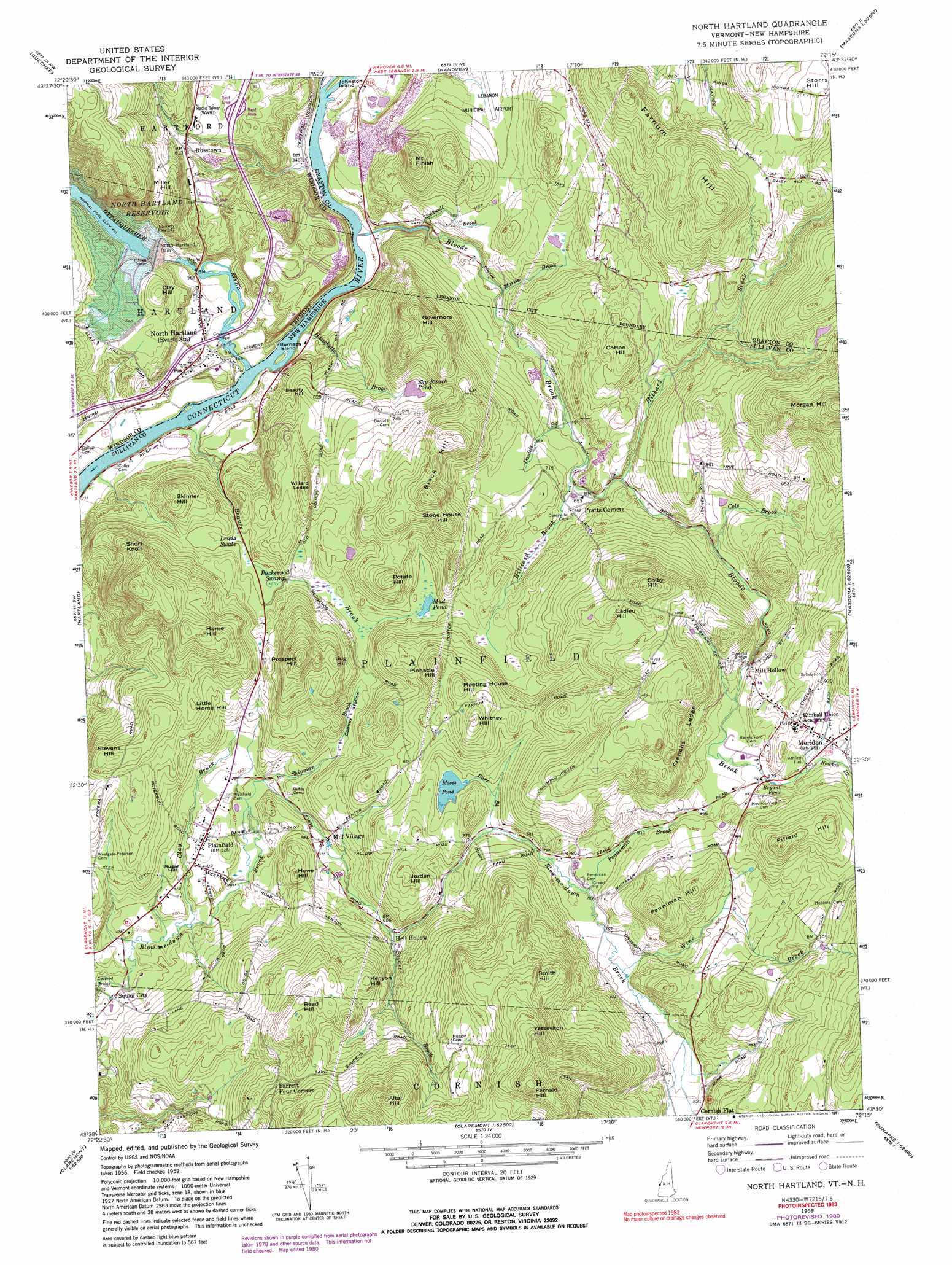
USGS Topo Quad 43072e3 - 1:24,000 scale
| Topo Map Name: | North Hartland |
| USGS Topo Quad ID: | 43072e3 |
| Print Size: | ca. 21 1/4" wide x 27" high |
| Southeast Coordinates: | 43.5° N latitude / 72.25° W longitude |
| Map Center Coordinates: | 43.5625° N latitude / 72.3125° W longitude |
| U.S. States: | NH, VT |
| Filename: | o43072e3.jpg |
| Download Map JPG Image: | North Hartland topo map 1:24,000 scale |
| Map Type: | Topographic |
| Topo Series: | 7.5´ |
| Map Scale: | 1:24,000 |
| Source of Map Images: | United States Geological Survey (USGS) |
| Alternate Map Versions: |
North Hartland VT 1959, updated 1961 Download PDF Buy paper map North Hartland VT 1959, updated 1965 Download PDF Buy paper map North Hartland VT 1959, updated 1981 Download PDF Buy paper map North Hartland VT 1959, updated 1991 Download PDF Buy paper map North Hartland VT 1998, updated 1998 Download PDF Buy paper map North Hartland VT 2012 Download PDF Buy paper map North Hartland VT 2015 Download PDF Buy paper map |
1:24,000 Topo Quads surrounding North Hartland
South Royalton |
Sharon |
South Strafford |
Lyme |
Smarts Mountain |
Woodstock North |
Quechee |
Hanover |
Canaan |
|
Woodstock South |
Hartland |
North Hartland |
Enfield Center |
|
Cavendish |
Claremont North |
Sunapee Lake North |
||
Chester |
Claremont South |
Sunapee Lakes |
> Back to 43072e1 at 1:100,000 scale
> Back to 43072a1 at 1:250,000 scale
> Back to U.S. Topo Maps home
North Hartland topo map: Gazetteer
North Hartland: Airports
Air-Wood Heliport elevation 165m 541′North Hartland: Benches
Frenchs Ledge elevation 312m 1023′Willard Ledge elevation 243m 797′
North Hartland: Bridges
Blow-Me-Down Bridge elevation 128m 419′Meriden Bridge elevation 247m 810′
Ottauquechee River Bridge elevation 96m 314′
Willard Covered Bridge elevation 96m 314′
North Hartland: Dams
North Hartland Dam elevation 172m 564′Storrs Pond Dam elevation 312m 1023′
North Hartland: Islands
Burnaps Island elevation 96m 314′Johnston Island elevation 99m 324′
North Hartland: Lakes
Bryant Pond elevation 267m 875′Cranberry Pond elevation 103m 337′
Moses Pond elevation 238m 780′
Mud Pond elevation 210m 688′
Sky Ranch Pond elevation 209m 685′
North Hartland: Parks
North Hartland Dam Recreation Area elevation 136m 446′North Hartland: Populated Places
Hell Hollow elevation 206m 675′Meriden elevation 283m 928′
Mill Hollow elevation 258m 846′
Mill Village elevation 166m 544′
North Hartland elevation 111m 364′
Plainfield elevation 159m 521′
Russtown elevation 182m 597′
Squag City elevation 142m 465′
North Hartland: Reservoirs
North Hartland Reservoir elevation 169m 554′Storrs Pond elevation 312m 1023′
North Hartland: Ridges
Black Hill elevation 313m 1026′Farnum Hill elevation 361m 1184′
Fifield Hill elevation 366m 1200′
Governors Hill elevation 316m 1036′
Penniman Hill elevation 313m 1026′
North Hartland: Streams
Beaver Brook elevation 100m 328′Bloods Brook elevation 100m 328′
Bryant Brook elevation 200m 656′
Burr Brook elevation 233m 764′
Clay Brook elevation 137m 449′
Cole Brook elevation 219m 718′
Daniels Brook elevation 176m 577′
Hanchetts Brook elevation 97m 318′
Hibbard Brook elevation 202m 662′
Hilliard Brook elevation 190m 623′
Martin Brook elevation 157m 515′
Newton Brook elevation 275m 902′
Ottauquechee River elevation 96m 314′
Penniman Brook elevation 237m 777′
Shipman Brook elevation 151m 495′
Stockwell Brook elevation 122m 400′
Wine Brook elevation 240m 787′
North Hartland: Summits
Altai Hill elevation 424m 1391′Beauty Hill elevation 198m 649′
Clay Hill elevation 210m 688′
Colby Hill elevation 400m 1312′
Cotton Hill elevation 291m 954′
Fernald Hill elevation 490m 1607′
Home Hill elevation 324m 1062′
Howe Hill elevation 225m 738′
Jordan Hill elevation 282m 925′
Jug Hill elevation 293m 961′
Kenyon Hill elevation 306m 1003′
Ladieu Hill elevation 352m 1154′
Little Home Hill elevation 244m 800′
Meeting House Hill elevation 323m 1059′
Miller Hill elevation 276m 905′
Morgan Hill elevation 436m 1430′
Mount Finish elevation 275m 902′
Pinnacle Hill elevation 317m 1040′
Potato Hill elevation 288m 944′
Prospect Hill elevation 344m 1128′
Read Hill elevation 341m 1118′
Short Knoll elevation 276m 905′
Skinner Hill elevation 243m 797′
Smith Hill elevation 388m 1272′
Stevens Hill elevation 262m 859′
Stone House Hill elevation 320m 1049′
Storrs Hill elevation 349m 1145′
Sugar Hill elevation 171m 561′
Whitney Hill elevation 339m 1112′
Yatsevitch Hill elevation 457m 1499′
North Hartland: Swamps
Puckerpod Swamp elevation 180m 590′North Hartland: Valleys
Cooney Hollow elevation 167m 547′Frog Hollow elevation 275m 902′
Lewis Swale elevation 116m 380′
North Hartland digital topo map on disk
Buy this North Hartland topo map showing relief, roads, GPS coordinates and other geographical features, as a high-resolution digital map file on DVD:
New York, Vermont, Connecticut & Western Massachusetts
Buy digital topo maps: New York, Vermont, Connecticut & Western Massachusetts