Hartland Topo Map Vermont
To zoom in, hover over the map of Hartland
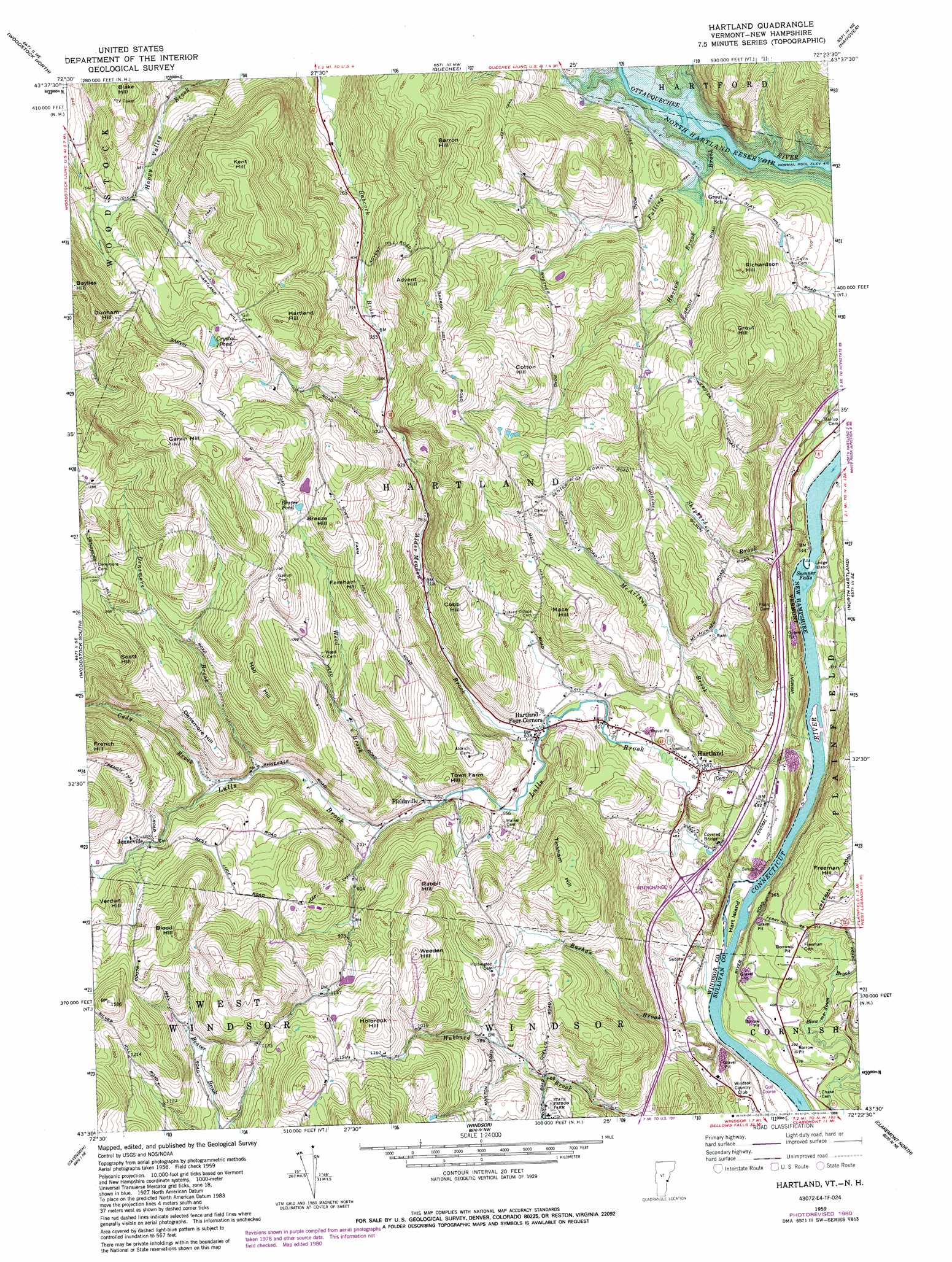
USGS Topo Quad 43072e4 - 1:24,000 scale
| Topo Map Name: | Hartland |
| USGS Topo Quad ID: | 43072e4 |
| Print Size: | ca. 21 1/4" wide x 27" high |
| Southeast Coordinates: | 43.5° N latitude / 72.375° W longitude |
| Map Center Coordinates: | 43.5625° N latitude / 72.4375° W longitude |
| U.S. States: | VT, NH |
| Filename: | o43072e4.jpg |
| Download Map JPG Image: | Hartland topo map 1:24,000 scale |
| Map Type: | Topographic |
| Topo Series: | 7.5´ |
| Map Scale: | 1:24,000 |
| Source of Map Images: | United States Geological Survey (USGS) |
| Alternate Map Versions: |
Hartland VT 1959, updated 1961 Download PDF Buy paper map Hartland VT 1959, updated 1971 Download PDF Buy paper map Hartland VT 1959, updated 1981 Download PDF Buy paper map Hartland VT 1959, updated 1988 Download PDF Buy paper map Hartland VT 1998, updated 1999 Download PDF Buy paper map Hartland VT 2012 Download PDF Buy paper map Hartland VT 2015 Download PDF Buy paper map |
1:24,000 Topo Quads surrounding Hartland
Bethel |
South Royalton |
Sharon |
South Strafford |
Lyme |
Delectable Mountain |
Woodstock North |
Quechee |
Hanover |
|
Plymouth |
Woodstock South |
Hartland |
North Hartland |
|
Ludlow |
Cavendish |
Claremont North |
||
Andover |
Chester |
Claremont South |
> Back to 43072e1 at 1:100,000 scale
> Back to 43072a1 at 1:250,000 scale
> Back to U.S. Topo Maps home
Hartland topo map: Gazetteer
Hartland: Bridges
Martins Mill Covered Bridge elevation 115m 377′Hartland: Crossings
Interchange 9 elevation 134m 439′Hartland: Dams
Bronson Dam elevation 310m 1017′Hartland: Falls
Sumner Falls elevation 94m 308′Sumner Falls elevation 94m 308′
Hartland: Islands
Hart Island elevation 99m 324′Ledge Island elevation 95m 311′
Hartland: Lakes
Beaver Pond elevation 358m 1174′Crystal Pond elevation 413m 1354′
Hartland: Populated Places
Fieldsville elevation 210m 688′Hartland elevation 182m 597′
Hartland Four Corners elevation 191m 626′
Jenneville elevation 303m 994′
Hartland: Streams
Alder Meadow Brook elevation 191m 626′Bashan Brook elevation 94m 308′
Cady Brook elevation 242m 793′
Densmore Brook elevation 238m 780′
Fulling Brook elevation 125m 410′
Harlow Brook elevation 170m 557′
Lulls Brook elevation 95m 311′
McArthur Brook elevation 94m 308′
Shepherd Brook elevation 94m 308′
Weed Brook elevation 208m 682′
Hartland: Summits
Advent Hill elevation 413m 1354′Barron Hill elevation 423m 1387′
Baylies Hill elevation 506m 1660′
Blood Hill elevation 468m 1535′
Breeze Hill elevation 403m 1322′
Cobb Hill elevation 296m 971′
Cotton Hill elevation 367m 1204′
Densmore Hill elevation 367m 1204′
Dunham Hill elevation 501m 1643′
Fareham Hill elevation 377m 1236′
Freeman Hill elevation 216m 708′
French Hill elevation 483m 1584′
Garvin Hill elevation 551m 1807′
Grout Hill elevation 348m 1141′
Hall Hill elevation 421m 1381′
Hartland Hill elevation 458m 1502′
Holbrook Hill elevation 407m 1335′
Kent Hill elevation 481m 1578′
Mace Hill elevation 335m 1099′
Rabbit Hill elevation 366m 1200′
Richardson Hill elevation 317m 1040′
Scott Hill elevation 472m 1548′
Tinkham Hill elevation 355m 1164′
Town Farm Hill elevation 274m 898′
Verdun Hill elevation 391m 1282′
Weeden Hill elevation 403m 1322′
Hartland digital topo map on disk
Buy this Hartland topo map showing relief, roads, GPS coordinates and other geographical features, as a high-resolution digital map file on DVD:
New York, Vermont, Connecticut & Western Massachusetts
Buy digital topo maps: New York, Vermont, Connecticut & Western Massachusetts