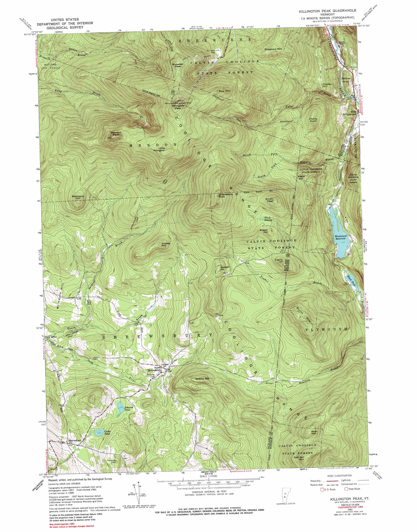
Killington Peak Topo Map Vermont
To zoom in, hover over the map of Killington Peak
USGS Topo Quad 43072e7 - 1:24,000 scale
| Topo Map Name: | Killington Peak |
| USGS Topo Quad ID: | 43072e7 |
| Print Size: | ca. 21 1/4" wide x 27" high |
| Southeast Coordinates: | 43.5° N latitude / 72.75° W longitude |
| Map Center Coordinates: | 43.5625° N latitude / 72.8125° W longitude |
| U.S. State: | VT |
| Filename: | o43072e7.jpg |
| Download Map JPG Image: | Killington Peak topo map 1:24,000 scale |
| Map Type: | Topographic |
| Topo Series: | 7.5´ |
| Map Scale: | 1:24,000 |
| Source of Map Images: | United States Geological Survey (USGS) |
| Alternate Map Versions: |
Killington Peak VT 1961, updated 1964 Download PDF Buy paper map Killington Peak VT 1961, updated 1988 Download PDF Buy paper map Killington Peak VT 1961, updated 1988 Download PDF Buy paper map Killington Peak VT 1997, updated 2000 Download PDF Buy paper map Killington Peak VT 2012 Download PDF Buy paper map Killington Peak VT 2015 Download PDF Buy paper map |
| FStopo: | US Forest Service topo Killington Peak is available: Download FStopo PDF Download FStopo TIF |
1:24,000 Topo Quads surrounding Killington Peak
Brandon |
Mount Carmel |
Rochester |
Bethel |
South Royalton |
Proctor |
Chittenden |
Pico Peak |
Delectable Mountain |
Woodstock North |
West Rutland |
Rutland |
Killington Peak |
Plymouth |
Woodstock South |
Middletown Springs |
Wallingford |
Mount Holly |
Ludlow |
Cavendish |
Dorset |
Danby |
Weston |
Andover |
Chester |
> Back to 43072e1 at 1:100,000 scale
> Back to 43072a1 at 1:250,000 scale
> Back to U.S. Topo Maps home
Killington Peak topo map: Gazetteer
Killington Peak: Areas
Killington Ski Area elevation 788m 2585′Killington Peak: Dams
Black Pond Dam elevation 406m 1332′Woodward Reservoir Dam elevation 409m 1341′
Killington Peak: Forests
Calvin Coolidge State Forest elevation 872m 2860′Killington Peak: Lakes
Cooks Pond elevation 533m 1748′Johnson Pond elevation 533m 1748′
Killington Peak: Parks
Plymsbury Wildlife Management Area elevation 652m 2139′Killington Peak: Populated Places
North Shrewsbury elevation 534m 1751′Shrewsbury elevation 503m 1650′
South Sherburne elevation 342m 1122′
Killington Peak: Ranges
Coolidge Range elevation 965m 3166′Killington Peak: Reservoirs
Black Pond elevation 406m 1332′Woodward Reservoir elevation 409m 1341′
Killington Peak: Streams
Falls Brook elevation 344m 1128′Gould Brook elevation 414m 1358′
Madden Brook elevation 351m 1151′
North Fork Madden Brook elevation 638m 2093′
Sargent Brook elevation 450m 1476′
South Fork Madden Brook elevation 642m 2106′
Tinker Brook elevation 405m 1328′
Killington Peak: Summits
Allens Hill elevation 705m 2312′Bear Mountain elevation 941m 3087′
Bear Mountain elevation 1159m 3802′
Bissell Hill elevation 849m 2785′
Burnt Mountain elevation 853m 2798′
Cherry Knoll elevation 678m 2224′
Comtois Hill elevation 609m 1998′
Hadley Hill elevation 550m 1804′
Ingalls Hill elevation 802m 2631′
Jockey Hill elevation 805m 2641′
Killington Peak elevation 1288m 4225′
Little Killington elevation 1194m 3917′
Mendon Peak elevation 1170m 3838′
Robinson Hill elevation 837m 2746′
Russell Hill elevation 771m 2529′
Saddle Mountain elevation 756m 2480′
Salt Ash Mountain elevation 1002m 3287′
Shagback Mountain elevation 819m 2687′
Shrewsbury Peak elevation 1122m 3681′
Smith Peak elevation 975m 3198′
Snowden Peak elevation 1094m 3589′
Spruce Knoll elevation 397m 1302′
Wilmouth Hill elevation 541m 1774′
Killington Peak: Swamps
Black Swamp elevation 826m 2709′Killington Peak: Trails
Bucklin Trail elevation 675m 2214′Juggernaut Trail elevation 802m 2631′
Killington Peak digital topo map on disk
Buy this Killington Peak topo map showing relief, roads, GPS coordinates and other geographical features, as a high-resolution digital map file on DVD:
New York, Vermont, Connecticut & Western Massachusetts
Buy digital topo maps: New York, Vermont, Connecticut & Western Massachusetts