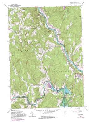
Quechee Topo Map Vermont
To zoom in, hover over the map of Quechee
USGS Topo Quad 43072f4 - 1:24,000 scale
| Topo Map Name: | Quechee |
| USGS Topo Quad ID: | 43072f4 |
| Print Size: | ca. 21 1/4" wide x 27" high |
| Southeast Coordinates: | 43.625° N latitude / 72.375° W longitude |
| Map Center Coordinates: | 43.6875° N latitude / 72.4375° W longitude |
| U.S. State: | VT |
| Filename: | o43072f4.jpg |
| Download Map JPG Image: | Quechee topo map 1:24,000 scale |
| Map Type: | Topographic |
| Topo Series: | 7.5´ |
| Map Scale: | 1:24,000 |
| Source of Map Images: | United States Geological Survey (USGS) |
| Alternate Map Versions: |
Quechee VT 1959, updated 1961 Download PDF Buy paper map Quechee VT 1959, updated 1971 Download PDF Buy paper map Quechee VT 1959, updated 1981 Download PDF Buy paper map Quechee VT 1959, updated 1988 Download PDF Buy paper map Quechee VT 1959, updated 1988 Download PDF Buy paper map Quechee VT 1996, updated 2000 Download PDF Buy paper map Quechee VT 2012 Download PDF Buy paper map Quechee VT 2015 Download PDF Buy paper map |
| FStopo: | US Forest Service topo Quechee is available: Download FStopo PDF Download FStopo TIF |
1:24,000 Topo Quads surrounding Quechee
> Back to 43072e1 at 1:100,000 scale
> Back to 43072a1 at 1:250,000 scale
> Back to U.S. Topo Maps home
Quechee topo map: Gazetteer
Quechee: Airports
R G Newsome Heliport elevation 193m 633′Quechee: Bridges
Quechee Covered Bridge elevation 162m 531′Quechee Gorge Bridge elevation 154m 505′
Taftsville Covered Bridge elevation 187m 613′
Quechee: Crossings
Interchange 1 elevation 220m 721′Quechee: Dams
Deweys Mills Dam elevation 155m 508′Emery Mills Dam elevation 173m 567′
Lake Mitchell Dam elevation 259m 849′
Lake Pinneo Dam elevation 174m 570′
Taftsville Dam elevation 192m 629′
Quechee: Forests
Norwich Town Forest elevation 287m 941′Pomfret Town Forest elevation 386m 1266′
Quechee: Populated Places
Centertown elevation 252m 826′Centerville elevation 120m 393′
Deweys Mills elevation 168m 551′
Hewitts Corners elevation 325m 1066′
Millbrook elevation 203m 666′
North Pomfret elevation 269m 882′
Quechee elevation 170m 557′
Taftsville elevation 196m 643′
West Hartford elevation 114m 374′
Quechee: Reservoirs
Deweys Pond elevation 148m 485′Lake Pinneo elevation 174m 570′
Lake Pinneo elevation 174m 570′
Mitchell Pond elevation 259m 849′
Quechee: Streams
Babcock Brook elevation 185m 606′Dimick Brook elevation 112m 367′
Happy Valley Brook elevation 192m 629′
Jericho Brook elevation 112m 367′
Mill Brook elevation 118m 387′
Mitchell Brook elevation 117m 383′
Podunk Brook elevation 113m 370′
Quechee Gorge elevation 131m 429′
Tigertown Brook elevation 114m 374′
Whitman Brook elevation 174m 570′
Quechee: Summits
Blake Hill elevation 433m 1420′Bunker Hill elevation 464m 1522′
Howe Hill elevation 482m 1581′
Savage Hill elevation 389m 1276′
Seaver Hill elevation 588m 1929′
Thistle Hill elevation 598m 1961′
Quechee digital topo map on disk
Buy this Quechee topo map showing relief, roads, GPS coordinates and other geographical features, as a high-resolution digital map file on DVD:
New York, Vermont, Connecticut & Western Massachusetts
Buy digital topo maps: New York, Vermont, Connecticut & Western Massachusetts


