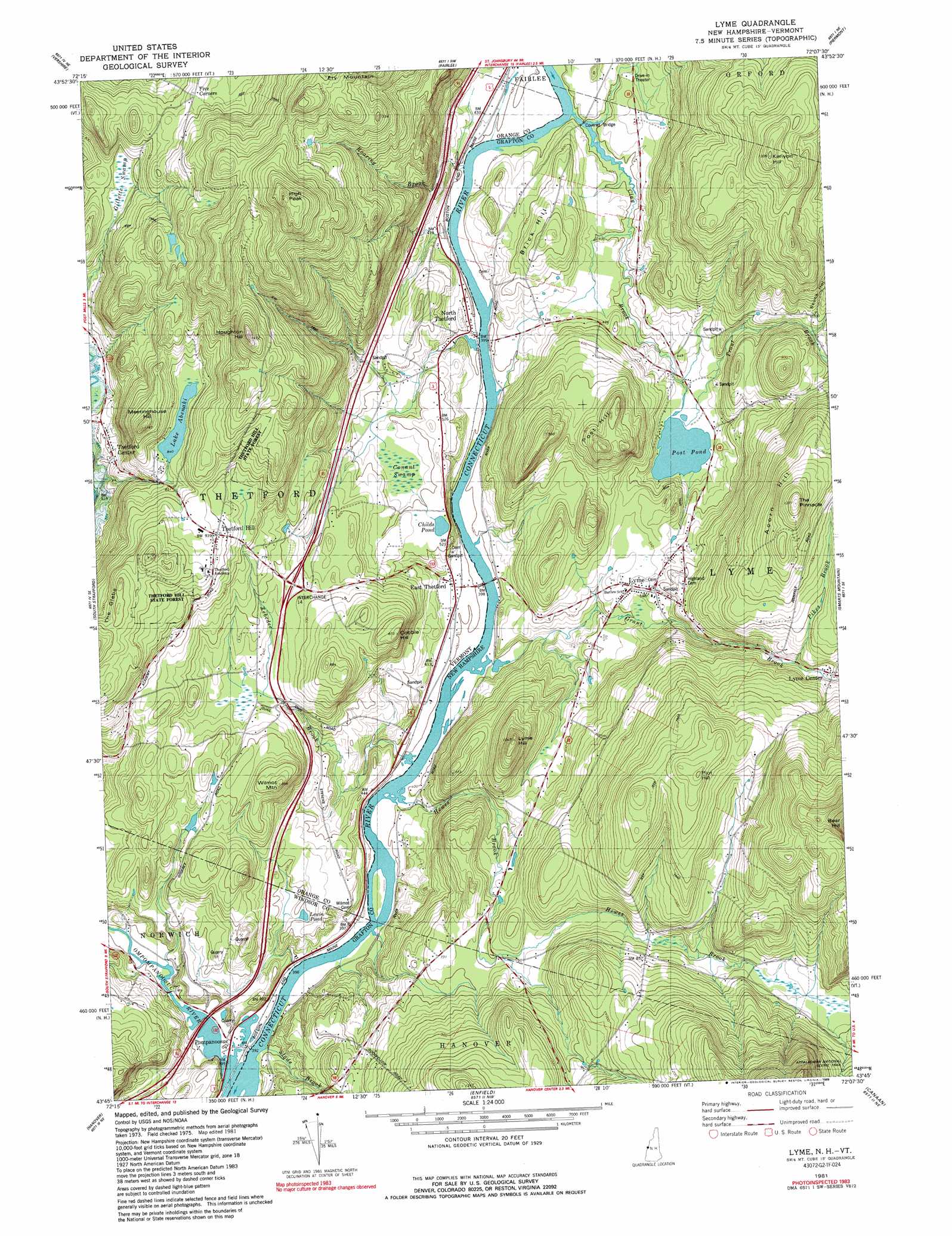
Lyme Topo Map New Hampshire
To zoom in, hover over the map of Lyme
USGS Topo Quad 43072g2 - 1:24,000 scale
| Topo Map Name: | Lyme |
| USGS Topo Quad ID: | 43072g2 |
| Print Size: | ca. 21 1/4" wide x 27" high |
| Southeast Coordinates: | 43.75° N latitude / 72.125° W longitude |
| Map Center Coordinates: | 43.8125° N latitude / 72.1875° W longitude |
| U.S. States: | NH, VT |
| Filename: | o43072g2.jpg |
| Download Map JPG Image: | Lyme topo map 1:24,000 scale |
| Map Type: | Topographic |
| Topo Series: | 7.5´ |
| Map Scale: | 1:24,000 |
| Source of Map Images: | United States Geological Survey (USGS) |
| Alternate Map Versions: |
Lyme NH 1981, updated 1981 Download PDF Buy paper map Lyme NH 1981, updated 1989 Download PDF Buy paper map Lyme NH 1981, updated 1989 Download PDF Buy paper map Lyme NH 1996, updated 2001 Download PDF Buy paper map Lyme NH 2012 Download PDF Buy paper map Lyme NH 2015 Download PDF Buy paper map |
| FStopo: | US Forest Service topo Lyme is available: Download FStopo PDF Download FStopo TIF |
1:24,000 Topo Quads surrounding Lyme
Washington |
West Topsham |
East Corinth |
Newbury |
East Haverhill |
Chelsea |
Vershire |
Fairlee |
Piermont |
Warren |
Sharon |
South Strafford |
Lyme |
Smarts Mountain |
Wentworth |
Quechee |
Hanover |
Canaan |
Mount Cardigan |
|
Hartland |
North Hartland |
Enfield Center |
Grafton |
> Back to 43072e1 at 1:100,000 scale
> Back to 43072a1 at 1:250,000 scale
> Back to U.S. Topo Maps home
Lyme topo map: Gazetteer
Lyme: Bridges
Edgell Bridge elevation 120m 393′Lyme: Crossings
Interchange 14 elevation 206m 675′Lyme: Dams
Lake Abenaki Dam elevation 257m 843′Lyme: Forests
Thetford Hill State Forest elevation 292m 958′Thetford Hill State Forest elevation 165m 541′
Thetford Municipal Forest elevation 291m 954′
Lyme: Lakes
Childs Pond elevation 152m 498′Lake Abenaki elevation 256m 839′
Lewin Pond elevation 150m 492′
Post Pond elevation 129m 423′
Lyme: Parks
Lyme Common Historic District elevation 162m 531′Thetford Hill Historic District elevation 283m 928′
Wilder Management Area elevation 120m 393′
Lyme: Populated Places
East Thetford elevation 125m 410′Lyme elevation 166m 544′
North Thetford elevation 124m 406′
Pompanoosuc elevation 118m 387′
Thetford Center elevation 186m 610′
Thetford Hill elevation 281m 921′
Lyme: Post Offices
Lyme Post Office elevation 169m 554′Thetford Post Office elevation 159m 521′
Lyme: Reservoirs
Lake Abenaki elevation 257m 843′Lyme: Ridges
Brick Hill elevation 180m 590′The Glebe elevation 337m 1105′
Lyme: Streams
Clay Brook elevation 120m 393′Grant Brook elevation 117m 383′
Gunn Brook elevation 144m 472′
Hewes Brook elevation 209m 685′
Hewes Brook elevation 117m 383′
Ompompanoosuc River elevation 116m 380′
Roaring Brook elevation 120m 393′
Trout Brook elevation 126m 413′
Whipple Brook elevation 217m 711′
Zebedee Brook elevation 117m 383′
Lyme: Summits
Acorn Hill elevation 407m 1335′Cobble Hill elevation 254m 833′
High Peak elevation 506m 1660′
Houghton Hill elevation 448m 1469′
Kenyon Hill elevation 382m 1253′
Lyme Hill elevation 317m 1040′
Meetinghouse Hill elevation 349m 1145′
Plot Hill elevation 397m 1302′
Post Hill elevation 299m 980′
Wilmot Mountain elevation 269m 882′
Lyme: Swamps
Conant Swamp elevation 145m 475′Gillette Swamp elevation 237m 777′
Lyme: Trails
Dartmouth Outing Club Trail elevation 317m 1040′Lyme: Valleys
Skunk Hollow elevation 215m 705′Lyme digital topo map on disk
Buy this Lyme topo map showing relief, roads, GPS coordinates and other geographical features, as a high-resolution digital map file on DVD:
New York, Vermont, Connecticut & Western Massachusetts
Buy digital topo maps: New York, Vermont, Connecticut & Western Massachusetts