Rochester Topo Map Vermont
To zoom in, hover over the map of Rochester
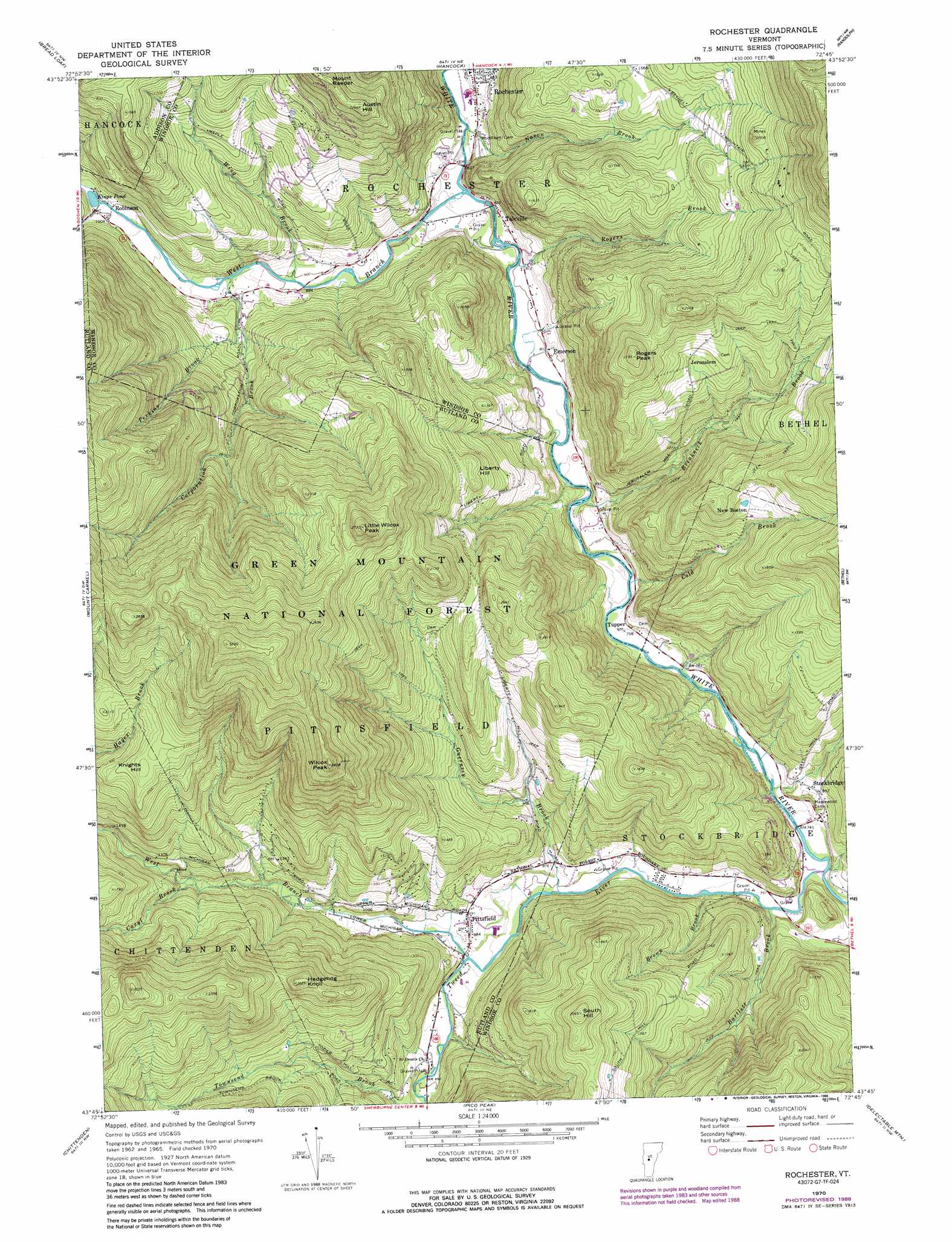
USGS Topo Quad 43072g7 - 1:24,000 scale
| Topo Map Name: | Rochester |
| USGS Topo Quad ID: | 43072g7 |
| Print Size: | ca. 21 1/4" wide x 27" high |
| Southeast Coordinates: | 43.75° N latitude / 72.75° W longitude |
| Map Center Coordinates: | 43.8125° N latitude / 72.8125° W longitude |
| U.S. State: | VT |
| Filename: | o43072g7.jpg |
| Download Map JPG Image: | Rochester topo map 1:24,000 scale |
| Map Type: | Topographic |
| Topo Series: | 7.5´ |
| Map Scale: | 1:24,000 |
| Source of Map Images: | United States Geological Survey (USGS) |
| Alternate Map Versions: |
Rochester VT 1970, updated 1972 Download PDF Buy paper map Rochester VT 1970, updated 1977 Download PDF Buy paper map Rochester VT 1970, updated 1988 Download PDF Buy paper map Rochester VT 1997, updated 2000 Download PDF Buy paper map Rochester VT 2012 Download PDF Buy paper map Rochester VT 2015 Download PDF Buy paper map |
| FStopo: | US Forest Service topo Rochester is available: Download FStopo PDF Download FStopo TIF |
1:24,000 Topo Quads surrounding Rochester
South Mountain |
Lincoln |
Warren |
Roxbury |
Brookfield |
East Middlebury |
Bread Loaf |
Hancock |
Randolph |
Randolph Center |
Brandon |
Mount Carmel |
Rochester |
Bethel |
South Royalton |
Proctor |
Chittenden |
Pico Peak |
Delectable Mountain |
Woodstock North |
West Rutland |
Rutland |
Killington Peak |
Plymouth |
Woodstock South |
> Back to 43072e1 at 1:100,000 scale
> Back to 43072a1 at 1:250,000 scale
> Back to U.S. Topo Maps home
Rochester topo map: Gazetteer
Rochester: Lakes
Kings Pond elevation 306m 1003′Rochester: Mines
Williams Mine (historical) elevation 600m 1968′Rochester: Parks
Stockbridge Common Historic District elevation 259m 849′Rochester: Populated Places
Emerson elevation 246m 807′Jerusalem elevation 502m 1646′
New Boston elevation 501m 1643′
Pittsfield elevation 271m 889′
Robinson elevation 305m 1000′
Rochester elevation 266m 872′
Stockbridge elevation 260m 853′
Talcville elevation 255m 836′
Tupper elevation 237m 777′
Rochester: Post Offices
Pittsfield Post Office elevation 256m 839′Rochester: Streams
Bartlett Brook elevation 225m 738′Bingo Brook elevation 304m 997′
Brandon Brook elevation 305m 1000′
Breakneck Brook elevation 237m 777′
Brown Brook elevation 223m 731′
Caryl Brook elevation 348m 1141′
Cold Brook elevation 231m 757′
Corporation Brook elevation 280m 918′
Guernsey Brook elevation 238m 780′
Nason Brook elevation 249m 816′
Perkins Brook elevation 304m 997′
Rogers Brook elevation 242m 793′
South Branch Tweed River elevation 278m 912′
Townsend Brook elevation 278m 912′
Tweed River elevation 219m 718′
West Branch Tweed River elevation 253m 830′
West Branch White River elevation 245m 803′
Wing Brook elevation 269m 882′
Rochester: Summits
Austin Hill elevation 695m 2280′Hedgehog Knoll elevation 617m 2024′
Knights Hill elevation 635m 2083′
Liberty Hill elevation 483m 1584′
Little Wilcox Peak elevation 828m 2716′
Mount Reeder elevation 708m 2322′
Rogers Peak elevation 667m 2188′
South Hill elevation 630m 2066′
Wilcox Peak elevation 863m 2831′
Rochester digital topo map on disk
Buy this Rochester topo map showing relief, roads, GPS coordinates and other geographical features, as a high-resolution digital map file on DVD:
New York, Vermont, Connecticut & Western Massachusetts
Buy digital topo maps: New York, Vermont, Connecticut & Western Massachusetts