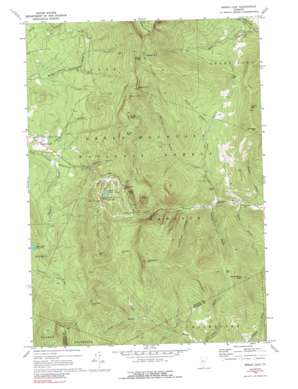
Bread Loaf Topo Map Vermont
To zoom in, hover over the map of Bread Loaf
USGS Topo Quad 43072h8 - 1:24,000 scale
| Topo Map Name: | Bread Loaf |
| USGS Topo Quad ID: | 43072h8 |
| Print Size: | ca. 21 1/4" wide x 27" high |
| Southeast Coordinates: | 43.875° N latitude / 72.875° W longitude |
| Map Center Coordinates: | 43.9375° N latitude / 72.9375° W longitude |
| U.S. State: | VT |
| Filename: | o43072h8.jpg |
| Download Map JPG Image: | Bread Loaf topo map 1:24,000 scale |
| Map Type: | Topographic |
| Topo Series: | 7.5´ |
| Map Scale: | 1:24,000 |
| Source of Map Images: | United States Geological Survey (USGS) |
| Alternate Map Versions: |
Bread Loaf VT 1970, updated 1973 Download PDF Buy paper map Bread Loaf VT 1970, updated 1977 Download PDF Buy paper map Bread Loaf VT 1970, updated 1989 Download PDF Buy paper map Bread Loaf VT 1997, updated 2000 Download PDF Buy paper map Bread Loaf VT 2012 Download PDF Buy paper map Bread Loaf VT 2015 Download PDF Buy paper map |
| FStopo: | US Forest Service topo Bread Loaf is available: Download FStopo PDF Download FStopo TIF |
1:24,000 Topo Quads surrounding Bread Loaf
> Back to 43072e1 at 1:100,000 scale
> Back to 43072a1 at 1:250,000 scale
> Back to U.S. Topo Maps home
Bread Loaf topo map: Gazetteer
Bread Loaf: Areas
Middlebury College Snow Bowl elevation 680m 2230′Bread Loaf: Cliffs
Silent Cliff elevation 754m 2473′Bread Loaf: Falls
Bailey Falls elevation 510m 1673′Texas Falls elevation 366m 1200′
Bread Loaf: Gaps
Middlebury Gap elevation 653m 2142′Monastery Gap elevation 725m 2378′
Pine Gap elevation 784m 2572′
Texas Gap elevation 674m 2211′
Bread Loaf: Lakes
Pleiad Lake elevation 655m 2148′Skylight Pond elevation 1017m 3336′
Bread Loaf: Parks
Battell Park elevation 760m 2493′Bread Loaf: Populated Places
Branch School (historical) elevation 323m 1059′Bread Loaf elevation 438m 1437′
Bread Loaf: Streams
Boyden Brook elevation 346m 1135′Clark Brook elevation 402m 1318′
Crystal Brook elevation 490m 1607′
Falls Brook elevation 456m 1496′
George Brook elevation 520m 1706′
Goshen Brook elevation 434m 1423′
Grindstone Brook elevation 379m 1243′
Piper Brook elevation 320m 1049′
Robbins Branch elevation 341m 1118′
Taylor Brook elevation 312m 1023′
Texas Brook elevation 413m 1354′
Bread Loaf: Summits
Battell Mountain elevation 1045m 3428′Boyce Mountain elevation 990m 3248′
Burnt Hill elevation 918m 3011′
Childs Mountain elevation 830m 2723′
Fassett Hill elevation 604m 1981′
Gillespie Mountain elevation 898m 2946′
Hat Crown elevation 756m 2480′
Kirby Peak elevation 936m 3070′
Monastery Mountain elevation 984m 3228′
Philadelphia Peak elevation 973m 3192′
Romance Mountain elevation 926m 3038′
Worth Mountain elevation 983m 3225′
Bread Loaf: Trails
Burnt Hill Trail elevation 661m 2168′Long Trail elevation 818m 2683′
Skylight Pond Trail elevation 737m 2417′
Sucker Brook Trail elevation 624m 2047′
Windows Trail elevation 477m 1564′
Bread Loaf digital topo map on disk
Buy this Bread Loaf topo map showing relief, roads, GPS coordinates and other geographical features, as a high-resolution digital map file on DVD:
New York, Vermont, Connecticut & Western Massachusetts
Buy digital topo maps: New York, Vermont, Connecticut & Western Massachusetts


