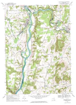
Schuylerville Topo Map New York
To zoom in, hover over the map of Schuylerville
USGS Topo Quad 43073a5 - 1:24,000 scale
| Topo Map Name: | Schuylerville |
| USGS Topo Quad ID: | 43073a5 |
| Print Size: | ca. 21 1/4" wide x 27" high |
| Southeast Coordinates: | 43° N latitude / 73.5° W longitude |
| Map Center Coordinates: | 43.0625° N latitude / 73.5625° W longitude |
| U.S. State: | NY |
| Filename: | o43073a5.jpg |
| Download Map JPG Image: | Schuylerville topo map 1:24,000 scale |
| Map Type: | Topographic |
| Topo Series: | 7.5´ |
| Map Scale: | 1:24,000 |
| Source of Map Images: | United States Geological Survey (USGS) |
| Alternate Map Versions: |
Schuylerville NY 1935 Download PDF Buy paper map Schuylerville NY 1967, updated 1970 Download PDF Buy paper map Schuylerville NY 2010 Download PDF Buy paper map Schuylerville NY 2013 Download PDF Buy paper map Schuylerville NY 2016 Download PDF Buy paper map |
1:24,000 Topo Quads surrounding Schuylerville
> Back to 43073a1 at 1:100,000 scale
> Back to 43072a1 at 1:250,000 scale
> Back to U.S. Topo Maps home
Schuylerville topo map: Gazetteer
Schuylerville: Airports
Garnseys Airport elevation 23m 75′Schuylerville: Bays
The Cove elevation 23m 75′Schuylerville: Crossings
Powers-Briggs Ferry (historical) elevation 23m 75′Schuylerville: Dams
Lock Number 5 elevation 30m 98′Schuylerville: Parks
Fort Hardy Park elevation 28m 91′Saratoga Battle Monument elevation 98m 321′
Schuylerville: Populated Places
Clarks Mills elevation 37m 121′Coveville elevation 34m 111′
Grangerville elevation 62m 203′
Middle Falls elevation 97m 318′
North Easton elevation 119m 390′
Schuylerville elevation 39m 127′
Starks Knob elevation 40m 131′
Victory Mills elevation 62m 203′
Schuylerville: Streams
Batten Kill elevation 25m 82′Batten Kill elevation 25m 82′
Ensign Brook elevation 24m 78′
Fish Creek elevation 24m 78′
Flately Brook elevation 23m 75′
Fryer Brook elevation 23m 75′
Hartshorn Brook elevation 85m 278′
McAuley Brook elevation 23m 75′
Schuyler Brook elevation 23m 75′
Schuylerville: Summits
Becker Hill elevation 333m 1092′Cement Mountain elevation 101m 331′
Holmes Hill elevation 55m 180′
Schuyler Mountain elevation 304m 997′
Whelden Mountain elevation 368m 1207′
Willard Mountain elevation 423m 1387′
Schuylerville: Trails
Fraser Burial Site Trail elevation 44m 144′Schuylerville: Valleys
Great Ravine elevation 28m 91′Schuylerville digital topo map on disk
Buy this Schuylerville topo map showing relief, roads, GPS coordinates and other geographical features, as a high-resolution digital map file on DVD:
New York, Vermont, Connecticut & Western Massachusetts
Buy digital topo maps: New York, Vermont, Connecticut & Western Massachusetts


