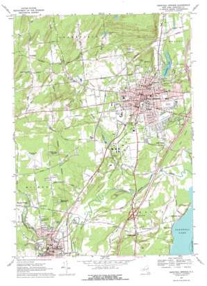
Saratoga Springs Topo Map New York
To zoom in, hover over the map of Saratoga Springs
USGS Topo Quad 43073a7 - 1:24,000 scale
| Topo Map Name: | Saratoga Springs |
| USGS Topo Quad ID: | 43073a7 |
| Print Size: | ca. 21 1/4" wide x 27" high |
| Southeast Coordinates: | 43° N latitude / 73.75° W longitude |
| Map Center Coordinates: | 43.0625° N latitude / 73.8125° W longitude |
| U.S. State: | NY |
| Filename: | o43073a7.jpg |
| Download Map JPG Image: | Saratoga Springs topo map 1:24,000 scale |
| Map Type: | Topographic |
| Topo Series: | 7.5´ |
| Map Scale: | 1:24,000 |
| Source of Map Images: | United States Geological Survey (USGS) |
| Alternate Map Versions: |
Saratoga Springs NY 1934 Download PDF Buy paper map Saratoga Springs NY 1967, updated 1969 Download PDF Buy paper map Saratoga Springs NY 1967, updated 1977 Download PDF Buy paper map Saratoga Springs NY 2010 Download PDF Buy paper map Saratoga Springs NY 2013 Download PDF Buy paper map Saratoga Springs NY 2016 Download PDF Buy paper map |
1:24,000 Topo Quads surrounding Saratoga Springs
> Back to 43073a1 at 1:100,000 scale
> Back to 43072a1 at 1:250,000 scale
> Back to U.S. Topo Maps home
Saratoga Springs topo map: Gazetteer
Saratoga Springs: Airports
Saratoga County Airport elevation 131m 429′Saratoga Springs: Crossings
Interchange 13 elevation 81m 265′Interchange 14 elevation 70m 229′
Interchange 15 elevation 94m 308′
Saratoga Springs: Lakes
Footes Pond elevation 84m 275′Granite Lake elevation 137m 449′
Haupt Pond elevation 122m 400′
Loughberry Lake elevation 86m 282′
Saratoga Springs: Parks
Abner Doubleday Baseball Field elevation 88m 288′Burgess Kimball Memorial Park elevation 131m 429′
Castle Baseball Diamond elevation 102m 334′
Congress Park elevation 84m 275′
Geyser Park elevation 101m 331′
North Side Recreation Park elevation 115m 377′
Porter Plaza elevation 131m 429′
Saratoga Spa State Park elevation 86m 282′
Wachenheim Field elevation 123m 403′
William Kelley Memorial Park elevation 71m 232′
Saratoga Springs: Populated Places
Ballston Spa elevation 96m 314′Birch Acres elevation 97m 318′
Birch Run elevation 116m 380′
Brookview Village Mobile Home Park elevation 196m 643′
Chris Mobile Home Park elevation 109m 357′
Coachman Estates elevation 124m 406′
Country Acres Trailer Park elevation 131m 429′
Country Manor Trailer Court elevation 115m 377′
Country Squire Estates elevation 118m 387′
Daniel Corners Trailer Park elevation 150m 492′
Deer Run elevation 131m 429′
Eddy Corners elevation 89m 291′
Evergreen Point elevation 100m 328′
Factory Village elevation 111m 364′
Francis Corners elevation 95m 311′
Geyser Crest elevation 107m 351′
Geyser Gates elevation 130m 426′
Grange Road Mobile Estates elevation 174m 570′
Greenfield elevation 180m 590′
Heritage Manor elevation 101m 331′
Hidden Acres Mobile Court elevation 127m 416′
Independence Square elevation 81m 265′
Juniper Acres elevation 126m 413′
Lakeside Acres elevation 63m 206′
Lakewood Estates elevation 92m 301′
Loughberry Mobile Home Park elevation 97m 318′
Malta Ridge elevation 102m 334′
Mannings Cove elevation 67m 219′
Milton elevation 128m 419′
Milton Heights elevation 128m 419′
Milton Manor elevation 129m 423′
Milton Oaks elevation 129m 423′
Riley Cove elevation 62m 203′
Sabre Springs elevation 198m 649′
Saratoga Estates elevation 96m 314′
Saratoga Mobile Home Park elevation 99m 324′
Saratoga Springs elevation 91m 298′
Saratoga West Mobile Home Park elevation 131m 429′
Sherwood Forest elevation 100m 328′
South Greenfield elevation 179m 587′
The Meadows elevation 98m 321′
The Springs elevation 99m 324′
Travers Manor elevation 100m 328′
Trotterview Trailer Park elevation 95m 311′
Utters Mobile Home Park elevation 126m 413′
Victoria Gardens elevation 92m 301′
Woodland Court elevation 127m 416′
Yaddo elevation 96m 314′
Saratoga Springs: Reservoirs
Ballston Spa Reservoir elevation 114m 374′Ballston Spa Reservoir elevation 113m 370′
Cooks Pond elevation 95m 311′
Saratoga Springs: Ridges
Malta Ridge elevation 101m 331′Saratoga Springs: Springs
High Rock Spring elevation 81m 265′Old Red Spring elevation 81m 265′
Saratoga Springs: Streams
Bell Brook elevation 97m 318′Drummond Creek elevation 63m 206′
Geyser Brook elevation 64m 209′
Gordon Creek elevation 71m 232′
Mourning Kill elevation 65m 213′
Putnam Brook elevation 97m 318′
Rowland Hollow Creek elevation 97m 318′
Sessleman Brook elevation 151m 495′
Slade Creek elevation 97m 318′
Wheeler Creek elevation 111m 364′
Saratoga Springs: Summits
Pelton Hill elevation 84m 275′Saratoga Springs digital topo map on disk
Buy this Saratoga Springs topo map showing relief, roads, GPS coordinates and other geographical features, as a high-resolution digital map file on DVD:
New York, Vermont, Connecticut & Western Massachusetts
Buy digital topo maps: New York, Vermont, Connecticut & Western Massachusetts


