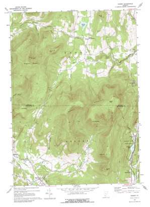
Dorset Topo Map Vermont
To zoom in, hover over the map of Dorset
USGS Topo Quad 43073c1 - 1:24,000 scale
| Topo Map Name: | Dorset |
| USGS Topo Quad ID: | 43073c1 |
| Print Size: | ca. 21 1/4" wide x 27" high |
| Southeast Coordinates: | 43.25° N latitude / 73° W longitude |
| Map Center Coordinates: | 43.3125° N latitude / 73.0625° W longitude |
| U.S. State: | VT |
| Filename: | o43073c1.jpg |
| Download Map JPG Image: | Dorset topo map 1:24,000 scale |
| Map Type: | Topographic |
| Topo Series: | 7.5´ |
| Map Scale: | 1:24,000 |
| Source of Map Images: | United States Geological Survey (USGS) |
| Alternate Map Versions: |
Dorset VT 1967, updated 1972 Download PDF Buy paper map Dorset VT 1967, updated 1976 Download PDF Buy paper map Dorset VT 1997, updated 2000 Download PDF Buy paper map Dorset VT 2012 Download PDF Buy paper map Dorset VT 2015 Download PDF Buy paper map |
| FStopo: | US Forest Service topo Dorset is available: Download FStopo PDF Download FStopo TIF |
1:24,000 Topo Quads surrounding Dorset
> Back to 43073a1 at 1:100,000 scale
> Back to 43072a1 at 1:250,000 scale
> Back to U.S. Topo Maps home
Dorset topo map: Gazetteer
Dorset: Bridges
Emerald Lake Natural Bridge elevation 377m 1236′Dorset: Cliffs
The Ox Bow elevation 651m 2135′Dorset: Forests
Emerald Lake State Forest elevation 274m 898′Dorset: Lakes
Danby Pond elevation 428m 1404′Emerald Lake elevation 217m 711′
Prentiss Pond elevation 284m 931′
Dorset: Mines
Danby Marble Quarry (historical) elevation 335m 1099′Freedley Quarry elevation 596m 1955′
Dorset: Parks
Emerald Lake State Park elevation 298m 977′Dorset: Populated Places
Danby Four Corners elevation 442m 1450′Dorset elevation 292m 958′
Freedleyville elevation 242m 793′
North Dorset elevation 219m 718′
Dorset: Post Offices
Dorset Post Office elevation 286m 938′Dorset: Streams
Fall Brook elevation 328m 1076′Gulf Brook elevation 213m 698′
Mountain Brook elevation 319m 1046′
Prentiss Brook elevation 257m 843′
Weatherby Brook elevation 418m 1371′
Dorset: Summits
Colvin Hill elevation 532m 1745′Danby Hill elevation 618m 2027′
Dorset Hill elevation 843m 2765′
Dorset Mountain elevation 1148m 3766′
Dorset Peak elevation 1147m 3763′
Netop Mountain elevation 874m 2867′
Parris Hill elevation 805m 2641′
The Mettawee elevation 854m 2801′
The Scallop elevation 704m 2309′
Woodlawn Mountain elevation 946m 3103′
Dorset: Valleys
Dorset Hollow elevation 302m 990′Kirby Hollow elevation 282m 925′
Dorset digital topo map on disk
Buy this Dorset topo map showing relief, roads, GPS coordinates and other geographical features, as a high-resolution digital map file on DVD:
New York, Vermont, Connecticut & Western Massachusetts
Buy digital topo maps: New York, Vermont, Connecticut & Western Massachusetts


