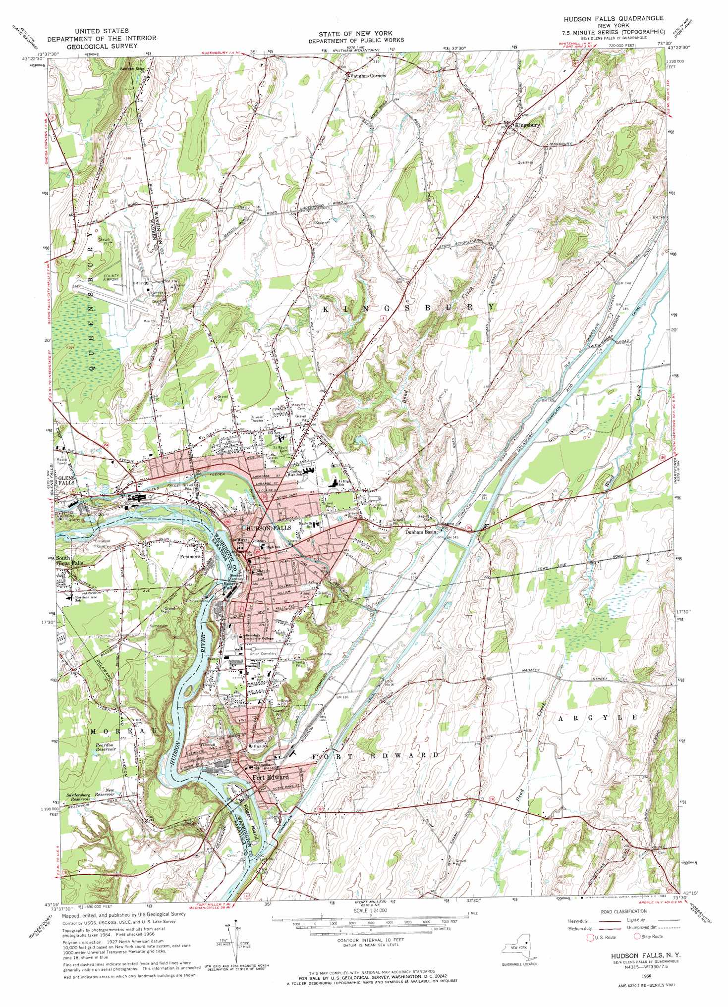
Hudson Falls Topo Map New York
To zoom in, hover over the map of Hudson Falls
USGS Topo Quad 43073c5 - 1:24,000 scale
| Topo Map Name: | Hudson Falls |
| USGS Topo Quad ID: | 43073c5 |
| Print Size: | ca. 21 1/4" wide x 27" high |
| Southeast Coordinates: | 43.25° N latitude / 73.5° W longitude |
| Map Center Coordinates: | 43.3125° N latitude / 73.5625° W longitude |
| U.S. State: | NY |
| Filename: | o43073c5.jpg |
| Download Map JPG Image: | Hudson Falls topo map 1:24,000 scale |
| Map Type: | Topographic |
| Topo Series: | 7.5´ |
| Map Scale: | 1:24,000 |
| Source of Map Images: | United States Geological Survey (USGS) |
| Alternate Map Versions: |
Hudson Falls NY 1966, updated 1968 Download PDF Buy paper map Hudson Falls NY 1966, updated 1984 Download PDF Buy paper map Hudson Falls NY 1966, updated 1984 Download PDF Buy paper map Hudson Falls NY 2010 Download PDF Buy paper map Hudson Falls NY 2013 Download PDF Buy paper map Hudson Falls NY 2016 Download PDF Buy paper map |
1:24,000 Topo Quads surrounding Hudson Falls
The Glen |
Bolton Landing |
Shelving Rock |
Whitehall |
Thorn Hill |
Warrensburg |
Lake George |
Putnam Mountain |
Fort Ann |
Granville |
Lake Luzerne |
Glens Falls |
Hudson Falls |
Hartford |
West Pawlet |
Corinth |
Gansevoort |
Fort Miller |
Cossayuna |
Salem |
Saratoga Springs |
Quaker Springs |
Schuylerville |
Cambridge |
Shushan |
> Back to 43073a1 at 1:100,000 scale
> Back to 43072a1 at 1:250,000 scale
> Back to U.S. Topo Maps home
Hudson Falls topo map: Gazetteer
Hudson Falls: Airports
Warren County Airport elevation 97m 318′Hudson Falls: Canals
Glens Falls Feeder Canal elevation 85m 278′Old Champlain Canal elevation 46m 150′
Hudson Falls: Dams
Lock Number 7 elevation 40m 131′Lock Number 8 elevation 39m 127′
Hudson Falls: Falls
Bakers Falls elevation 61m 200′Hudson Falls: Islands
Rogers Island elevation 38m 124′Hudson Falls: Parks
Derby Park elevation 84m 275′Hudson Falls Historic District elevation 88m 288′
Underwood Park elevation 39m 127′
Hudson Falls: Populated Places
Bluebird Knolls Trailer Park elevation 100m 328′Country Acres elevation 89m 291′
Dix Mobile Home Park elevation 89m 291′
Fenimore elevation 80m 262′
Fort Edward elevation 42m 137′
Hudson Falls elevation 90m 295′
King Edward Knolls elevation 63m 206′
Kingsbury elevation 93m 305′
Sunset Hill Downs elevation 69m 226′
Vaughns Corners elevation 97m 318′
Hudson Falls: Reservoirs
New Reservoir elevation 76m 249′Reardon Reservoir elevation 85m 278′
Sardersberg Reservoir elevation 79m 259′
Hudson Falls: Streams
Bond Creek elevation 39m 127′Hudson Falls digital topo map on disk
Buy this Hudson Falls topo map showing relief, roads, GPS coordinates and other geographical features, as a high-resolution digital map file on DVD:
New York, Vermont, Connecticut & Western Massachusetts
Buy digital topo maps: New York, Vermont, Connecticut & Western Massachusetts