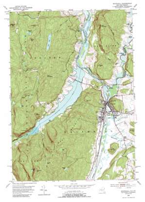
Whitehall Topo Map New York
To zoom in, hover over the map of Whitehall
USGS Topo Quad 43073e4 - 1:24,000 scale
| Topo Map Name: | Whitehall |
| USGS Topo Quad ID: | 43073e4 |
| Print Size: | ca. 21 1/4" wide x 27" high |
| Southeast Coordinates: | 43.5° N latitude / 73.375° W longitude |
| Map Center Coordinates: | 43.5625° N latitude / 73.4375° W longitude |
| U.S. States: | NY, VT |
| Filename: | o43073e4.jpg |
| Download Map JPG Image: | Whitehall topo map 1:24,000 scale |
| Map Type: | Topographic |
| Topo Series: | 7.5´ |
| Map Scale: | 1:24,000 |
| Source of Map Images: | United States Geological Survey (USGS) |
| Alternate Map Versions: |
Whitehall NY 1950, updated 1966 Download PDF Buy paper map Whitehall NY 1950, updated 1966 Download PDF Buy paper map Whitehall NY 1950, updated 1975 Download PDF Buy paper map Whitehall NY 1950, updated 1990 Download PDF Buy paper map Whitehall NY 2011 Download PDF Buy paper map Whitehall NY 2013 Download PDF Buy paper map Whitehall NY 2016 Download PDF Buy paper map |
1:24,000 Topo Quads surrounding Whitehall
> Back to 43073e1 at 1:100,000 scale
> Back to 43072a1 at 1:250,000 scale
> Back to U.S. Topo Maps home
Whitehall topo map: Gazetteer
Whitehall: Bays
East Bay elevation 29m 95′South Bay elevation 29m 95′
Whitehall: Bends
The Elbow elevation 29m 95′Whitehall: Bridges
South Bay Causeway elevation 29m 95′Whitehall: Dams
Lock Twelve elevation 29m 95′Whitehall: Guts
East Bay elevation 29m 95′Wood Creek elevation 29m 95′
Wood Creek elevation 32m 104′
Whitehall: Lakes
Clear Pond elevation 322m 1056′Mud Pond elevation 277m 908′
Pine Lake elevation 292m 958′
Sawmill Pond elevation 259m 849′
Sheltered Lakes elevation 417m 1368′
Spectacle Pond elevation 401m 1315′
Vanderburg Pond elevation 419m 1374′
Whitehall: Mines
Hooper Mine elevation 351m 1151′South Bay Quarry elevation 256m 839′
Whitehall: Parks
Main Street Historic District elevation 42m 137′Riverside Park elevation 30m 98′
Ward Marsh Wildlife Management Area elevation 33m 108′
Whitehall: Pillars
Death Rock elevation 253m 830′Devils Pulpit elevation 29m 95′
Whitehall: Populated Places
Grays Corner elevation 49m 160′Whitehall elevation 48m 157′
Whitehall Mobile Home Park elevation 41m 134′
Whitehall: Reservoirs
Whitehall Reservoir elevation 126m 413′Whitehall: Springs
Cold Spring elevation 29m 95′Whitehall: Streams
Big Hollow Brook elevation 30m 98′Bumps Brook elevation 29m 95′
Greenland Brook elevation 27m 88′
Mettawee River elevation 29m 95′
Mettawee River elevation 29m 95′
Mud Brook elevation 29m 95′
Pike Brook elevation 31m 101′
Pine Lake Brook elevation 39m 127′
South Bay Creek elevation 29m 95′
Whitehall: Summits
Austin Hill elevation 196m 643′Bald Mountain elevation 328m 1076′
Bald Mountain elevation 379m 1243′
Berry Hill elevation 516m 1692′
Black Lead Hill elevation 362m 1187′
Little Diameter elevation 225m 738′
Ore Bed Hill elevation 110m 360′
Skene Mountain elevation 162m 531′
Sugarloaf Mountain elevation 596m 1955′
The Diameter elevation 272m 892′
The Knob elevation 464m 1522′
The Saddles elevation 412m 1351′
Tub Mountain elevation 143m 469′
Vanderburg Mountain elevation 584m 1916′
Warner Hill elevation 153m 501′
West Mountain elevation 414m 1358′
Whitehall: Swamps
Billings Marsh elevation 30m 98′Cat Den Bay elevation 31m 101′
Drowned Lands elevation 30m 98′
Duso Marsh elevation 30m 98′
Schoolhouse Marsh elevation 29m 95′
Timber Marsh elevation 30m 98′
Ward Marsh elevation 30m 98′
Whitehall digital topo map on disk
Buy this Whitehall topo map showing relief, roads, GPS coordinates and other geographical features, as a high-resolution digital map file on DVD:
New York, Vermont, Connecticut & Western Massachusetts
Buy digital topo maps: New York, Vermont, Connecticut & Western Massachusetts


