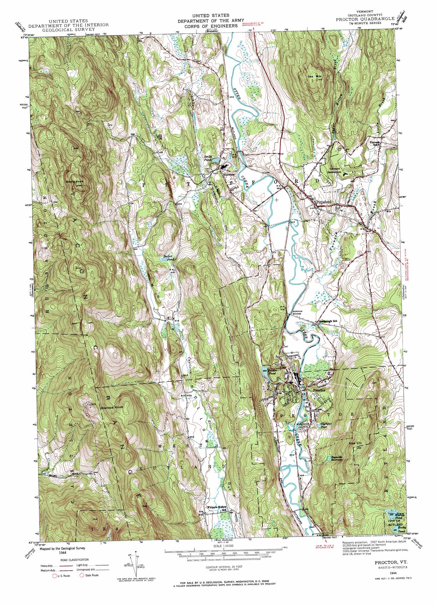
Proctor Topo Map Vermont
To zoom in, hover over the map of Proctor
USGS Topo Quad 43073f1 - 1:24,000 scale
| Topo Map Name: | Proctor |
| USGS Topo Quad ID: | 43073f1 |
| Print Size: | ca. 21 1/4" wide x 27" high |
| Southeast Coordinates: | 43.625° N latitude / 73° W longitude |
| Map Center Coordinates: | 43.6875° N latitude / 73.0625° W longitude |
| U.S. State: | VT |
| Filename: | o43073f1.jpg |
| Download Map JPG Image: | Proctor topo map 1:24,000 scale |
| Map Type: | Topographic |
| Topo Series: | 7.5´ |
| Map Scale: | 1:24,000 |
| Source of Map Images: | United States Geological Survey (USGS) |
| Alternate Map Versions: |
Proctor VT 1944, updated 1958 Download PDF Buy paper map Proctor VT 1944, updated 1972 Download PDF Buy paper map Proctor VT 2012 Download PDF Buy paper map Proctor VT 2015 Download PDF Buy paper map |
1:24,000 Topo Quads surrounding Proctor
Bridport |
Cornwall |
East Middlebury |
Bread Loaf |
Hancock |
Orwell |
Sudbury |
Brandon |
Mount Carmel |
Rochester |
Benson |
Bomoseen |
Proctor |
Chittenden |
Pico Peak |
Thorn Hill |
Poultney |
West Rutland |
Rutland |
Killington Peak |
Granville |
Wells |
Middletown Springs |
Wallingford |
Mount Holly |
> Back to 43073e1 at 1:100,000 scale
> Back to 43072a1 at 1:250,000 scale
> Back to U.S. Topo Maps home
Proctor topo map: Gazetteer
Proctor: Bays
Warner Cove elevation 144m 472′Proctor: Bridges
Colburn Bridge elevation 150m 492′Cooley Covered Bridge elevation 111m 364′
Depot Covered Bridge elevation 112m 367′
Gorham Bridge elevation 121m 396′
Hammond Covered Bridge elevation 108m 354′
Proctor: Dams
Beaver Pond Dam elevation 171m 561′Proctor Dam elevation 143m 469′
Proctor: Falls
Sutherland Falls elevation 142m 465′Proctor: Forests
Proctor Village Municipal Forest elevation 354m 1161′Rutland Municipal Forest elevation 211m 692′
West Rutland State Forest elevation 494m 1620′
Proctor: Lakes
Butler Pond elevation 203m 666′Muddy Pond elevation 253m 830′
Olympus Pool elevation 162m 531′
Rocky Pond elevation 265m 869′
Sargent Pond elevation 171m 561′
Smith Pond elevation 125m 410′
Proctor: Parks
Pittsford Green Historic District elevation 172m 564′Whipple Hollow Wildlife Management Area elevation 265m 869′
Proctor: Populated Places
Florence elevation 131m 429′Grangerville elevation 160m 524′
Pittsford elevation 172m 564′
Proctor elevation 153m 501′
Proctor: Post Offices
Pittsford Post Office elevation 167m 547′Proctor Post Office elevation 149m 488′
Proctor: Reservoirs
Beaver Pond elevation 171m 561′Reynolds Reservoir elevation 247m 810′
Sugar Hollow Pond elevation 193m 633′
Proctor: Streams
Furnace Brook elevation 114m 374′Little Brook elevation 148m 485′
Sugar Hollow Brook elevation 115m 377′
Proctor: Summits
Biddie Knob elevation 601m 1971′Cox Mountain elevation 443m 1453′
Grandpa Knob elevation 493m 1617′
Pine Hill elevation 435m 1427′
Proctor digital topo map on disk
Buy this Proctor topo map showing relief, roads, GPS coordinates and other geographical features, as a high-resolution digital map file on DVD:
New York, Vermont, Connecticut & Western Massachusetts
Buy digital topo maps: New York, Vermont, Connecticut & Western Massachusetts