Bomoseen Topo Map Vermont
To zoom in, hover over the map of Bomoseen
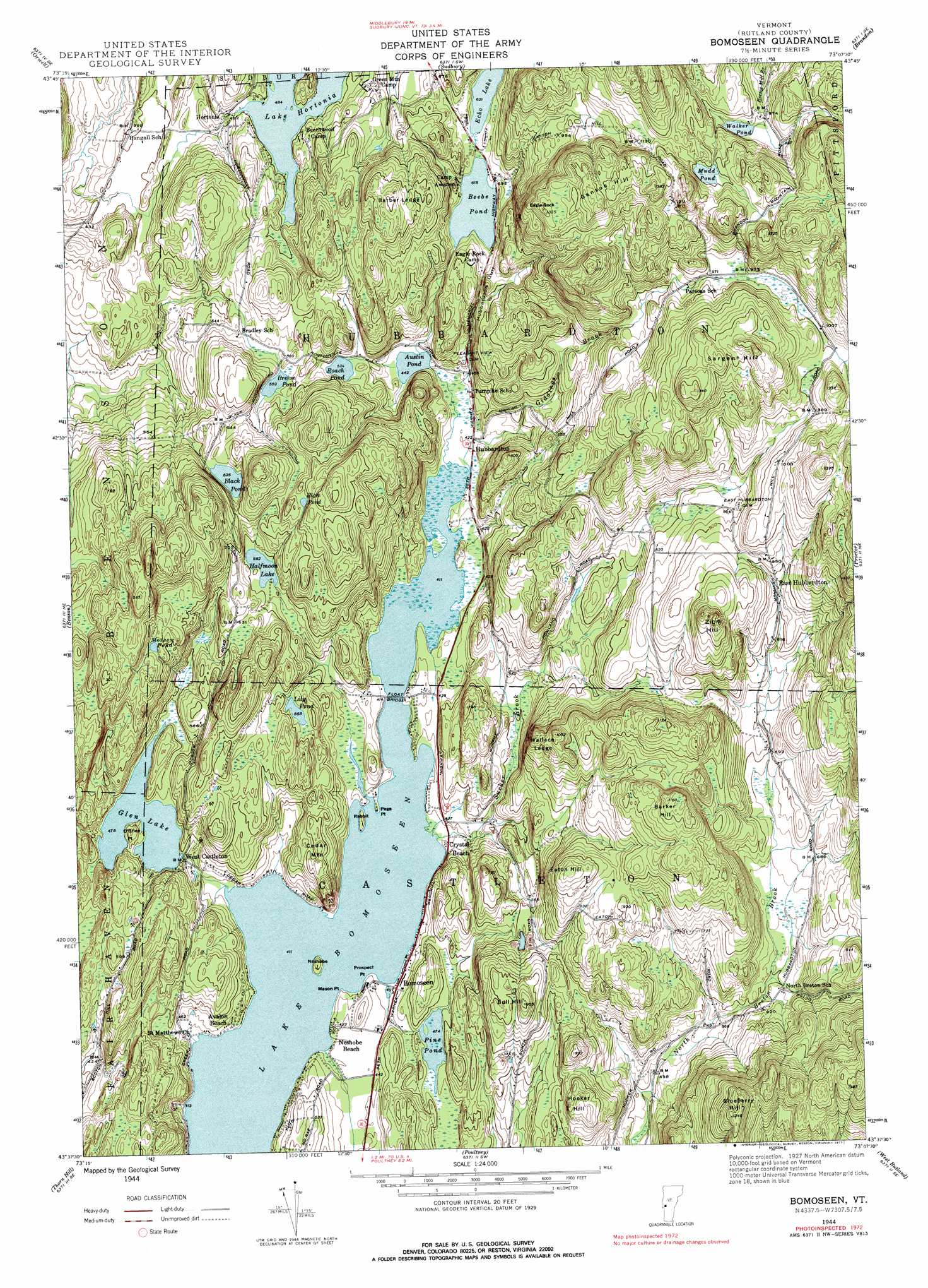
USGS Topo Quad 43073f2 - 1:24,000 scale
| Topo Map Name: | Bomoseen |
| USGS Topo Quad ID: | 43073f2 |
| Print Size: | ca. 21 1/4" wide x 27" high |
| Southeast Coordinates: | 43.625° N latitude / 73.125° W longitude |
| Map Center Coordinates: | 43.6875° N latitude / 73.1875° W longitude |
| U.S. State: | VT |
| Filename: | o43073f2.jpg |
| Download Map JPG Image: | Bomoseen topo map 1:24,000 scale |
| Map Type: | Topographic |
| Topo Series: | 7.5´ |
| Map Scale: | 1:24,000 |
| Source of Map Images: | United States Geological Survey (USGS) |
| Alternate Map Versions: |
Bomoseen VT 1944, updated 1958 Download PDF Buy paper map Bomoseen VT 1944, updated 1968 Download PDF Buy paper map Bomoseen VT 1944, updated 1977 Download PDF Buy paper map Bomoseen VT 2012 Download PDF Buy paper map Bomoseen VT 2015 Download PDF Buy paper map |
1:24,000 Topo Quads surrounding Bomoseen
Crown Point |
Bridport |
Cornwall |
East Middlebury |
Bread Loaf |
Ticonderoga |
Orwell |
Sudbury |
Brandon |
Mount Carmel |
Putnam |
Benson |
Bomoseen |
Proctor |
Chittenden |
Whitehall |
Thorn Hill |
Poultney |
West Rutland |
Rutland |
Fort Ann |
Granville |
Wells |
Middletown Springs |
Wallingford |
> Back to 43073e1 at 1:100,000 scale
> Back to 43072a1 at 1:250,000 scale
> Back to U.S. Topo Maps home
Bomoseen topo map: Gazetteer
Bomoseen: Bridges
Float Bridge elevation 125m 410′Bomoseen: Capes
Cedar Point elevation 125m 410′Mason Point elevation 134m 439′
O'Brien Point elevation 166m 544′
Page Point elevation 125m 410′
Prospect Point elevation 130m 426′
Bomoseen: Cliffs
Barber Ledge elevation 295m 967′Wallace Ledge elevation 252m 826′
Bomoseen: Dams
Austin Pond Dam elevation 135m 442′Chizmar Dam elevation 157m 515′
Glen Lake Dam elevation 154m 505′
Lake Hortonia Dam elevation 207m 679′
Loves Marsh Dam elevation 140m 459′
Munger Dam elevation 139m 456′
Pine Pond Dam elevation 144m 472′
Said Dam elevation 169m 554′
Walker Pond Dam elevation 295m 967′
Bomoseen: Forests
Castleton Municipal Forest elevation 139m 456′Bomoseen: Islands
Neshobe Island elevation 139m 456′Rabbit Island elevation 125m 410′
Bomoseen: Lakes
Beebe Pond elevation 188m 616′Black Pond elevation 191m 626′
Breese Pond elevation 168m 551′
Echo Lake elevation 189m 620′
Halfmoon Lake elevation 177m 580′
High Pond elevation 261m 856′
Lake Bomoseen elevation 125m 410′
Lily Pond elevation 173m 567′
Moscow Pond elevation 223m 731′
Mudd Pond elevation 332m 1089′
Roach Pond elevation 163m 534′
Said Pond elevation 156m 511′
Walker Pond elevation 290m 951′
Wheeler Pond elevation 146m 479′
Bomoseen: Parks
Bomoseen State Park elevation 219m 718′Bomossen Wildlife Reserve elevation 211m 692′
Hubbardton Battle Monument elevation 315m 1033′
Hubbardton Battlefield elevation 340m 1115′
Hubbardton Battlefield Wildlife Management Area elevation 341m 1118′
Marsh Pond Wildlife Management Area elevation 206m 675′
Bomoseen: Populated Places
Avalon Beach elevation 141m 462′Bomoseen elevation 135m 442′
Crystal Beach elevation 138m 452′
East Hubbardton elevation 294m 964′
Hortonia elevation 150m 492′
Hubbardton elevation 134m 439′
Neshobe Beach elevation 142m 465′
Ransomvale elevation 216m 708′
West Castleton elevation 145m 475′
Bomoseen: Reservoirs
Austin Pond elevation 135m 442′Glen Lake elevation 146m 479′
Lake Hortonia elevation 148m 485′
Loves Marsh elevation 140m 459′
Pine Pond elevation 144m 472′
Bomoseen: Streams
Giddings Brook elevation 126m 413′Sucker Brook elevation 125m 410′
Bomoseen: Summits
Barker Hill elevation 365m 1197′Blueberry Hill elevation 381m 1250′
Bull Hill elevation 285m 935′
Cedar Mountain elevation 201m 659′
Eagle Rock elevation 414m 1358′
Eaton Hill elevation 307m 1007′
Ganson Hill elevation 418m 1371′
Hooker Hill elevation 277m 908′
Sargent Hill elevation 409m 1341′
Zion Hill elevation 368m 1207′
Bomoseen: Swamps
Beaver Meadow elevation 222m 728′Bomoseen: Trails
Bomoseen Hiking Loop elevation 198m 649′Daniel Coffey Memorial Trial elevation 241m 790′
Glen Lake Trail elevation 190m 623′
Half Moon Pond Trail elevation 176m 577′
Vermont State History Trail elevation 145m 475′
Bomoseen: Valleys
Hubbardton Gulf elevation 215m 705′Bomoseen digital topo map on disk
Buy this Bomoseen topo map showing relief, roads, GPS coordinates and other geographical features, as a high-resolution digital map file on DVD:
New York, Vermont, Connecticut & Western Massachusetts
Buy digital topo maps: New York, Vermont, Connecticut & Western Massachusetts