Cathead Mountain Topo Map New York
To zoom in, hover over the map of Cathead Mountain
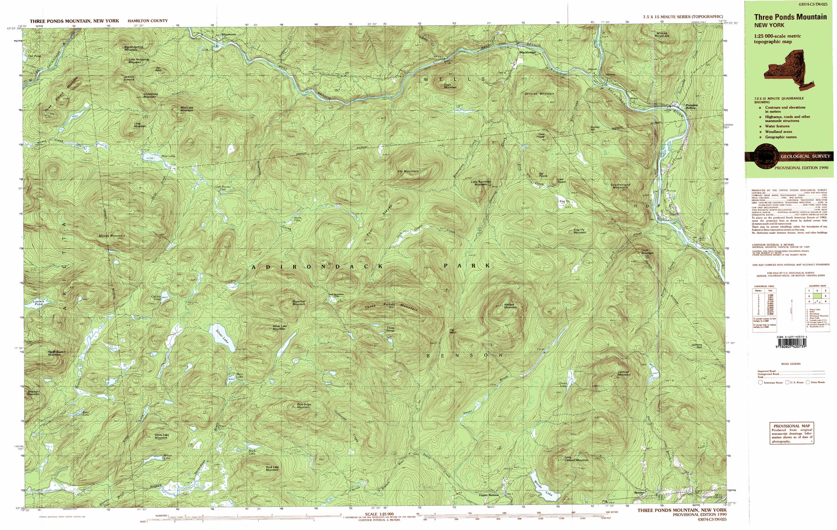
USGS Topo Quad 43074c3 - 1:25,000 scale
| Topo Map Name: | Cathead Mountain |
| USGS Topo Quad ID: | 43074c3 |
| Print Size: | ca. 39" wide x 24" high |
| Southeast Coordinates: | 43.25° N latitude / 74.25° W longitude |
| Map Center Coordinates: | 43.3125° N latitude / 74.375° W longitude |
| U.S. State: | NY |
| Filename: | k43074c3.jpg |
| Download Map JPG Image: | Cathead Mountain topo map 1:25,000 scale |
| Map Type: | Topographic |
| Topo Series: | 7.5´x15´ |
| Map Scale: | 1:25,000 |
| Source of Map Images: | United States Geological Survey (USGS) |
| Alternate Map Versions: |
Three Ponds Mountain NY 1990, updated 1990 Download PDF Buy paper map Three Ponds Mountain NY 1990, updated 1990 Download PDF Buy paper map Three Ponds Mountain NY 1997, updated 1999 Download PDF Buy paper map |
1:24,000 Topo Quads surrounding Cathead Mountain
Spruce Lake |
Kunjamuk River |
Bakers Mills |
||
Piseco Lake |
Wells |
Harrisburg |
||
Tomany Mountain |
Cathead Mountain |
Ohmer Mountain |
||
Canada Lake |
Caroga Lake |
Jackson Summit |
Northville |
Edinburg |
Lassellsville |
Peck Lake |
Gloversville |
Broadalbin |
Galway |
> Back to 43074a1 at 1:100,000 scale
> Back to 43074a1 at 1:250,000 scale
> Back to U.S. Topo Maps home
Cathead Mountain topo map: Gazetteer
Cathead Mountain: Gaps
The Notch elevation 544m 1784′Cathead Mountain: Lakes
Canary Pond elevation 612m 2007′Grant Lake elevation 458m 1502′
Loomis Pond elevation 692m 2270′
Meco Lake elevation 643m 2109′
Mud Lake elevation 528m 1732′
Owl Pond elevation 527m 1729′
Rock Lake elevation 593m 1945′
Ross Lake elevation 543m 1781′
Silver Lake elevation 632m 2073′
Three Ponds elevation 783m 2568′
White Lake elevation 593m 1945′
Woods Lake elevation 417m 1368′
Cathead Mountain: Populated Places
Benson elevation 355m 1164′Blackbridge elevation 319m 1046′
Pumpkin Hollow elevation 278m 912′
Cathead Mountain: Streams
Abner Brook elevation 397m 1302′Coulombe Creek elevation 270m 885′
Devorse Creek elevation 294m 964′
Doig Creek elevation 247m 810′
Dugway Creek elevation 380m 1246′
Goldmine Creek elevation 496m 1627′
Groff Creek elevation 250m 820′
Jack Green Creek elevation 453m 1486′
Jimmy Creek elevation 333m 1092′
King Vly Creek elevation 360m 1181′
Ninemile Creek elevation 371m 1217′
Noisy Brook elevation 528m 1732′
Petes Creek elevation 254m 833′
Remington Creek elevation 356m 1167′
Silver Lake Outlet elevation 514m 1686′
Vly Creek elevation 287m 941′
West Branch Sacandaga River elevation 291m 954′
Whitman Flow elevation 515m 1689′
Cathead Mountain: Summits
Big Hedgehog Mountain elevation 601m 1971′Big Popple elevation 493m 1617′
Blue Ridge Mountain elevation 866m 2841′
Cathead Mountain elevation 740m 2427′
Devorse Mountain elevation 550m 1804′
Finch Mountain elevation 609m 1998′
Four Staves elevation 696m 2283′
Grindstone Mountain elevation 665m 2181′
Groff Mountain elevation 540m 1771′
Jackson Summit elevation 676m 2217′
Jacksons Seat elevation 422m 1384′
King Vly Mountain elevation 543m 1781′
Little Cathead Mountain elevation 638m 2093′
Little Hedgehog Mountain elevation 610m 2001′
Little Popple elevation 501m 1643′
Little Roundtop Mountain elevation 595m 1952′
Long Mountain elevation 650m 2132′
Moose Mountain elevation 847m 2778′
Moose Mountain elevation 542m 1778′
Mud Lake Mountain elevation 680m 2230′
North Branch Mountain elevation 829m 2719′
Rock Lake Mountain elevation 698m 2290′
Rooney Hill elevation 421m 1381′
Silver Lake Mountain elevation 828m 2716′
Southerland Mountain elevation 582m 1909′
Sugarloaf Mountain elevation 874m 2867′
Third Popple elevation 463m 1519′
Three Ponds Mountain elevation 890m 2919′
Three Sisters Mountain elevation 630m 2066′
Vly Mountain elevation 737m 2417′
Wallace Mountain elevation 828m 2716′
White Lake Mountain elevation 697m 2286′
Cathead Mountain: Swamps
Cole Rooney Flow elevation 508m 1666′King Vly elevation 437m 1433′
Motts Flow elevation 537m 1761′
Cathead Mountain digital topo map on disk
Buy this Cathead Mountain topo map showing relief, roads, GPS coordinates and other geographical features, as a high-resolution digital map file on DVD:
New York, Vermont, Connecticut & Western Massachusetts
Buy digital topo maps: New York, Vermont, Connecticut & Western Massachusetts