Tomany Mountain Topo Map New York
To zoom in, hover over the map of Tomany Mountain
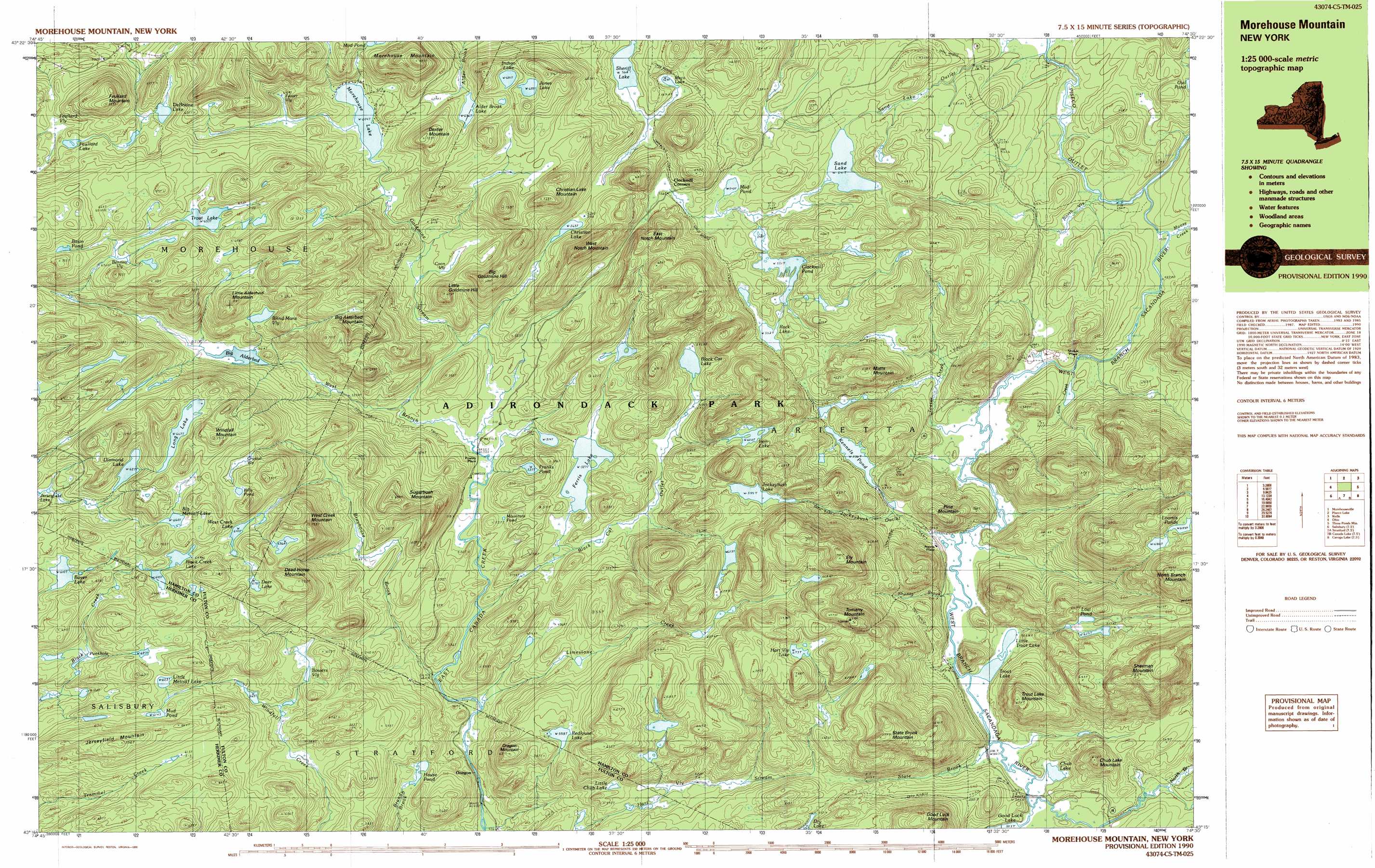
USGS Topo Quad 43074c5 - 1:25,000 scale
| Topo Map Name: | Tomany Mountain |
| USGS Topo Quad ID: | 43074c5 |
| Print Size: | ca. 39" wide x 24" high |
| Southeast Coordinates: | 43.25° N latitude / 74.5° W longitude |
| Map Center Coordinates: | 43.3125° N latitude / 74.625° W longitude |
| U.S. State: | NY |
| Filename: | k43074c5.jpg |
| Download Map JPG Image: | Tomany Mountain topo map 1:25,000 scale |
| Map Type: | Topographic |
| Topo Series: | 7.5´x15´ |
| Map Scale: | 1:25,000 |
| Source of Map Images: | United States Geological Survey (USGS) |
| Alternate Map Versions: |
Morehouse Mountain NY 1990, updated 1990 Download PDF Buy paper map |
1:24,000 Topo Quads surrounding Tomany Mountain
Honnedaga Lake |
Spruce Lake |
Kunjamuk River |
||
Morehouseville |
Piseco Lake |
Wells |
||
Jerseyfield Lake |
Tomany Mountain |
Cathead Mountain |
||
Salisbury |
Stratford |
Canada Lake |
Caroga Lake |
Jackson Summit |
Little Falls |
Oppenheim |
Lassellsville |
Peck Lake |
Gloversville |
> Back to 43074a1 at 1:100,000 scale
> Back to 43074a1 at 1:250,000 scale
> Back to U.S. Topo Maps home
Tomany Mountain topo map: Gazetteer
Tomany Mountain: Lakes
Alder Brook Lake elevation 635m 2083′Big Alderbed elevation 548m 1797′
Big Metcalf Lake elevation 663m 2175′
Bills Pond elevation 670m 2198′
Black Cat Lake elevation 543m 1781′
Black Creek Lake elevation 646m 2119′
Blind Mans Vly elevation 597m 1958′
Boyer Lake elevation 610m 2001′
Christian Lake elevation 563m 1847′
Chub Lake elevation 501m 1643′
Clockmill Pond elevation 551m 1807′
DeBraine Lake elevation 616m 2020′
Deer Lake elevation 678m 2224′
Diamond Lake elevation 627m 2057′
Dry Lake elevation 552m 1811′
Ferris Lake elevation 527m 1729′
Feullard Lake elevation 628m 2060′
Franks Pond elevation 537m 1761′
Hart Vly Lake elevation 673m 2208′
House Pond elevation 495m 1624′
Indigo Lake elevation 681m 2234′
Iron Lake elevation 609m 1998′
Jerseyfield Lake elevation 592m 1942′
Jockeybush Lake elevation 599m 1965′
Jones Lake elevation 698m 2290′
Kennels Pond elevation 536m 1758′
Little Chub Lake elevation 538m 1765′
Little Metcalf Lake elevation 621m 2037′
Little Trout Lake elevation 499m 1637′
Long Lake elevation 667m 2188′
Loomis Ponds elevation 685m 2247′
Lost Pond elevation 623m 2043′
Morehouse Lake elevation 604m 1981′
Mountain Pond elevation 520m 1706′
Mud Pond elevation 550m 1804′
Mud Pond elevation 615m 2017′
Mud Pond elevation 669m 2194′
Redlouse Lake elevation 559m 1833′
Rock Lake elevation 553m 1814′
Sand Lake elevation 541m 1774′
Sheriff Lake elevation 568m 1863′
Trout Lake elevation 499m 1637′
Trout Lake elevation 653m 2142′
West Creek Lake elevation 644m 2112′
Tomany Mountain: Populated Places
Averys Place elevation 521m 1709′Oregon elevation 444m 1456′
Powley Place elevation 510m 1673′
Shaker Place elevation 500m 1640′
Tomany Mountain: Streams
Black Cat Outlet elevation 483m 1584′Brayhouse Brook elevation 468m 1535′
Cow Creek elevation 504m 1653′
Goldmine Stream elevation 505m 1656′
Jockeybush Outlet elevation 499m 1637′
Limestone Creek elevation 460m 1509′
Moose Creek elevation 495m 1624′
North Branch West Branch Sacandaga River elevation 509m 1669′
North Vly elevation 498m 1633′
Piseco Outlet elevation 491m 1610′
Shanty Brook elevation 499m 1637′
State Brook elevation 501m 1643′
Teeter Creek elevation 501m 1643′
West Branch East Canada Creek elevation 504m 1653′
Tomany Mountain: Summits
Big Alderbed Mountain elevation 758m 2486′Big Goldmine Hill elevation 693m 2273′
Christian Lake Mountain elevation 722m 2368′
Chub Lake Mountain elevation 641m 2103′
Dead Horse Mountain elevation 732m 2401′
Dexter Mountain elevation 722m 2368′
East Notch Mountain elevation 691m 2267′
Ely Mountain elevation 794m 2604′
Feullard Mountain elevation 731m 2398′
Jerseyfield Mountain elevation 697m 2286′
Little Alderbed Mountain elevation 715m 2345′
Little Goldmine Hill elevation 671m 2201′
Matts Mountain elevation 650m 2132′
Morehouse Mountain elevation 800m 2624′
Oregon Mountain elevation 616m 2020′
Pine Mountain elevation 625m 2050′
Sherman Mountain elevation 805m 2641′
State Brook Mountain elevation 773m 2536′
Sugarbush Mountain elevation 675m 2214′
Tomany Mountain elevation 789m 2588′
Trout Lake Mountain elevation 677m 2221′
West Creek Mountain elevation 718m 2355′
West Notch Mountain elevation 709m 2326′
Windfall Mountain elevation 751m 2463′
Tomany Mountain: Swamps
Basin Pond elevation 675m 2214′Bennett Vly elevation 641m 2103′
Bowers Vly elevation 581m 1906′
Coon Vly elevation 568m 1863′
Crystal Vly elevation 657m 2155′
Feullard Vly elevation 615m 2017′
Foster Vly elevation 614m 2014′
Punkhole elevation 576m 1889′
Tomany Mountain digital topo map on disk
Buy this Tomany Mountain topo map showing relief, roads, GPS coordinates and other geographical features, as a high-resolution digital map file on DVD:
New York, Vermont, Connecticut & Western Massachusetts
Buy digital topo maps: New York, Vermont, Connecticut & Western Massachusetts