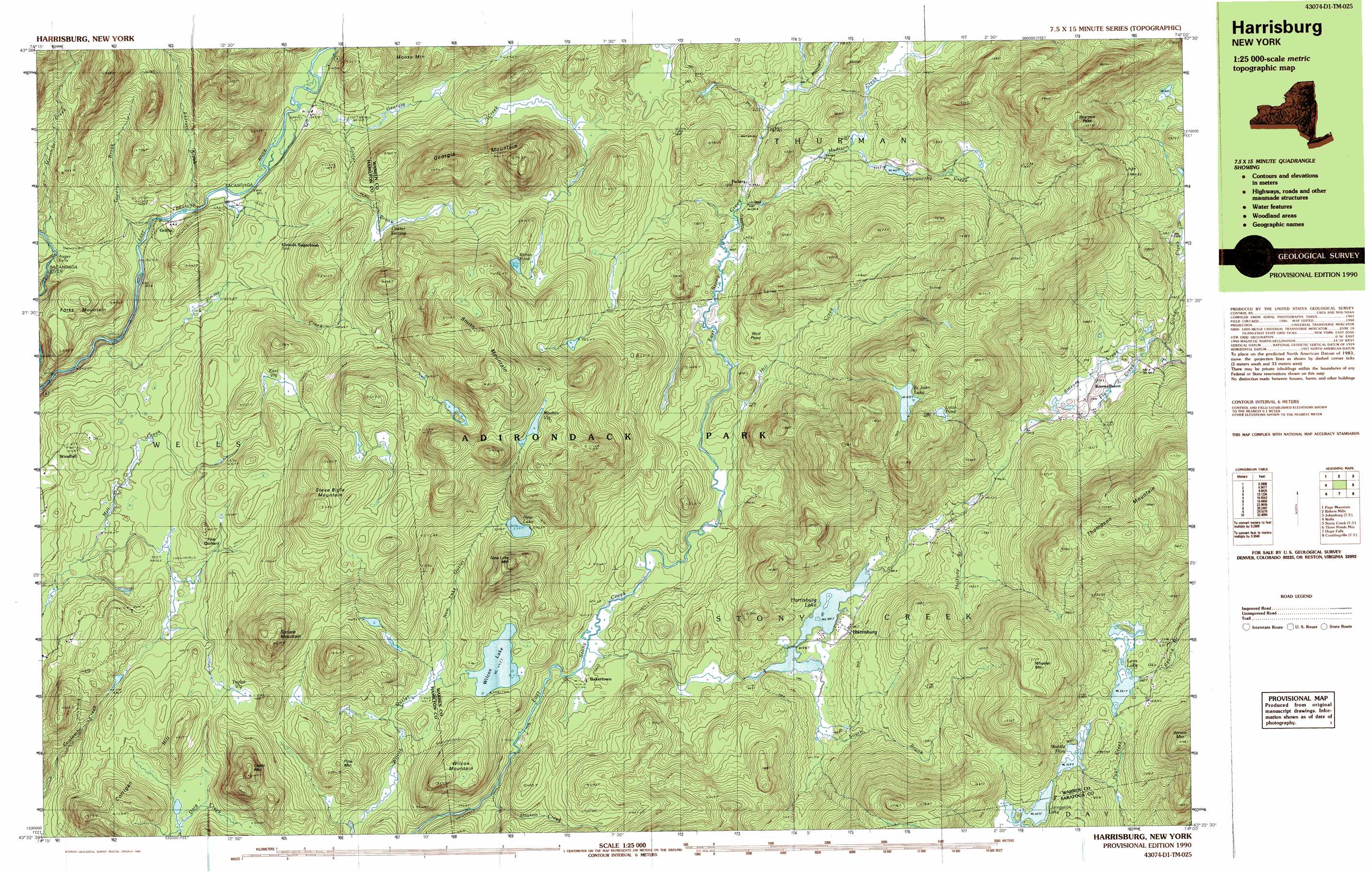
Harrisburg Topo Map New York
To zoom in, hover over the map of Harrisburg
USGS Topo Quad 43074d1 - 1:25,000 scale
| Topo Map Name: | Harrisburg |
| USGS Topo Quad ID: | 43074d1 |
| Print Size: | ca. 39" wide x 24" high |
| Southeast Coordinates: | 43.375° N latitude / 74° W longitude |
| Map Center Coordinates: | 43.4375° N latitude / 74.125° W longitude |
| U.S. State: | NY |
| Filename: | k43074d1.jpg |
| Download Map JPG Image: | Harrisburg topo map 1:25,000 scale |
| Map Type: | Topographic |
| Topo Series: | 7.5´x15´ |
| Map Scale: | 1:25,000 |
| Source of Map Images: | United States Geological Survey (USGS) |
| Alternate Map Versions: |
Harrisburg NY 1990, updated 1990 Download PDF Buy paper map Harrisburg NY 1997, updated 2000 Download PDF Buy paper map |
1:24,000 Topo Quads surrounding Harrisburg
Sabael |
Gore Mountain |
North Creek |
Chestertown |
|
Kunjamuk River |
Bakers Mills |
Johnsburg |
The Glen |
|
Wells |
Harrisburg |
Stony Creek |
Warrensburg |
|
Cathead Mountain |
Ohmer Mountain |
Conklingville |
Lake Luzerne |
|
Jackson Summit |
Northville |
Edinburg |
Porter Corners |
Corinth |
> Back to 43074a1 at 1:100,000 scale
> Back to 43074a1 at 1:250,000 scale
> Back to U.S. Topo Maps home
Harrisburg topo map: Gazetteer
Harrisburg: Capes
Wolf Point elevation 467m 1532′Harrisburg: Falls
Auger Falls elevation 388m 1272′Harrisburg: Lakes
Harrisburg Lake elevation 455m 1492′Little Pond elevation 693m 2273′
Middle Flow elevation 557m 1827′
New Lake elevation 539m 1768′
Saint John Lake elevation 675m 2214′
Shiras Pond elevation 560m 1837′
Wilcox Lake elevation 442m 1450′
Harrisburg: Populated Places
Bakertown elevation 415m 1361′Fullers elevation 439m 1440′
Girards Sugarbush elevation 432m 1417′
Griffin elevation 396m 1299′
Harrisburg elevation 471m 1545′
Knowelhurst elevation 482m 1581′
Harrisburg: Reservoirs
Lens Lake elevation 561m 1840′Harrisburg: Streams
Cotter Brook elevation 390m 1279′Dayton Creek elevation 401m 1315′
Extract Brook elevation 378m 1240′
Fly Creek elevation 461m 1512′
Georgia Creek elevation 411m 1348′
Halfway Brook elevation 454m 1489′
Hill Creek elevation 420m 1377′
Jimmy Creek elevation 341m 1118′
Langworthy Creek elevation 453m 1486′
Macomber Creek elevation 415m 1361′
Madison Creek elevation 433m 1420′
New Lake Outlet elevation 422m 1384′
Smears Creek elevation 472m 1548′
South Brook elevation 408m 1338′
Towers Brook elevation 368m 1207′
Harrisburg: Summits
Bearpen Peak elevation 768m 2519′Cattle Mountain elevation 638m 2093′
Corrigan Hill elevation 521m 1709′
Forks Mountain elevation 468m 1535′
Georgia Mountain elevation 691m 2267′
New Lake Mountain elevation 664m 2178′
Pine Mountain elevation 506m 1660′
Pine Orchard elevation 491m 1610′
Smith Mountain elevation 769m 2522′
Spruce Mountain elevation 675m 2214′
Steve Bigle Mountain elevation 648m 2125′
Thompson Mountain elevation 802m 2631′
Wheeler Mountain elevation 774m 2539′
Wilcox Mountain elevation 518m 1699′
Harrisburg: Swamps
Cotter Swamp elevation 489m 1604′East Vly elevation 489m 1604′
Masher Vly elevation 657m 2155′
Taylor Vly elevation 448m 1469′
Harrisburg digital topo map on disk
Buy this Harrisburg topo map showing relief, roads, GPS coordinates and other geographical features, as a high-resolution digital map file on DVD:
New York, Vermont, Connecticut & Western Massachusetts
Buy digital topo maps: New York, Vermont, Connecticut & Western Massachusetts